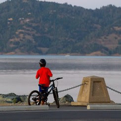
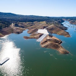
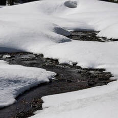
 Oroville Recreation Advisory Committee The Oroville Recreation Advisory Committee (ORAC) met today, Feb. 3 at the Southside Community Center in Oroville. ORAC was established by the Federal Energy Regulatory Commission (FERC) to review and provide recommendations regarding the Department of Water Resources (DWR) recreation plan for the Oroville Facilities. The 13-member committee is made up of representatives from state and local government, recreation groups, and business and community organizations. To obtain a summary of the meeting, send a request to oroville@water.ca.gov. 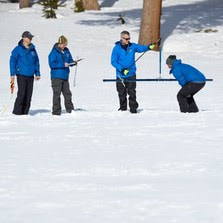 SNOW SURVEY SHOWS SIGNIFICANT BOOST TO SNOWPACK On Wednesday, DWR conducted the second snow survey of the season at Phillips Station. The manual survey recorded 85.5 inches of snow depth and a snow water equivalent of 33.5 inches, which is 193 percent of average for this location on February 1. The snow water equivalent measures the amount of water contained in the snowpack and is a key component of DWR’s water supply forecast. Statewide, the snowpack is 205 percent of average for this date. Two months remain until April 1, when the state snowpack usually peaks. The snowpack received a significant boost from one of the wettest three-week periods on record in California, following the driest three-year period on record. California also experienced above average precipitation in December just months after one of the hottest heatwaves in state history in September. DWR’s electronic readings from 130 snow sensors placed throughout the state indicate the statewide snowpack’s snow water equivalent is 33.7 inches, or 205 percent of average for this date. While those results are currently outpacing the record 1982-83 season, two months still remain. Periodic rain and snow over the next several months will be key to get the biggest water supply benefit from the state’s snowpack without posing additional flood risks. Read more about the snow survey in the press release.  NEW VISITOR CENTER HOURS As of last week, the Lake Oroville Visitor Center has expanded hours and is now open to the public Monday through Friday between 9 a.m. and 5 p.m. The Visitor Center offers numerous educational exhibits, a theater featuring videos about the building of Oroville Dam, walking and hiking trails, and a 47-foot-tall observation tower providing unsurpassed panoramic views. Free guided tours for school and community groups are available by reservation. 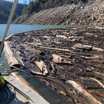 DRIFTWOOD ABATEMENT ONGOING DWR, the Department of Parks and Recreation (DPR), and marina partners at Lake Oroville State Recreation Area advise recreational boaters to navigate carefully on Lake Oroville as driftwood is floating in various areas of the lake. This is a common condition with the rising lake levels and DWR maintenance crews work daily to sequester driftwood from boating areas while DPR maintenance crews remove driftwood at launch ramp areas.  FUEL LOAD MANAGEMENT DWR continues vegetation management and debris cleanup activities around the Feather River Fish Hatchery to remove overgrown ladder fuels and create a more wildfire resilient landscape. In addition, CAL FIRE, Butte County Fire Department, and the California Conservation Corps (CCC) Butte Fire Center continue pile burning activities in the Loafer Creek area and along Oro Dam Boulevard East near the Hyatt Powerplant. Over the next couple weeks, the CCC Chico crew will be cutting and piling material along Canyon Drive to reduce overgrown vegetation near the community of Kelly Ridge. Vegetation management activities will continue through the winter, weather permitting. Smoke from pile burning activities will continue to be visible in the Oroville area. DWR’s Fuel Load Management Plan (FLMP) works to reduce wildfire risk and increase public safety around Lake Oroville. Previous FLMP projects in the Loafer Creek Recreation Area have been identified as contributing to the slowing of the 2020 North Complex Fire as it approached Kelly Ridge, increasing firefighters’ ability to establish a secure fire line, and preventing the fire from progressing. Ongoing management of this critical area remains a high priority for DWR and local partners.  OROVILLE RECREATION Lake Oroville is one of the State Water Project’s premier recreational destinations and one of California’s best fishing spots. The lake provides both warm-water and cold-water fisheries. Below the Oroville Dam, the Thermalito Forebay, Thermalito Afterbay and the Feather River offer additional excellent fishing opportunities for Chinook salmon and steelhead. Paved boat ramps are available at the Spillway, Loafer Point, Loafer Creek, Bidwell Canyon, Lime Saddle, the Thermalito Afterbay, and the Thermalito South Forebay. The Bidwell Canyon Marina is also open from 8 a.m. until sundown and provides a variety of services such as a shuttle and boat rentals. DWR, State Parks, and California Department of Fish & Wildlife maintain over 92 miles of trails in the Oroville area. An interactive map of recreation facilities and their permitted uses (hike, bike, horse, multi) is available on DWR’s Lake Oroville Recreation webpage. CURRENT LAKE OPERATIONS Oroville’s reservoir is about 811 feet elevation and storage is approximately 2.32 million acre-feet (MAF), which is 66 percent of its total capacity and 112 percent of the historical average. Intermittent rain showers are expected over the weekend with sun returning during the week. The Feather River releases are currently at 950 cubic feet per second (cfs). Flows through the City of Oroville are 650 cfs with 300 cfs released from the Thermalito Afterbay Outlet (Outlet) for a total of 950 cfs downstream of the Outlet. DWR continues to assess releases to the Feather River daily. The public can track precipitation, snow, reservoir levels, and more at the California Data Exchange Center. The Lake Oroville gage station is identified as “ORO”. All data as of midnight 2/2/2023.  California is in its third year of drought conditions. With water conservation now a way of life in California, everyone is encouraged to find ways to save water. See tips, tools, and ideas on the Save Our Water website. Information about real time local hydrological conditions, forecasts, and water conditions is available on DWR’s new website California Water Watch.
Oroville Recreation Advisory Committee The Oroville Recreation Advisory Committee (ORAC) will hold a public meeting on Friday, Feb. 3 from 10 a.m. to noon at the Southside Oroville Community Center located at 2959 Lower Wyandotte Road, Oroville, CA, 95966. ORAC was established by the Federal Energy Regulatory Commission (FERC) to review and provide recommendations regarding the Department of Water Resources (DWR) recreation plan for the Oroville Facilities. The 13-member committee is made up of representatives from state and local government, recreation groups, and business and community organizations.  DRIFTWOOD ABATEMENT ONGOING AT LAKE OROVILLE DWR, Department of Parks and Recreation (DPR), and marina partners at Lake Oroville State Recreation Area advise recreational boaters to navigate carefully on Lake Oroville as driftwood is floating in various areas of the lake. This is a common condition with the rising lake levels and DWR has maintenance crews working daily to collect driftwood and haul it to a cove where it will be disposed of when lake levels recede.  NEW VISITOR CENTER HOURS As of this week, the Lake Oroville Visitor Center has expanded hours and is now open to the public Monday through Friday between 9 a.m. and 5 p.m. The Visitor Center offers numerous educational exhibits, a theater featuring videos about the building of Oroville Dam, walking and hiking trails, and a 47-foot-tall observation tower providing unsurpassed panoramic views. Free guided tours for school and community groups are available by reservation.  STATE WATER PROJECT ALLOCATIONS INCREASED DWR announced yesterday that recent storms will allow the State Water Project (SWP) to boost deliveries to 29 public water agencies serving 27 million Californians. Based on the amount of water captured and stored in recent weeks, DWR now expects to deliver 30 percent of requested water supplies – or 1.27 million acre-feet -- in 2023, up from the initial 5 percent announced on Dec. 1. The allocation increase is the direct result of significant precipitation in late December and nine atmospheric rivers in early January that helped fill reservoirs and dramatically increase the Sierra Nevada snowpack. The SWP’s two largest reservoirs (Oroville and San Luis) have gained a combined 1.62 million acre-feet of water in storage -- roughly enough to provide water to 5.6 million households for a year. While Water Year 2023 began with below average precipitation, conditions shifted to above average for the water year-to-date. The updated SWP delivery forecast takes into account current reservoir storage and is based on a conservative runoff forecast. It does not take into account the current Sierra Nevada snowpack. DWR will conduct snow surveys on February 1, March 1, April 1, and May 1 and may further update the allocation as the water supply outlook becomes clearer with the new data. More information about the revised SWP allocations may be found in the press release.  MIDWINTER BALD EAGLE SURVEY Environmental scientists from DWR recently participated in the National Midwinter Bald Eagle Survey on Jan. 6 and Jan. 9. This nationwide effort, coordinated by the USACE, aims to determine bald eagle distribution and identify areas of important winter habitats. This year’s official count was 176 bald eagles for the Lake Oroville Winter Roost and three at the Thermalito Complex. This is the highest count for the Lake Oroville Winter Roost since DWR began survey participation in 2003. Lake Oroville and the Sacramento Valley area provide an ideal habitat for bald eagles. Fish and waterfowl are the eagle’s main food source during this time of the year and large water bodies like Lake Oroville provide a wide variety of fish, and the nearby wetlands and flooded rice fields provide an abundant supply of waterfowl for eagle foraging. The many trees and snags (tall dead trees) near water areas provide prime roosting locations for the bald eagles that migrate to and through the area during the winter months. OROVILLE RECREATION DWR, State Parks, and California Department of Fish & Wildlife maintain over 92 miles of trails in the Oroville area. An interactive map of recreation facilities and their permitted uses (hike, bike, horse, multi) is available on DWR’s Lake Oroville Recreation webpage. With rising lake levels, paved boat ramps are available at the Spillway, Loafer Point, Bidwell Canyon, Lime Saddle, the Thermalito Afterbay, and the Thermalito South Forebay. The Bidwell Canyon Marina is also open from 8 a.m. until sundown and provides a variety of services such as a shuttle and boat rentals. CURRENT LAKE OPERATIONS Oroville’s reservoir is about 804 feet elevation and storage is approximately 2.23 million acre-feet (MAF), which is 63 percent of its total capacity and 110 percent of the historical average. Dry weather continues next week with rain showers possible the first weekend of February. The Feather River releases are currently at 950 cubic feet per second (cfs). Flows through the City of Oroville are 650 cfs with 300 cfs released from the Thermalito Afterbay Outlet (Outlet) for a total of 950 cfs downstream of the Outlet. DWR continues to assess releases to the Feather River daily. The public can track precipitation, snow, reservoir levels, and more at the California Data Exchange Center. The Lake Oroville gage station is identified as “ORO”. All data as of midnight 01/26/2023. California is in its third year of drought conditions. With water conservation now a way of life in California, everyone is encouraged to find ways to save water. See tips, tools, and ideas on the Save Our Water website. Information about real time local hydrological conditions, forecasts, and water conditions is available on DWR’s new website California Water Watch.
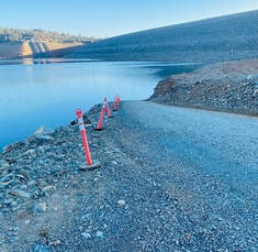
 Midwinter Bald Eagle Survey Environmental scientists from DWR recently participated in the National Midwinter Bald Eagle Survey on Jan. 6 and Jan. 9. This nationwide effort, coordinated by the USACE, aims to determine bald eagle distribution and identify areas of important winter habitats. This year’s official count was 176 bald eagles for the Lake Oroville Winter Roost and three at the Thermalito Complex. This is the highest count for the Lake Oroville Winter Roost since DWR began survey participation in 2003. Lake Oroville and the Feather River area provide an ideal habitat for bald eagles. Fish are one of the eagle’s main food sources and large water bodies like Lake Oroville provide a wide variety of fish and other favorite food sources such as waterfowl, small birds, and mammals. The many trees and snags (tall dead trees) near water areas provide prime roosting and hunting locations for the bald eagles that migrate to and through the area during the winter months. 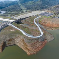 LAKESIDE ACCESS ROAD CLOSED Rising reservoir levels at Lake Oroville have required the closure of the newly constructed Lakeside Access Road, which will not reopen until water levels drop back down later this year. With the road closure in effect, vehicle access to the Spillway Boat Ramp and Day Use Area will now be via Oroville Dam Crest Road. Vehicle access to the Spillway Boat Ramp and Day Use Area is available between 6 a.m. and 8 p.m. There are three other boat ramps at Lake Oroville that are open 24 hours a day: Bidwell Canyon, Loafer Point, and Lime Saddle. At just 60 percent of its total capacity, Lake Oroville still has ample storage to capture storm runoff while providing flood control protection for the Feather River and downstream communities. Water inflows to the reservoir during recent storms have been as high as 50,000 cubic feet per second (cfs) while outflows in the Feather River through Oroville remain at a minimum of 650 cfs. Current outflows are being used to support local water needs and maintain flood control and are not part of water deliveries to Southern California. In addition, DWR Oroville Field Division Civil Maintenance crews are patrolling Lake Oroville daily to collect woody debris as part of normal operations during this time of year. Boaters are advised to be alert for floating debris, which is expected during high reservoir inflows. 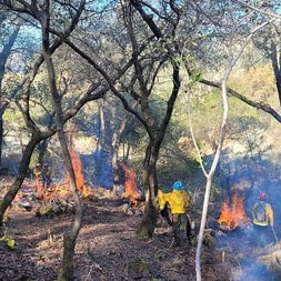 FUEL LOAD MANAGEMENT DWR continues vegetation management activities around the Oroville area to remove overgrown vegetation and create a more wildfire resilient landscape. Over the next few months, you may see crews working in various areas including Loafer Creek, Canyon Drive, along Oro Dam Blvd. East, and the Feather River Fish Hatchery. CAL FIRE, Butte County Fire Department, Butte County Sheriff’s Office, California Conservation Corps (CCC), and crews from the Butte Fire Center continue to cut, pile, chip, and pile burn as weather allows. Vegetation management activities will continue through the winter, weather permitting. Smoke from pile burning activities will continue to be visible in the Oroville area. DWR’s Fuel Load Management Plan (FLMP) works to reduce wildfire risk and increase public safety around Lake Oroville. Previous FLMP projects in the Loafer Creek Recreation Area have been identified as contributing to the slowing of the 2020 North Complex Fire as it approached Kelly Ridge, increasing firefighters’ ability to establish a secure fire line and preventing the fire from progressing. Ongoing management of the FLMP remains a high priority for DWR and local partners. 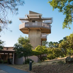 OROVILLE RECREATION The Lake Oroville Visitor Center is open Tuesday through Thursday, 9 a.m. to 5 p.m. and offers visitors numerous educational exhibits, a theater featuring videos about the building of Oroville Dam, walking and hiking trails, and a 47-foot-tall observation tower providing unsurpassed panoramic views. DWR, State Parks, and State Fish & Wildlife maintain over 92 miles of trails in the Oroville area, including those around the Lake Oroville Visitor Center. There are paved, accessible trails with only slight elevation changes by the Visitor Center and the North Forebay Day Use Area. Other trails, such as the Brad Freeman Trail between the Spillway Day Use Area and the Diversion Pool, offer steep elevation changes to challenge hikers and mountain bikers. The Saddle Dam Trailhead has facilities for equestrians, including a large parking area to accommodate horse trailers, water trough, and hitching posts, and easy access to trails designated for hikers and horses. An interactive map of recreation facilities and their permitted uses (hike, bike, horse, multi) is available on DWR’s Lake Oroville Recreation webpage. With rising lake levels, paved boat ramps are available at the Spillway, Loafer Point, Bidwell Canyon, the Thermalito Afterbay, and the Thermalito South Forebay. The Bidwell Canyon Marina is also open from 8 a.m. until sundown and provides a variety of services such as a shuttle and boat rentals. CURRENT LAKE OPERATIONS Oroville’s reservoir is about 793 feet elevation and storage is approximately 2.12 million acre-feet (MAF), which is 60 percent of its total capacity and 107 percent of the historical average. Dry weather and sunshine are returning to the forecast for the upcoming week. The Feather River releases are currently at 950 cubic feet per second (cfs). Flows through the City of Oroville are 650 cfs with 300 cfs released from the Thermalito Afterbay Outlet (Outlet) for a total of 950 cfs downstream of the Outlet. DWR continues to assess releases to the Feather River daily. The public can track precipitation, snow, reservoir levels, and more at the California Data Exchange Center. The Lake Oroville gage station is identified as “ORO”. All data as of midnight 01/19/2023.  California is in its third year of drought conditions. With water conservation now a way of life in California, everyone is encouraged to find ways to save water. See tips, tools, and ideas on the Save Our Water website. Information about real time local hydrological conditions, forecasts, and water conditions is available on DWR’s new website California Water Watch.
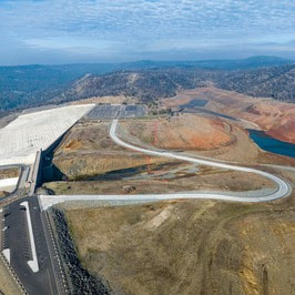 Lakeside Access Road Closed Rising reservoir levels at Lake Oroville have required the closure of the newly constructed Lakeside Access Road, which will not reopen until water levels drop back down later this year. With the road closure in effect, vehicle access to the Spillway Boat Ramp and Day Use Area will now be via Oroville Dam Crest Road. Vehicle access to the Spillway Boat Ramp and Day Use Area is available between 6 a.m. and 8 p.m. There are three other boat ramps at Lake Oroville that are open 24 hours a day: Bidwell Canyon, Loafer Point, and Lime Saddle. Since Dec. 1, 2022, Lake Oroville has seen over a 100-foot rise in elevation with storage levels at 1.79 million acre-feet thanks to a series of atmospheric rivers that delivered significant rain and snow to the Feather River watershed. However, due to historic drought throughout California, most major reservoirs, including Lake Oroville, remain low. At just 51 percent of its total capacity, Lake Oroville still has ample storage to capture storm runoff while providing flood control protection for the Feather River and downstream communities. Water inflows to the reservoir during recent storms have been as high as 50,000 cubic feet per second (cfs) while outflows in the Feather River through Oroville remain at a minimum of 650 cfs. Current outflows are being used to support local water needs and maintain flood control and are not part of water deliveries to Southern California. As lake levels continue to rise with inflows, outflows from Oroville Dam may increase under flood control guidelines from the U.S. Army Corps of Engineers (USACE). The Department of Water Resources (DWR) is required to maintain storage for continued rainfall and snowmelt as the wet season progresses. This coordinated release of water helps prevent catastrophic flooding in downstream communities. In addition, DWR Oroville Field Division Civil Maintenance crews are patrolling Lake Oroville daily to collect woody debris as part of normal operations during this time of year. Boaters are advised to be alert for floating debris, which is expected during high reservoir inflows. 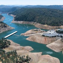 LIME SADDLE BOAT RAMP NOW OPEN The Lime Saddle paved ramp reopened for boat launching last week. Located along the west branch of the north fork arm of Lake Oroville and accessible from Pentz Road, Lime Saddle offers picnic tables, sun shelters, flush toilets (all ADA accessible), a drinking fountain, a telephone, a fish cleaning station, and trash receptacles. The marina, which is open from 8 a.m. to sundown, also offers gas for boats, a general store with bait and tackle, and a pump-out station. The Bidwell Canyon Marina is also open from 8 a.m. until sundown and provides a variety of services such as a shuttle and boat rentals.  SNOW SURVEY DWR conducted its first Phillips Station snow survey on Jan. 3. The manual survey recorded 55.5 inches of snow depth and a snow water equivalent of 17.5 inches, which is 177 percent of average for this location. The snow water equivalent measures the amount of water contained in the snowpack and is a key component of DWR’s water supply forecast. Statewide the snowpack is 174 percent of average for this date. On average, the Sierra snowpack supplies about 30 percent of California’s water needs and is an important factor in determining how DWR manages the state’s water resources. Its natural ability to store water is why the Sierra snowpack is often referred to as California's “frozen reservoir.” A below-average snowpack impacts water users across the state, putting further stress on the environment and critical groundwater supplies. More information about the first snow survey can be found in DWR’s press release. 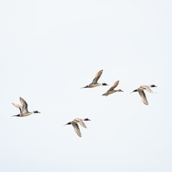 OROVILLE RECREATION With approximately 11,800-acres of forested upland and riparian habitat along the Feather River and around the Thermalito Afterbay, the Oroville Wildlife Area is open for hunting, with most hunters pursuing waterfowl at the Afterbay. Interior ponds have also filled with enough water to permit duck hunting. Oroville Wildlife Area is a “Type C” wildlife area (hunting pass not required) and is open for hunting seven days a week with entry hours limited from 1.5 hours before sunrise to one hour after sunset. California Department of Fish and Wildlife hunting regulations are available online. The Lake Oroville Visitor Center is open to the public Tuesday through Thursday from 9 a.m. to 5 p.m. Pick up the Lake Oroville Trails Map – which shows more than 92 miles of trails available to equestrians, bicyclists, and hikers – at Lake Oroville State Recreation Area kiosks, the Oroville Area Chamber of Commerce, or the Feather River Recreation and Parks District. An interactive map of recreation facilities and their permitted uses (hike, bike, horse, multi) is available on DWR’s interactive Lake Oroville Recreation webpage. CURRENT LAKE OPERATIONS Oroville’s reservoir is about 762 feet elevation and storage is approximately 1.79 million acre-feet (MAF), which is 51 percent of its total capacity and 93 percent of the historical average. Rain will continue over the weekend and into early next week, with a break in wet weather expected midweek. The Feather River releases are currently at 950 cubic feet per second (cfs). Flows through the City of Oroville are 650 cfs with 300 cfs released from the Thermalito Afterbay Outlet (Outlet) for a total of 950 cfs downstream of the Outlet. DWR continues to assess releases to the Feather River daily. The public can track precipitation, snow, reservoir levels, and more at the California Data Exchange Center. The Lake Oroville gage station is identified as “ORO”. All data as of midnight 01/12/2023.  California is in its third year of drought conditions. With water conservation now a way of life in California, everyone is encouraged to find ways to save water. See tips, tools, and ideas on the Save Our Water website. Information about real time local hydrological conditions, forecasts, and water conditions is available on DWR’s new website California Water Watch.
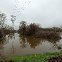 DWR Prepares for Storms and Potential Flooding The California Department of Water Resources (DWR) is preparing for a series of storms in the next ten days that could potentially bring additional flooding to communities already inundated by recent downpours. The storm battering the state Wednesday was the third in a series of atmospheric river storms that have impacted Northern California in the space of a week. DWR activated the State-Federal Flood Operations Center (FOC) on Jan. 3 and has been closely monitoring and communicating forecasts and making high-water notification calls to keep locals and partner agencies informed of elevated river levels. The FOC is working closely with the National Weather Service, the United States Army Corps of Engineers, the United States Bureau of Reclamation, CalOES, and California counties, and is participating in coordination calls to take proactive steps to respond and prepare for impacts from flooding statewide. It is still important to note that these storms have not ended the drought. While Lake Oroville has seen a 65-foot rise in elevation since Dec. 1, major reservoir storage remains below average, and conditions could turn dry again this winter, offsetting recent rain and snow. Information on current Butte County road closures due to flooding and sandbag resources can be found on Butte County’s website. More information on DWR storm preparation can be found in its recent press release.  LIME SADDLE BOAT RAMP NOW OPEN The Lime Saddle paved ramp reopened for boat launching this week. Located along the west branch of the north fork arm of Lake Oroville and accessible from Pentz Road, Lime Saddle offers picnic tables, sun shelters, flush toilets (all ADA accessible), a drinking fountain, a telephone, a fish cleaning station, and trash receptacles. The marina also offers gas for boats, a boat repair and supply shop, a general store with bait and tackle, and a pump-out station. Paved boat ramps remain available at the Spillway, Loafer Point, Bidwell Canyon, the Thermalito Afterbay, and the Thermalito South Forebay. Both the Lime Saddle and Bidwell Canyon marinas are open from 8 a.m. until sundown with shuttle service and boat rentals available. 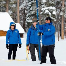 SNOW SURVEY DWR conducted its first Phillips Station snow survey on Jan. 3. The manual survey recorded 55.5 inches of snow depth and a snow water equivalent of 17.5 inches, which is 177 percent of average for this location. The snow water equivalent measures the amount of water contained in the snowpack and is a key component of DWR’s water supply forecast. Statewide the snowpack is 174 percent of average for this date. “Big snow totals are always welcome, but we still have a long way to go before the critical April 1 total,” said Sean de Guzman, DWR’s snow surveys and water supply forecasting unit manager. “It’s always great to be above average this early in the season, but we must be resilient and remember what happened last year. If January through March of 2023 turn out to be similar to last year, we would still end the water year in severe drought with only half of an average year's snowpack.” On average, the Sierra snowpack supplies about 30 percent of California’s water needs and is an important factor in determining how DWR manages the state’s water resources. Its natural ability to store water is why the Sierra snowpack is often referred to as California's “frozen reservoir.” A below-average snowpack impacts water users across the state, putting further stress on the environment and critical groundwater supplies. More information about the first snow survey can be found in DWR’s press release.  FUEL LOAD MANAGEMENT DWR continues vegetation management activities around the Oroville area to remove overgrown vegetation and create a more wildfire resilient landscape. Over the next few months you may see crews working in various areas including Loafer Creek, Canyon Drive, along Oro Dam Blvd. East, and the Feather River Fish Hatchery. CAL FIRE, Butte County Fire Department, Butte County Sheriff’s Office, California Conservation Corps (CCC), and crews from the Butte Fire Center continue to cut, pile, chip, and pile burn as weather allows. Vegetation management activities will continue through the winter, weather permitting. Smoke from pile burning activities will continue to be visible in the Oroville area. DWR’s Fuel Load Management Plan (FLMP) works to reduce wildfire risk and increase public safety around Lake Oroville. Previous FLMP projects in the Loafer Creek Recreation Area have been identified as contributing to the slowing of the 2020 North Complex Fire as it approached Kelly Ridge, increasing firefighters’ ability to establish a secure fire line, and preventing the fire from progressing. Ongoing management of the FLMP remains a high priority for DWR and local partners. 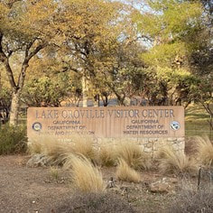 OROVILLE RECREATION The Lake Oroville Visitor Center is open to the public Tuesday through Thursday from 9 a.m. to 5 p.m. Pick up the Lake Oroville Trails Map – which shows more than 92 miles of trails available to equestrians, bicyclists, and hikers – at Lake Oroville State Recreation Area kiosks, the Oroville Area Chamber of Commerce, or the Feather River Recreation and Parks District. An interactive map of recreation facilities and their permitted uses (hike, bike, horse, multi) is available on DWR’s interactive Lake Oroville Recreation webpage. CURRENT LAKE OPERATIONS Oroville’s reservoir is about 724 feet elevation and storage is approximately 1.44 million acre-feet (MAF), which is 41 percent of its total capacity and 77 percent of the historical average. Wet weather and strong wind gusts remain in the forecast for the upcoming week due to continued atmospheric rivers that are hitting the West Coast. The Feather River releases are currently at 950 cubic feet per second (cfs). Flows through the City of Oroville are 650 cfs with 300 cfs released from the Thermalito Afterbay Outlet (Outlet) for a total of 950 cfs downstream of the Outlet. DWR continues to assess releases to the Feather River daily. The public can track precipitation, snow, reservoir levels, and more at the California Data Exchange Center. The Lake Oroville gage station is identified as “ORO”. All data as of midnight 12/29/2022. California is in its third year of drought conditions. With water conservation now a way of life in California, everyone is encouraged to find ways to save water. See tips, tools, and ideas on the Save Our Water website. Information about real time local hydrological conditions, forecasts, and water conditions is available on DWR’s new website California Water Watch.
 Loafer Point Boat Ramp Open The Loafer Point paved ramp reopened for boat launching this week. The ramp has three launch lanes at current lake levels, a boarding float, and is adjacent to the Loafer Creek Recreation Day Use Area and Campground with nearby trails, campgrounds, boating, and marina store. Paved boat ramps are also available at Bidwell Canyon, the Thermalito Afterbay, and the Thermalito South Forebay. Both the Lime Saddle and Bidwell Canyon marinas are open from 8 a.m. until sundown with shuttle service and boat rentals available.  ATMOSPHERIC RIVERS This past week and heading into the New Year, a series of atmospheric rivers are hitting California, further bolstering the Northern Sierra snowpack, which is at 128 percent of normal as of Dec. 29. Atmospheric rivers are air currents that carry huge amounts of water vapor from the tropics to the West Coast and are a key feature in the California water cycle. Atmospheric rivers account for 40 to 60 percent of California’s annual precipitation, often in powerful downpours that can hit in rapid succession. On the flip side, successive years without significant atmospheric river events has led to severe drought conditions throughout most of the state. California still needs above average precipitation throughout the winter to offset record-setting drought conditions. The California Department of Water Resources (DWR) is conducting the first snow survey of the season on Jan. 3, pending good weather conditions. Track precipitation, reservoir levels and snowpack data at the California Data Exchange Center. 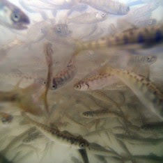 FISH HATCHERY INCREASING FALL-RUN CHINOOK SALMON PRODUCTION DWR and the California Department of Fish and Wildlife (CDFW) will increase the Feather River Fish Hatchery’s production of fall-run Chinook salmon in 2023 to approximately 9.5 million fish to combat the impacts of drought and a thiamine deficiency affecting natural spawning and in-river production. The hatchery, owned by DWR and operated by CDFW, is seeking to produce approximately 8 million fall-run Chinook salmon smolts and 1.5 million fall-run Chinook salmon fingerlings in 2023 – a 3.5 million increase over typical production goals. Two million of the additional salmon smolts produced will be trucked to release sites in the San Pablo and San Francisco bays to maximize survival. Another 1.5 million of these additional fish will be released into the Feather River earlier in the season and at a smaller size than typical river releases. This is an experimental effort to take advantage of more favorable weather and river conditions in early spring. For more information about increased fall-run Chinook Salmon production, read CDFW’s press release.  STEELHEAD SPAWNING Feather River Fish Hatchery staff began steelhead spawning operations this week and will continue through early February. These fish will enter the hatchery via the fish ladder that leads up from the Feather River Fish Barrier Dam and can be seen at the viewing windows and facility. Once the spawned fish eggs have hatched, the juvenile fish will be reared at the hatchery for a full year and then released next winter into the Feather River. If there are any surplus fish beyond the production goal of 400,000, fish may be planted into the Thermalito Afterbay for recreational fishing. Like the salmon that populate the Feather River, steelhead trout migrate from freshwater to marine (ocean), returning to freshwater environments to spawn. Unlike salmon, they can spawn several times during their lifetime and can live up to eight years. The “steelhead” name comes from their appearance, a more streamlined shape than Chinook salmon with a silvery or brassy color as an adult. The Feather River Fish Hatchery is a California State Water Project (SWP) facility built in the late 1960s to mitigate impacts on fish migration resulting from the construction of Oroville Dam which prevented access to spawning grounds further upstream. Daily visiting hours at the facility are 8 a.m. to 3 p.m. 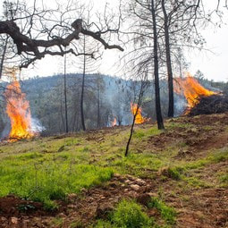 FUEL LOAD MANAGEMENT DWR continues vegetation management activities around the Oroville area to remove overgrown vegetation and create a more wildfire resilient landscape. Over the next few months you may see crews working in various areas including Loafer Creek, Canyon Drive, along Oro Dam Blvd. East, and the Feather River Fish Hatchery. CAL FIRE, Butte County Fire Department, Butte County Sheriff’s Office, California Conservation Corps (CCC), and crews from the Butte Fire Center continue to cut, pile, chip, and pile burn as weather allows. Vegetation management activities will continue through the winter, weather permitting. Smoke from pile burning activities will continue to be visible in the Oroville area. DWR’s Fuel Load Management Plan (FLMP) works to reduce wildfire risk and increase public safety around Lake Oroville. Previous FLMP projects in the Loafer Creek Recreation Area have been identified as contributing to the slowing of the 2020 North Complex Fire as it approached Kelly Ridge, increasing firefighters’ ability to establish a secure fire line, and preventing the fire from progressing. Ongoing management of the FLMP remains a high priority for DWR and local partners. 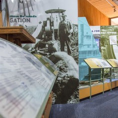 OROVILLE RECREATION The Lake Oroville Visitor Center is open to the public Tuesday through Thursday from 9 a.m. to 5 p.m. Pick up the Lake Oroville Trails Map, which shows more than 92 miles of trails available to equestrians, bicyclists, and hikers, at Lake Oroville State Recreation Area kiosks, the Oroville Area Chamber of Commerce, or the Feather River Recreation and Parks District. An interactive map of recreation facilities and their permitted uses (hike, bike, horse, multi) is available on DWR’s interactive Lake Oroville Recreation webpage. CURRENT LAKE OPERATIONS Oroville’s reservoir is about 684 feet elevation and storage is approximately 1.14 million acre-feet (MAF), which is 32 percent of its total capacity and 62 percent of the historical average. A series of storms will deliver rain to the valley and snow to the Sierra through the New Year weekend and into next week, further bolstering lake levels. The Feather River releases are currently at 950 cubic feet per second (cfs). Flows through the City of Oroville are 650 cfs with 300 cfs released from the Thermalito Afterbay Outlet (Outlet) for a total of 950 cfs downstream of the Outlet. DWR continues to assess releases to the Feather River daily. The public can track precipitation, snow, reservoir levels, and more at the California Data Exchange Center. The Lake Oroville gage station is identified as “ORO”. All data as of midnight 12/29/2022.  California is in its third year of drought conditions. With water conservation now a way of life in California, everyone is encouraged to find ways to save water. See tips, tools, and ideas on the Save Our Water website. Information about real time local hydrological conditions, forecasts, and water conditions is available on DWR’s new website California Water Watch.
 Fish Hatchery Increasing Fall-Run Chinook Salmon Production The California Department of Water Resources (DWR) and the California Department of Fish and Wildlife (CDFW) will increase the Feather River Fish Hatchery’s production of fall-run Chinook salmon in 2023 to approximately 9.5 million fish to combat the impacts of drought and a thiamine deficiency affecting natural spawning and in-river production. The hatchery, owned by DWR and operated by CDFW, is seeking to produce approximately 8 million fall-run Chinook salmon smolts and 1.5 million fall-run Chinook salmon fingerlings in 2023 – a 3.5 million increase over typical production goals. Two million of the additional salmon smolts produced will be trucked to release sites in the San Pablo and San Francisco bays to maximize survival. Another 1.5 million of these additional fish will be released into the Feather River earlier in the season and at a smaller size than typical river releases. This is an experimental effort to take advantage of more favorable weather and river conditions in early spring. For more information about increased fall-run Chinook Salmon production, read CDFW’s press release. 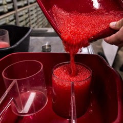 STEELHEAD SPAWNING Feather River Fish Hatchery staff will begin steelhead spawning operations Dec. 28 and continue through early February. These fish will enter the hatchery via the fish ladder that leads up from the Feather River Fish Barrier Dam and can be seen at the viewing windows and facility. Once the spawned fish eggs have hatched, the juvenile fish will be reared at the hatchery for a full year and then released next winter into the Feather River. If there are any surplus fish beyond the production goal of 400,000, fish may be planted into the Thermalito Afterbay for recreational fishing. Like the salmon that populate the Feather River, steelhead trout migrate from freshwater to marine (ocean), returning to freshwater environments to spawn. Unlike salmon, they can spawn several times during their lifetime and can live up to eight years. The “steelhead” name comes from their appearance, a more streamlined shape than Chinook salmon with a silvery or brassy color as an adult. The Feather River Fish Hatchery is a California State Water Project (SWP) facility built in the late 1960s to mitigate impacts on fish migration resulting from the construction of Oroville Dam which prevented access to spawning grounds further upstream. Daily visiting hours at the facility are 8 a.m. to 3 p.m. 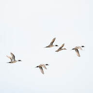 HUNTING AT OROVILLE WILDLIFE AREA With approximately 11,800-acres of forested upland and riparian habitat along the Feather River and around the Thermalito Afterbay, the Oroville Wildlife Area is open for hunting with most hunters pursuing waterfowl at the Afterbay. Some interior ponds have also filled with enough water to permit duck hunting, while upland hunters have had success harvesting quail, squirrels, and rabbits this time of year. In the spring, CDFW will draw permits for special turkey hunt opportunities including the Junior Hunt weekend and select weekends. Turkey hunting is not permitted in the fall at the Oroville Wildlife Area. Check CDFW hunting regulations for more information. Oroville Wildlife Area is a “Type C” wildlife area (hunting pass not required) and is open for hunting seven days a week with entry hours limited from 1.5 hours before sunrise to one hour after sunset. No rifles or pistols may be used or possessed on the wildlife area except at the designated shooting range (Rabe Rd. Shooting Range off Larkin Rd.; open seven days a week from sunrise to sunset). Lead ammunition cannot be used while hunting in California. 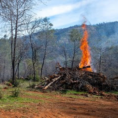 FUEL LOAD MANAGEMENT DWR continues vegetation management activities around the Oroville area to remove overgrown vegetation and create a more wildfire resilient landscape. Over the next few months you may see crews working in various areas including Loafer Creek, Canyon Drive, along Oro Dam Blvd. East, and the Feather River Fish Hatchery. CAL FIRE, Butte County Fire Department, Butte County Sheriff’s Office, California Conservation Corps (CCC), and crews from the Butte Fire Center continue to cut, pile, chip, and pile burn as weather allows. Vegetation management activities will continue through the winter, weather permitting. Smoke from pile burning activities will continue to be visible in the Oroville area. DWR’s Fuel Load Management Plan (FLMP) works to reduce wildfire risk and increase public safety around Lake Oroville. Previous FLMP projects in the Loafer Creek Recreation Area have been identified as contributing to the slowing of the 2020 North Complex Fire as it approached Kelly Ridge, increasing firefighters’ ability to establish a secure fire line, and preventing the fire from progressing. Ongoing management of the FLMP remains a high priority for DWR and local partners.  OROVILLE RECREATION DWR and California Department of Parks and Recreation (State Parks) maintain over 92 miles of trails in the Oroville area. Popular with mountain bikers, hikers and equestrians, trails near the Thermalito Diversion Pool can be accessed from Cherokee Road and offer ample opportunity for viewing the local wildlife. Trails along the south side of the Diversion Pool can be accessed from the trail access parking lot west of the South Feather Powerhouse and accessible from Hyatt Powerplant Road. Trails and their permitted uses (hike, bike, horse, multi), day use areas, boat ramps, and other recreation facilities are featured on DWR’s interactive Lake Oroville Recreation webpage. The Lake Oroville Visitor Center is open Tuesday through Thursday from 9 a.m. to 5 p.m. and offers visitors numerous educational exhibits, a theater featuring videos about the building of Oroville Dam, and walking and hiking trails. The Bidwell Canyon concrete boat ramp is open at Lake Oroville. State Parks has provided a floating dock for users at the ramp along with portable restroom facilities. Both the Lime Saddle and Bidwell Canyon marinas are open from 8 a.m. until sundown with shuttle service and boat rentals available. Paved boat ramps are also available at the Thermalito Afterbay and the Thermalito South Forebay. CURRENT LAKE OPERATIONS Oroville’s reservoir is about 671 feet elevation and storage is approximately 1.04 million acre-feet (MAF), which is 30 percent of its total capacity and 57 percent of the historical average. Fog in the valley is expected through the holiday weekend with intermittent rain showers throughout the week. The Feather River releases are currently at 950 cubic feet per second (cfs). Flows through the City of Oroville are 650 cfs with 300 cfs released from the Thermalito Afterbay Outlet (Outlet) for a total of 950 cfs downstream of the Outlet. DWR continues to assess releases to the Feather River daily. The public can track precipitation, snow, reservoir levels, and more at the California Data Exchange Center. The Lake Oroville gage station is identified as “ORO”. All data as of midnight 12/22/2022. California is in its third year of drought conditions. With water conservation now a way of life in California, everyone is encouraged to find ways to save water. See tips, tools, and ideas on the Save Our Water website. Information about real time local hydrological conditions, forecasts, and water conditions is available on DWR’s new website California Water Watch.
 Paved Boat Ramp Reopens Thanks to recent rain showers in the valley and feet of snowfall in the Sierra mountains, water levels at Lake Oroville have risen enough to reopen the Bidwell Canyon concrete boat ramp. With Bidwell Canyon reopened, the gravel spillway ramp is now closed. The California Department of Parks and Recreation (State Parks) has provided a floating dock for users at the ramp along with portable restroom facilities. Both the Lime Saddle and Bidwell Canyon marinas are open from 8 a.m. until sundown with shuttle service and boat rentals available. Paved boat ramps are also available at the Thermalito Afterbay and the Thermalito South Forebay.  HUNTING AT OROVILLE WILDLIFE AREA With approximately 11,800-acres of forested upland and riparian habitat along the Feather River and around the Thermalito Afterbay, the Oroville Wildlife Area is open for hunting with most hunters pursuing waterfowl at the Afterbay. Some interior ponds have also filled with enough water to permit duck hunting, while upland hunters have had success harvesting quail, squirrels, and rabbits this time of year. In the spring, California Department of Fish and Wildlife (CDFW) will draw permits for special turkey hunt opportunities including the Junior Hunt weekend, and the first, third, and fifth weekends and Wednesdays of the spring season. Turkey hunting is not permitted in the fall at the Oroville Wildlife Area. Oroville Wildlife Area is a “Type C” wildlife area (hunting pass not required) and is open for hunting seven days a week with entry hours limited from 1.5 hours before sunrise to one hour after sunset. No rifles or pistols may be used or possessed on the wildlife area except at the designated shooting range (Rabe Rd. Shooting Range off Larkin Rd.; open seven days a week from sunrise to sunset). Lead ammunition cannot be used while hunting in California.  WINTER OUTLOOK Even with the Northern Sierra snowpack measuring 180 percent of normal as of Dec. 15, the Department of Water Resources (DWR) is reminding the public of ongoing drought conditions throughout California. As the state enters its fourth year of drought, California Water Watch shows most of the state is still in moderate, severe, or extreme drought conditions, and the state’s groundwater basins and environments are still stressed from years of severely dry conditions. While early season precipitation totals may be cause for cautious optimism, last year’s above average December was followed by historic dry conditions January through March. This early in the winter, California must proceed with caution and continue to embrace solutions proposed in the Newsom Administration’s Water Supply Strategy for Adapting to a Hotter, Drier Future. The National Oceanic and Atmospheric Administration (NOAA) is predicting a La Niña winter with dry conditions in Southern California and equal chances of wet or dry conditions in central and northern parts of the state. Early snow totals are only helpful if they translate into runoff into the state's streams, rivers, and reservoirs, particularly in the spring and summer months. DWR is investing in several new tools to both predict and capture runoff, such as investing in additional Airborne Snow Observatory flights and improving runoff forecasting abilities with more sophisticated data collection. While the winter season has started positively, the most important measurement of the year will be April 1, when the snowpack is typically at its highest. You can track precipitation and snowpack data on the California Data Exchange Center website.  VEGETATION MANAGEMENT CONTINUES IN OROVILLE AREA DWR continues vegetation management and debris cleanup activities around the Feather River Fish Hatchery to remove overgrown ladder fuels and create a more wildfire resilient landscape. In addition, CAL FIRE, Butte County Fire Department, and the California Conservation Corps (CCC) Butte Fire Center continue pile burning activities in the Loafer Creek area and along Oro Dam Boulevard East near the Hyatt Powerplant. Over the next couple weeks, the CCC Chico crew will be cutting and piling material along Canyon Drive to reduce overgrown vegetation near the community of Kelly Ridge. Vegetation management activities will continue through the winter, weather permitting. Smoke from pile burning activities will continue to be visible in the Oroville area. DWR’s Fuel Load Management Plan (FLMP) works to reduce wildfire risk and increase public safety around Lake Oroville. Previous FLMP projects in the Loafer Creek Recreation Area have been identified as contributing to the slowing of the 2020 North Complex Fire as it approached Kelly Ridge, increasing firefighters’ ability to establish a secure fire line, and preventing the fire from progressing. Ongoing management of this critical area remains a high priority for DWR and local partners. 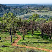 OROVILLE RECREATION The Bidwell Complex, located along the southern shore of Lake Oroville east of the Oroville Dam, is one of the major attractions in the Lake Oroville State Recreation Area. It’s a popular fishing and day use area as well as a base for many boaters. The location has drinking water; eight flush toilets (two are ADA accessible); a grey water sump; boat ramps at high, medium, and low reservoir levels; a telephone; a visitor information station; a full-service marina; and a fish cleaning station. Bidwell Canyon Campground has 75 campsites for either tents or RVs, all with full hookups. Two flush restrooms, piped water, six showers, shade trees, and fire rings with grills are available. Nearby hiking trails include the 4.9-mile Bidwell Canyon Trail and the Wyk Island Trail. The Lake Oroville Visitor Center is open Tuesday through Thursday from 9 a.m. to 5 p.m. and offers visitors numerous educational exhibits, a theater featuring videos about the building of Oroville Dam, walking and hiking trails, and a 47-foot-tall observation tower providing unsurpassed panoramic views of Lake Oroville, the valley, the foothills and Sierra Nevada, and the Sutter Buttes, known as the smallest mountain range in the world. DWR and State Parks maintain over 92 miles of trails in the Oroville area. Trails and their permitted uses (hike, bike, horse, multi), day use areas, boat ramps, and other recreation facilities are featured on DWR’s interactive Lake Oroville Recreation webpage. CURRENT LAKE OPERATIONS Oroville’s reservoir is about 669 feet elevation and storage is approximately 1.03 million acre-feet (MAF), which is 29 percent of its total capacity and 57 percent of the historical average. Temperatures for the coming week will vary between the mid-50s and low-60s, with a slight dip into the 40s possible this Monday. The Feather River releases are currently at 950 cubic feet per second (cfs). Flows through the City of Oroville are 650 cfs with 300 cfs released from the Thermalito Afterbay Outlet (Outlet) for a total of 950 cfs downstream of the Outlet. DWR continues to assess releases to the Feather River daily. The public can track precipitation, snow, reservoir levels, and more at the California Data Exchange Center. The Lake Oroville gage station is identified as “ORO”. All data as of midnight 12/15/2022.  California is in its third year of drought conditions. With water conservation now a way of life in California, everyone is encouraged to find ways to save water. See tips, tools, and ideas on the Save Our Water website. Information about real time local hydrological conditions, forecasts, and water conditions is available on DWR’s new website California Water Watch.
 Winter Outlook Even with the Northern Sierra snowpack measuring 147 percent of normal as of Dec. 8, the Department of Water Resources (DWR) is reminding the public of ongoing drought conditions throughout California. As the state enters its fourth year of drought, California Water Watch shows most of the state is still in moderate, severe, or extreme drought conditions, and the state’s groundwater basins and environments are still stressed from years of severely dry conditions. While early season precipitation totals may be cause for cautious optimism, last year’s above average December was followed by historic dry conditions January through March. This early in the winter, California must proceed with caution and continue to embrace solutions proposed in the administration’s Water Supply Strategy for Adapting to a Hotter, Drier Future. The National Oceanic and Atmospheric Administration (NOAA) is predicting a La Niña winter with dry conditions in Southern California and equal chances of wet or dry conditions in central and northern parts of the state. Early snow totals are only helpful if they translate into runoff into the state's streams, rivers, and reservoirs, particularly in the spring and summer months. DWR is investing in several new tools to both predict and capture runoff, such as investing in additional Airborne Snow Observatory flights and improving runoff forecasting abilities with more sophisticated data collection. While the winter season has started positively, the most important measurement of the year will be April 1, when the snowpack is typically at its highest. You can track precipitation and snowpack data on the California Data Exchange Center website. Lakeside Road Closure The Spillway Day Use Area will be closed to vehicles Tuesday, Dec. 13 and Wednesday, Dec. 14 for utility work along Lakeside Access Road. The gravel spillway ramp will not be affected by the closure and will remain open for use. Trail access to Potters Ravine is available to users from the Dam Crest parking lot by crossing the Spillway road segment that serves as part of the Brad Freeman Bike Trail. This section is open to pedestrians, cyclists, and equestrians. 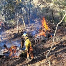 VEGETATION MANAGEMENT CONTINUES IN OROVILLE AREA DWR began vegetation management and debris cleanup activities around the Feather River Fish Hatchery to remove overgrown ladder fuels and create a more wildfire resilient landscape. In addition, CAL FIRE, Butte County Fire Department, Butte County Sheriff, Plumas National Forest, and DWR continue pile burning activities in the Loafer Creek area and along Oro Dam Boulevard East near the Hyatt Powerplant. Vegetation management activities will continue through the winter, weather permitting. Some intermittent trail closures in the Loafer Creek Recreation Area may occur. Trail users are advised to be “safety-aware” and are required to obey posted trail closure signage. Smoke from vegetation removal work has been, and may continue to be, visible in the Oroville area. DWR’s Fuel Load Management Plan (FLMP) works to reduce wildfire risk and increase public safety around Lake Oroville. Previous FLMP projects in the Loafer Creek Recreation Area have been identified as contributing to the slowing of the 2020 North Complex Fire as it approached Kelly Ridge, increasing firefighters’ ability to establish a secure fire line and preventing the fire from progressing. Ongoing management of this critical area remains a high priority for the FLMP.  DWR ISSUES STATE WATER PROJECT ALLOCATIONS DWR issued State Water Project allocations last week amounting to 5 percent of requested supplies for 2023. Existing storage in Lake Oroville is being conserved in the event dry conditions continue. The initial 5 percent allocation would be met by flows from winter storms entering the Delta as well as stored water in San Luis Reservoir. “This early in California’s traditional wet season, water allocations are typically low due to uncertainty in hydrologic forecasting. But the degree to which hotter and drier conditions are reducing runoff into rivers, streams and reservoirs means we have to be prepared for all possible outcomes,” said DWR Director Karla Nemeth. Each year, DWR provides the initial State Water Project allocation by December 1 based on available water storage, projected water supply, and water demands. Allocations are updated monthly as snowpack and runoff information is assessed, with a final allocation typically determined in May or June. Read the full news release on the DWR News webpage. 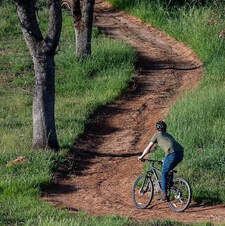 OROVILLE RECREATION Paved boat ramps at Lake Oroville remain temporarily closed due to low lake levels stemming from ongoing drought. DWR and the California Department of Parks and Recreation (State Parks) have provided a gravel launch ramp near the Spillway Boat Ramp until the lake level rises. This gravel launch ramp is open 24-hours a day and may be accessed from the Lakeside Access Road between Oroville Dam and the Spillway Day Use Area and Boat Launch. Four-wheel-drive vehicles are highly recommended – please use at your own risk. The temporary launch ramp is gravel on dirt which becomes slippery when wet, especially during times of heavy usage. To maintain the integrity of the steep ramp, drivers are encouraged to avoid tire spin by engaging vehicles in 4-wheel drive and accelerating slowly when exiting the ramp, with or without a loaded trailer. Both the Lime Saddle and Bidwell Canyon marinas remain open from 8 a.m. until sundown with shuttle service and boat rentals available. Paved boat ramps continue to be available at the Thermalito Afterbay and the Thermalito South Forebay. With continued rising lake levels, the paved Bidwell Canyon III ramp is expected to reopen the week of Dec. 13 with a boarding dock available for users. The Lake Oroville Visitor Center is open Tuesday through Thursday from 9 a.m. to 5 p.m. and offers visitors numerous educational exhibits, a theater featuring videos about the building of Oroville Dam, walking and hiking trails, and a 47-foot-tall observation tower providing unsurpassed panoramic views of Lake Oroville, the valley, the foothills and Sierra Nevada, and the Sutter Buttes, known as the smallest mountain range in the world. DWR and State Parks maintain over 92 miles of trails in the Oroville area. Trails and their permitted uses (hike, bike, horse, multi), day use areas, boat ramps, and other recreation facilities are featured on DWR’s interactive Lake Oroville Recreation webpage. CURRENT LAKE OPERATIONS Oroville’s reservoir is about 662 feet elevation and storage is approximately 985,000 acre-feet (AF), which is 28 percent of its total capacity and 55 percent of the historical average. Rain is again anticipated over the weekend and into early next week with temperatures in the high-40s to low-50s. Weekend rain totals of 2 to 3 inches and wind gusts of 40-45 mph are possible for valley areas. The Feather River releases are currently at 1,000 cubic feet per second (cfs) and will be reduced to 950 cfs Saturday, Dec. 10. Flows through the City of Oroville are 650 cfs with 300 cfs released from the Thermalito Afterbay Outlet (Outlet) for a total of 950 cfs downstream of the Outlet. DWR continues to assess releases to the Feather River daily. The public can track precipitation, snow, reservoir levels, and more at the California Data Exchange Center. The Lake Oroville gage station is identified as “ORO”. All data as of midnight 12/8/2022  California is in its third year of drought conditions. With water conservation now a way of life in California, everyone is encouraged to find ways to save water. See tips, tools, and ideas on the Save Our Water website. Information about real time local hydrological conditions, forecasts, and water conditions is available on DWR’s new website California Water Watch.
 Lake Oroville Boat RampThe Bidwell Canyon Stage III Boat Ramp is now closed due to low lake levels. The Department of Water Resources (DWR) has opened the gravel boat ramp at the Spillway. This ramp may be accessed from the Lakeside Access Road between Oroville Dam and the Spillway Day Use Area and Boat Launch. Four-wheel-drive vehicles are highly recommended – please use at your own risk. The auxiliary ramp is gravel on dirt which becomes slippery when wet, especially during times of heavy usage. To maintain the integrity of the steep ramp, drivers are encouraged to avoid tire spin by engaging vehicles in 4-wheel drive and accelerating slowly when exiting the ramp, with or without a loaded trailer. The Spillway gravel boat ramp is open 24-hours a day. Both the Lime Saddle and Bidwell Canyon marinas remain open from 8 a.m. until sundown with shuttle service and boat rentals available.  FEATHER RIVER FISH HATCHERY Chinook salmon spawning operations have successfully concluded at the Feather River Fish Hatchery. The hatchery collected 9.5 million fall-run, 2.4 million spring-run, and 126,000 inland Lake Oroville Chinook salmon eyed eggs this year. The hatchery’s spawning process collects eggs from female fish and milt (sperm) from male fish to fertilize the eggs. After fertilization, the eggs are placed in incubators to develop and approximately 30-days post fertilization, the healthy eggs develop eyes (eyed egg). After the young salmon further develop in the incubators and reach the “fry” stage, they are transferred to long ponds filled with Feather River water called “raceways” to grow until they are large enough to be returned to the river or planted in locations further downstream to avoid predators. Planting operations for Chinook will occur March through June. The Feather River Fish Hatchery is a California State Water Project (SWP) facility owned and maintained by DWR, which funds hatchery operations. The California Department of Fish and Wildlife (CDFW) operates the hatchery, including fish spawning, rearing, and stocking activities. DWR built the fish hatchery to mitigate the impact of the Oroville Dam on Chinook salmon and steelhead populations because the dam blocks access to natural spawning grounds further upstream. 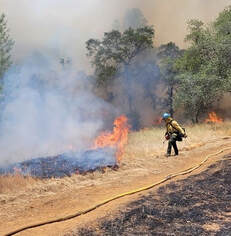 CONTROL BURN AT LOAFER CREEK CAL FIRE, Butte County Fire Department, Plumas National Forest, DWR and California Department of Parks and Recreation (State Parks) are continuing control burn activities in the Loafer Creek Recreation Area near Lake Oroville. The goal of the control burn is to remove overgrown ladder fuels and dead and dying vegetation and minimize ground fuels to create a more wildfire resistant landscape. Multiple burn areas were planned beginning Thursday, Nov. 17 and possibly continuing through the week of Nov. 21, depending on weather and incident activity in Butte County. Some intermittent trail closures in the Loafer Creek Recreation Area may occur. Trail users are advised to be “safety-aware” and obey posted trail closure signage. Smoke from the activity has been, and may continue to be, visible in the Oroville area. DWR’s Fuel Load Management Plan (FLMP) works to reduce wildfire risk and increase public safety around Lake Oroville. Previous FLMP projects in the Loafer Creek Recreation Area have been identified as contributing to the slowing of the 2020 North Complex Fire as it approached Kelly Ridge, increasing firefighters’ ability to establish a secure fire line and preventing the fire from progressing. Ongoing management of this critical area remains a high priority for the FLMP. 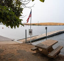 OROVILLE RECREATION Boaters are reminded that power boats are allowed on the Thermalito South Forebay as well as the Thermalito Afterbay. A 5-mph speed limit for all boats is in effect on the Afterbay north of the Highway 162 bridge and near the brood ponds on the east side of the reservoir, with regular boating rules in effect south of the Highway 162 bridge. No motorized boating is allowed in the Thermalito North Forebay. The Monument Hill facility at Thermalito Afterbay provides boat ramp access, restrooms, a picnic area, and beach. The Thermalito South Forebay facility has a two-lane boat ramp, parking, restroom, picnic tables, BBQs, shade trees, and a fish cleaning station. The Lake Oroville Visitor Center is open Tuesday through Thursday, 9 a.m. to 5 p.m. (closed on Thanksgiving Day) and offers visitors numerous educational exhibits, a theater featuring videos about the building of Oroville Dam, walking and hiking trails, and a 47-foot-tall observation tower providing unsurpassed panoramic views of Lake Oroville, the valley, the foothills and Sierra Nevada, and the Sutter Buttes, known as the smallest mountain range in the world. DWR and State Parks maintain over 92 miles of trails in the Oroville area. Trails and their permitted uses (hike, bike, horse, multi), day use areas, boat ramps, and other recreation facilities are featured on DWR’s interactive Lake Oroville Recreation webpage. The Feather River Fish Hatchery is open daily 8 a.m. to 3 p.m. with the Fish Barrier Dam Overlook area and underwater viewing window open sunrise to sunset. CURRENT LAKE OPERATIONS Oroville’s reservoir is about 665 feet elevation and storage is about 1.07 million acre-feet (MAF), which is 28 percent of its total capacity and 57 percent of the historical average. Temperatures are forecasted in the upper-50s to low-to-mid-60s over the weekend and into next week with a slight chance of showers early in the week. The Feather River releases are currently at 1,600 cubic feet per second (cfs) and meet the downstream Delta water quality and outflow needs. Flows through the City of Oroville are 650 cfs with 950 cfs released from the Thermalito Afterbay Outlet (Outlet) for a total of 1,600 cfs downstream of the Outlet. DWR continues to assess releases to the Feather River daily. The public can track precipitation, snow, reservoir levels, and more at the California Data Exchange Center. The Lake Oroville gage station is identified as “ORO”. All data as of midnight 11/17/2022 DWR wishes everyone a Happy Thanksgiving. The Lake Oroville Community Update will return on December 2, 2022.  California is in its third year of drought conditions. With water conservation now a way of life in California, everyone is encouraged to find ways to save water. See tips, tools, and ideas on the Save Our Water website. Information about real time local hydrological conditions, forecasts, and water conditions is available on DWR’s new website California Water Watch.
|
Archives
October 2023
Categories
All
|

 RSS Feed