 July 23, 2021 Drought Information California is no stranger to drought; it is a recurring feature of our climate. Lake Oroville’s low lake levels are a reminder of this cycle of dry and wet years. This year’s drought conditions are being felt across the western United States, with many areas, including California’s Central Valley, identified as being in “extreme drought” - the highest category of drought conditions. DWR has created a “Drought” webpage where definitions, historical trends, current information, and maps of California’s water systems can be found. Links to resources, DWR activities, research, and data are available. Read about how heatwaves are impacting drought conditions on the DWR Updates webpage. The State of California recently launched a website drought.ca.gov. This website will serve as the State’s primary location for public drought news and information. DWR is encouraging water conservation efforts by all Californians. Find out ways you can help by visiting the “Save Our Water” website. New Bald Eagles at Lake Oroville Environmental scientists with the Department of Water Resources (DWR) report they have observed four of the seven bald eagle pairs around Lake Oroville successfully raise seven eaglets this spring. The young eagles have fledged – grown flight feathers and become strong enough to attempt flight – and have been observed taking practice flights around their nests. Lake Oroville and the Feather River area provide ideal habitat for bald eagles. Fish are one of the eagle’s main food sources and large water bodies like Lake Oroville provide a wide variety of fish as well as other favorite food sources such as waterfowl, small birds, and mammals. The many trees and snags (tall dead trees) near water areas provide prime nesting, roosting and hunting locations for the nesting pairs as well as other bald eagles that migrate to and through the area during the winter months. Protecting the area’s year-round bald eagle population living in the Department’s Oroville-Thermalito Complex is the responsibility of the Oroville Field Division’s environmental scientists. The bald eagle is a protected species under the Migratory Bird Treaty Act of 1918 and Bald and Golden Eagle Protection Act of 1940, as well as being listed as a ‘threatened’ species by Congress. DWR’s scientists monitor for and mitigate against threats such as public intrusions, habitat loss, or other impacts to the eagle’s nesting areas. The area has both resident bald eagles as well as eagles who migrate through each year. Boating at Oroville All paved boat ramps on Lake Oroville are now closed due to low lake levels. A single-lane, gravel ramp adjacent to the Bidwell Canyon Stage III ramp is available for boat launching with parking only on the concrete Stage III or Stage II parking lots. Closure of this access may occur at any time as low lake levels and undeveloped site conditions could prevent safe launching of vessels. 4WD vehicles are highly recommended – please use at your own risk. Boat launching and vehicle traffic outside of the gravel path, designated by the traffic cones, is prohibited and may result in immediate closure of the facility. Additionally, the gravel, single-lane boat ramp at the Spillway is open daily from 5 a.m. to 11 p.m. – gates to (and from) the Spillway Boat Ramp area close at 11 p.m. Both of these auxiliary ramps are gravel on dirt which becomes slippery when wet, especially during times of heavy usage. To maintain the integrity of the ramp, drivers are encouraged to avoid tire spin by engaging vehicles in 4-wheel drive and accelerating slowly when exiting the ramp, with or without a loaded trailer. Both the Lime Saddle and Bidwell Canyon marinas remain open from 8 a.m. until sundown with shuttle service and boat rentals available. Power boats are allowed on the Thermalito South Forebay as well as the Thermalito Afterbay. A 5-miles per hour speed limit for all boats is enforced on the Afterbay north of the Highway 162 bridge and near the brood ponds on the east side of the reservoir. No motorized boating is allowed in the Thermalito North Forebay. The Monument Hill facility at Thermalito Afterbay provides boat ramp access, restrooms, a picnic area, and a swim beach. The Thermalito South Forebay facility has a two-lane boat ramp, parking, restroom, picnic tables, BBQs, shade trees, and a fish cleaning station. 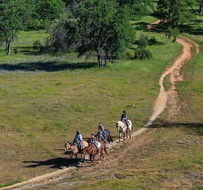 Oroville Recreation Visitors to the Thermalito North Forebay will find a full CA Parks facility with restrooms, picnic areas, a swim beach, and the Forebay Aquatic Center with kayaks, paddle boards, and other watercraft available for rent. Numerous Day Use Area (DUA) facilities with picnic tables and restrooms at Lake Oroville State Recreation Area (LOSRA) are open 8 a.m. to sunset. Bidwell, Lime Saddle, and Loafer Creek Recreation Areas are open 24 hours. The Oroville Dam Crest Road across Oroville Dam is available 5 a.m. to 11 p.m. daily and open to pedestrians and bicyclists 24-hours a day. The Lake Oroville Visitor Center anticipates re-opening later this summer. Visit the California Parks LOSRA webpage for current information on facility status and campground reservations. An interactive map of recreation facilities in DWR’s Oroville-Thermalito Complex is available on DWR’s Lake Oroville Recreation webpage. Information about the 11,000-acre Oroville Wildlife Area is available on the California Department of Fish and Wildlife webpage. Trails Map A map of the trails maintained by DWR, CA Parks, and CDFW is now available at many Oroville locations including LOSRA kiosks, Oroville Wildlife Area office on Oro Dam Boulevard West, the Oroville Area Chamber of Commerce, and Feather River Recreation and Parks District. The map, which folds to pocket size, provides information on permitted trail uses, elevation changes, trail length, and locations of more than 97 miles of trails around Lake Oroville, along the Feather River, Thermalito Forebays and Afterbay, and the Oroville Wildlife Area. Equestrians, bicyclists, and hikers are encouraged to take advantage of this new resource. 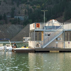 Grebes Nest Receive Help from DWR Western and Clark’s grebes, with their distinctive red eyes, graceful necks and long yellow bills, have returned to the Thermalito Afterbay for their nesting season. The shallow nature of the Afterbay is perfect for these two species of grebes who, along with only a few other aquatic bird species, actually nest on the water. DWR voluntarily restricts the elevation of the Thermalito Afterbay because significant decreases in reservoir elevation could strand the nests out of the water or submerge them if elevations increase. Find more information about the grebes at the DWR Updates webpage. Photos can be found on DWR’s Pixel webpage – enter Grebes in the search bar after creating a user name and password to log in. 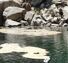 Blue Green Algae Monitoring
DWR environmental scientists regularly monitor for blue-green algae and their toxins during the summer months. There are currently no harmful algal bloom (HAB) advisories for Lake Oroville, the Thermalito Forebay, or the Thermalito Afterbay. Water samples are taken at various locations regularly from Memorial Day through Labor Day and sent to a lab for toxin analysis. If elevated levels of cyanobacteria toxins are found while testing, DWR staff will work with California’s Regional Water Quality Control Board and recreation area managers to notify the public and post advisory signs at affected waterbodies. To learn more about HABs, or to report a HAB visit the Water Board’s website. Current Lake Operations The elevation of Oroville’s reservoir is about 655 feet elevation and storage is about 944,000 acre-feet which is 27 percent of its total capacity and 35 percent of historical average. Currently, in the Northern Sierra Basin, snowpack is also below average at five percent of normal. Warm temperatures ranging from the high-90s to the mid-100s are forecasted this weekend through next week. Total flow to the Feather River is currently at 2,750 cubic feet per second (cfs) for meeting downstream water quality and flow requirements. Flow in the low flow channel, through the City of Oroville, is 2,650 cfs and flow through the Thermalito Afterbay Outlet is 100 cfs. Total releases to the Feather River are assessed daily. Flows through the City of Oroville through the low flow channel may fluctuate throughout the week for fisheries purposes. The public can track precipitation, snow, reservoir levels, and more at the California Data Exchange Center at www.cdec.water.ca.gov. Lake Oroville is identified as “ORO”. All data as of midnight 7/22/2021 ### Know someone who would like to receive Community Updates? They can email their request to oroville@water.ca.gov.  July 16, 2021 Boating at Oroville The lowest paved Bidwell Canyon Stage III Boat Ramp is closed due to low lake levels. A single-lane, gravel ramp adjacent to the Stage III ramp is available for boat launching with parking only on the concrete Stage III or Stage II parking lots. This single-lane gravel access located at Bidwell Canyon will be available for public boat launching until further notice. Closure of this access may occur at any time as low lake levels and undeveloped site conditions could prevent safe launching of vessels. 4WD vehicles are highly recommended – please use at your own risk. Additionally, the gravel, single-lane boat ramp at the Spillway is open daily from 5 a.m. to 11 p.m. – gates to (and from) the Spillway Boat Ramp area close at 11 p.m. Both of these auxiliary ramps are gravel on dirt which becomes slippery when wet, especially during times of heavy usage. To maintain the integrity of the ramp, drivers are encouraged to avoid tire spin by engaging vehicles in 4-wheel drive and accelerating slowly when exiting the ramp, with or without a loaded trailer. Both the Lime Saddle and Bidwell Canyon marinas remain open from 8 a.m. until sundown with shuttle service and boat rentals available. Power boats are allowed on the Thermalito South Forebay as well as the Thermalito Afterbay. A 5-miles per hour speed limit for all boats is enforced on the Afterbay north of the Highway 162 bridge and near the brood ponds on the east side of the reservoir. No motorized boating is allowed in the Thermalito North Forebay. The Monument Hill facility at Thermalito Afterbay provides boat ramp access, restrooms, a picnic area, and a swim beach. The Thermalito South Forebay facility has a two-lane boat ramp, parking, restroom, picnic tables, BBQs, shade trees, and a fish cleaning station. Floating Campsites are closed due limited launching access. Oroville Recreation Visitors to the Thermalito North Forebay will find a full CA Parks facility with restrooms, picnic areas, a swim beach, and the Forebay Aquatic Center with kayaks, paddle boards, and other watercraft available for rent. Numerous Day Use Area (DUA) facilities with picnic tables and restrooms at Lake Oroville State Recreation Area (LOSRA) are open 8 a.m. to sunset. Bidwell, Lime Saddle, and Loafer Creek Recreation Areas are open 24 hours. The Oroville Dam Crest Road across Oroville Dam is available 5 a.m. to 11 p.m. daily and open to pedestrians and bicyclists 24-hours a day. The Lake Oroville Visitor Center anticipates re-opening later this summer. Visit the California Parks LOSRA webpage for current information on facility status and campground reservations. An interactive map of recreation facilities in DWR’s Oroville-Thermalito Complex is available on DWR’s Lake Oroville Recreation webpage. Information about the 11,000-acre Oroville Wildlife Area is available on the California Department of Fish and Wildlife webpage Trails Map A map of the trails maintained by DWR, CA Parks, and CA DFW is now available at many Oroville locations including LOSRA kiosks, Oroville Wildlife Area office on Oro Dam Boulevard West, the Oroville Area Chamber of Commerce, and Feather River Recreation and Parks District. The map is also available online at ExploreButteCounty.com and on DWR’s Lake Oroville Recreation webpage. The map, which folds to pocket size, provides information on permitted trail uses, elevation changes, trail length, and locations of more than 97 miles of trails around Lake Oroville, along the Feather River, Thermalito Forebays and Afterbay, and the Oroville Wildlife Area. Equestrians, bicyclists, and hikers are encouraged to take advantage of this new resource. A full list of locations is available on the Lake Oroville Recreation webpage. 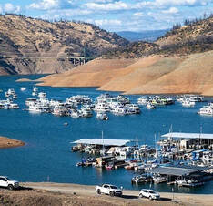 Grebes Nest Receive Help from DWR Western and Clark’s grebes, with their distinctive red eyes, graceful necks and long yellow bills, have returned to the Thermalito Afterbay for their nesting season. The shallow nature of the Afterbay is perfect for these two species of grebes who, along with only a few other aquatic bird species, actually nest on the water. DWR voluntarily restricts the elevation of the Thermalito Afterbay because significant decreases in reservoir elevation could strand the nests out of the water or submerge them if elevations increase. Find more information about the grebes at the DWR Updates webpage. Photos can be found on DWR’s Pixel webpage – enter Grebes in the search bar after creating a user name and password to log in. Drought Information California is no stranger to drought; it is a recurring feature of our climate. Lake Oroville’s low lake levels are a reminder of this cycle of dry and wet years. This year’s drought conditions are being felt across the western United States, with many areas, including California’s Central Valley, identified as being in “extreme drought” - the highest category of drought conditions. DWR has created a “Drought” webpage where definitions, historical trends, current information, and maps of California’s water systems can be found. Links to resources, DWR activities, research, and data are available. Read about how heatwaves are impacting drought conditions on the DWR Updates webpage. The State of California recently launched a new website drought.ca.gov. This website will serve as the State’s primary location for public drought news and information. DWR is encouraging water conservation efforts by all Californians. Find out ways you can help by visiting the “Save Our Water” website. 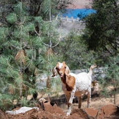 Blue Green Algae Monitoring
DWR environmental scientists regularly monitor for blue-green algae and their toxins during the summer months. There are currently no harmful algal bloom (HAB) advisories for Lake Oroville, the Thermalito Forebay, or the Thermalito Afterbay. Water samples are taken at various locations regularly from Memorial Day through Labor Day and sent to a lab for toxin analysis. If elevated levels of cyanobacteria toxins are found while testing, DWR staff will work with California’s Regional Water Quality Control Board and recreation area managers to notify the public and post advisory signs at affected waterbodies. To learn more about HABs, or to report a HAB visit the Water Board’s website Current Lake Operations The elevation of Oroville’s reservoir is about 665 feet elevation and storage is about 1 million acre-feet -- 27 percent full and 38 percent of historical average. Total flow to the Feather River is currently at 3,000 cubic feet per second (cfs) for meeting downstream water quality and flow requirements. Flow down the low flow channel, through the City of Oroville, is 2,550 cfs and flow through the Thermalito Afterbay Outlet is 450 cfs. Flows through the low flow channel are likely to be adjusted through the week of 7/19 for fisheries purposes. Currently, these flow patterns will hold through the weekend. Current releases are re-assessed on a daily basis. The public can track precipitation, snow, reservoir levels, and more at the California Data Exchange Center at www.cdec.water.ca.gov. Lake Oroville is identified as “ORO”. All data as of midnight 7/15/2021 ### Know someone who would like to receive Community Updates? They can email their request to oroville@water.ca.gov. 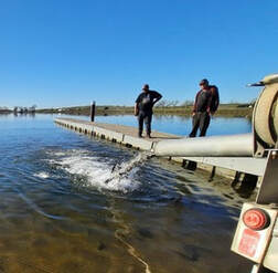 July 9, 2021 Water Quality Working Group In November and December 2020, a multi-agency task force comprised of the State and Central Valley Regional Water Quality Control Boards, Butte County Department of Public Works, California Department of Water Resources (DWR), California Department of Fish and Wildlife, and Governor’s Office of Emergency Services came together as the ‘Watershed Working Group’ to address water quality concerns in the North Complex burn area and downstream. Widespread testing of surface waters throughout the burn scar in Butte and Plumas counties has been completed. Sampling results over the last few months have revealed that while contaminant levels were elevated in some instances, they were lower than anticipated and did not adversely impact drinking water treatment facilities or the quality of drinking water they deliver to their communities. The working group’s agencies will now transition to routine water quality monitoring, which includes monitoring for issues such as Harmful Algal Blooms. Building on the success of the collaboration, this working group will continue to meet quarterly to discuss watershed health and be ready for the upcoming fire season. Read the news release for more information. Saddle Dam Maintenance Lake Oroville State Recreation Area’s Saddle Dam trailhead facility will experience temporary closures from July 13 to July 16. Maintenance work and installation of erosion control measures will require closure of the main and/or auxiliary parking lots as well as the trail across the top of the dam. Trail users are advised to use alternate trailheads at Loafer Creek Recreation Area, Oroville Dam’s Upper Overlook, or the new parking area near the Hyatt Powerplant on Oro Dam Boulevard East. Oroville Recreation The Bidwell Canyon Boat Ramp remains open; however, this ramp is expected to be closed toward the end of the week of July 12, dependent on lake levels. Additionally, the gravel, single-lane boat ramp at the Spillway is open daily from 5 a.m. to 11 p.m. – gates to (and from) the Spillway Boat Ramp area close at 11 p.m. We ask that all people using the gravel ramp engage their vehicle in 4-wheel drive, so they do not spin their tires and damage the ramp. Boat ramp information can be obtained by calling the California Department of Parks and Recreation (CA Parks) at (530) 538-2200 or visiting the Lake Oroville State Recreation Area (LOSRA) website at www.parks.ca.gov/LakeOroville. Both the Lime Saddle and Bidwell Canyon marinas will remain open 8 a.m. until sundown. Visitors to the Thermalito North Forebay will find a full CA Parks facility with restrooms, picnic areas, a swim beach, and the Forebay Aquatic Center with kayaks, paddle boards, and other watercraft available for rent. The Monument Hill facility at the Thermalito Afterbay and the Thermalito South Forebay facility offer boat ramp access, restrooms, picnic areas, and a swim beach at Monument Hill. Power boats are allowed on the Thermalito South Forebay as well as the Thermalito Afterbay. A 5-miles per hour speed limit for all boats is enforced on the Afterbay north of the Highway 162 bridge and near the brood ponds on the east side of the reservoir. More than 97 miles of trails and numerous Day Use Area (DUA) facilities with picnic tables and restrooms at Lake Oroville State Recreation Area (LOSRA) are open 8 a.m. to sunset. Bidwell, Lime Saddle, and Loafer Creek Recreation Areas are open 24 hours. Summer access hours at the Spillway Boat Ramp are 5 a.m. to 11 p.m. daily - gates close at 11 p.m. The Oroville Dam Crest Road across Oroville Dam is available 5 a.m. to 11 p.m. daily and open to pedestrians and bicyclists 24-hours a day. The Lake Oroville Visitor Center anticipates re-opening later this summer. Visit the California Parks LOSRA webpage for current information on facility status and campground reservations. An interactive map of recreation facilities in DWR’s Oroville-Thermalito Complex is available on DWR’s Lake Oroville Recreation webpage. Information about the 11,000-acre Oroville Wildlife Area is available on the California Department of Fish and Wildlife webpage. Drought Information California is no stranger to drought; it is a recurring feature of our climate. Lake Oroville’s low lake levels are a reminder of this cycle of dry and wet years. This year’s drought conditions are being felt across the western United States, with many areas, including California’s Central Valley, identified as being in “extreme drought” - the highest category of drought conditions. DWR has created a “Drought” webpage where definitions, historical trends, current information, and maps of California’s water systems can be found. Links to resources, DWR activities, research, and data are available. Read about how heatwaves are impacting drought conditions on the DWR Updates webpage. The State of California recently launched a new website drought.ca.gov. This website will serve as the State’s primary location for public drought news and information. DWR is encouraging water conservation efforts by all Californians. Find out ways you can help by visiting the “Save Our Water” website.  Blue Green Algae Monitoring
DWR environmental scientists regularly monitor for blue-green algae and their toxins during the summer months. There are currently no harmful algal bloom (HAB) advisories for Lake Oroville, the Thermalito Forebay, or the Thermalito Afterbay. Water samples are taken at various locations regularly from Memorial Day through Labor Day and sent to a lab for toxin analysis. If elevated levels of cyanobacteria toxins are found while testing, DWR staff will work with California’s Regional Water Quality Control Board and recreation area managers to notify the public and post advisory signs at affected waterbodies. To learn more about HABs, or to report a HAB visit the Water Board’s website. Current Lake Operations The elevation of Oroville’s reservoir is about 673 feet elevation and storage is about 1.063 million acre-feet -- 30 percent full and 38 percent of historical average. Currently, in the Northern Sierra Basin, snowpack is also below average at five percent of normal. An excessive heat warning is in effect from Friday to Monday. Temperatures will range between 100 to 115 degrees through this weekend into the early part of the week and high 90s for the rest of the week. Total flow to the Feather River is currently at 3,000 cubic feet per second (cfs) for meeting downstream water quality and flow requirements. Flow down the low flow channel, through the City of Oroville, is 1,550 cfs and flow through the Thermalito Afterbay Outlet is 1,450 cfs. Currently, these flow patterns will hold through the weekend. Current releases are re-assessed on a daily basis. The public can track precipitation, snow, reservoir levels, and more at the California Data Exchange Center at www.cdec.water.ca.gov. Lake Oroville is identified as “ORO”. ### Know someone who would like to receive Community Updates? They can email their request to oroville@water.ca.gov.  July 2, 2021 Fourth of July Fireworks at Oroville The Oroville Rotary Club will be holding a Fourth of July celebration at the Oroville Municipal Airport on Independence Day. While there will not be public access to the airport facility for the fireworks show, public areas around the airport will be accessible by personal vehicle to tailgate during the event. The nearby Clay Pit State Vehicle Recreation Area will be closed for safety reasons. A fly-in event in the morning at the airport will also take place. The fireworks show will begin 30 minutes after sunset. Information on suggested viewing locations and other event information is available on the Oroville Area Chamber of Commerce website at: https://www.visitoroville.com/oroville-fireworks.html. Photo: On the North Forebay in Oroville waiting for fireworks to start. Oroville Recreation The Bidwell Canyon Boat Ramp will be open over the Fourth of July holiday weekend with future status dependent on lake levels. The gravel, single-lane, 4-wheel drive only, boat ramp at the Spillway opens this afternoon, July 2. Boat ramp information can be obtained by calling the California Department of Parks and Recreation (CA Parks) at (530) 538-2200 or visiting the Lake Oroville State Recreation Area (LOSRA) website at www.parks.ca.gov/LakeOroville. Both the Lime Saddle and Bidwell Canyon marinas will remain open 8 a.m. until sundown. Summer access hours of 5 a.m. to 11 p.m. daily is now in effect for the Spillway Boat Ramp Area - gates close at 11 p.m. The Oroville Dam Crest Road across Oroville Dam is available 5 a.m. to 11 p.m. daily and open to pedestrians and bicyclists 24-hours a day. The Lake Oroville Visitor Center anticipates re-opening later this summer. Visitors to the Thermalito North Forebay will find a full CA Parks facility with restrooms, picnic areas, a swim beach, and the Forebay Aquatic Center with kayaks, paddle boards, and other watercraft available for rent. The Monument Hill facility at the Thermalito Afterbay also provides boat ramp access, restrooms, a picnic area, and a swim beach. Visit the California Parks LOSRA webpage for current information on facility status and campground reservations. An interactive map of recreation facilities in DWR’s Oroville-Thermalito Complex is available on DWR’s Lake Oroville Recreation webpage at https://water.ca.gov/What-We-Do/Recreation/Lake-Oroville-Recreation. Information about the 11,000-acre Oroville Wildlife Area is available on the California Department of Fish and Wildlife webpage at https://wildlife.ca.gov/Lands/Places-to-Visit/Oroville-WA. Photo: Camping at the Lake Oroville State Recreation Area Lake Oroville Visitor Center CA Parks and DWR have issued a news release announcing both will be offering expanded educational opportunities at the Lake Oroville Visitor Center and State Recreation Area in the coming months. DWR is exclusively managing the Visitor Center as CA Parks transitions its educational programming away from the Visitor Center to various LOSRA locations as it further expands outdoor educational programs to educate visitors and provide high-quality outdoor recreation opportunities. DWR is recruiting additional staff to support operations and to assist with enhanced educational opportunities and informational displays at the Visitor Center that highlight California’s water delivery system and the importance of water in our lives. The Visitor Center will reopen later this year. 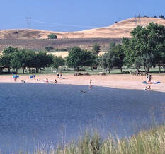 Oroville Wildlife Area Habitat Project The sunflowers and safflowers planted this spring on 60 acres of the Oroville Wildlife Area (OWA) are growing taller. The nearly 12,000-acre OWA in Butte County is a popular stopping place on the Pacific Flyway for migrating and native birds. Managed by the California Department of Fish and Wildlife (CDFW) for the Department of Water Resources (DWR), the OWA also includes DWR’s Thermalito Afterbay reservoir, a prime habitat for migrating waterfowl and several endangered species. CDFW farms more than 300 acres of grains, grasses, and flowering plants in the OWA to provide food (forage), shelter, and nesting cover for migratory and native birds. Recently, 60 acres in various locations around the Thermalito Afterbay were planted with sunflowers and safflowers. Read more about CDFW’s 50 years of using dry-land farming techniques to add diversity to the area’s wildlife habitat on the DWR Updates webpage. DWR will be tracking the success of these 60 acres over the summer and photos can be found on DWR’s public photo sharing site by using the search term “Oroville Wildlife Area Planting”. Photo: Sunflowers grow in the Oroville Wildlife Area to provide forage and habitat for wildlife and birds. Drought Information California is no stranger to drought; it is a recurring feature of our climate. Lake Oroville’s low lake levels are a reminder of this cycle of dry and wet years. This year’s drought conditions are being felt across the western United States, with many areas, including California’s Central Valley, identified as being in “extreme drought” - the highest category of drought conditions. DWR has created a “Drought” webpage where definitions, historical trends, current information, and maps of California’s water systems can be found. Links to resources, DWR activities, research, and data are available. Read about how heatwaves are impacting drought conditions on the DWR Updates webpage. DWR is encouraging water conservation efforts by all Californians. Find out ways you can help by visiting the “Save Our Water” website. 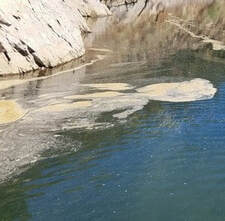 Blue Green Algae Monitoring
DWR environmental scientists regularly monitor for blue-green algae and their toxins during the summer months. There are currently no harmful algal bloom (HAB) advisories for Lake Oroville, the Thermalito Forebay, or the Thermalito Afterbay. Water samples are taken at various locations regularly from Memorial Day through Labor Day and sent to a lab for toxin analysis. If elevated levels of cyanobacteria toxins are found while testing, DWR staff will work with California’s Regional Water Quality Control Board and recreation area managers to notify the public and post advisory signs at affected waterbodies. To learn more about HABs, or to report a HAB visit the Water Board’s website. Photo: Algal bloom on Lake Oroville's West Branch Current Lake Operations The elevation of Oroville’s reservoir is about 681 feet elevation and storage is about 1.12 million acre-feet -- 32 percent full and 39 percent of historical average. Currently, in the Northern Sierra Basin, snowpack is also below average at five percent of normal. Warm temperatures in the ranging in the high 90s and low 100s continue this weekend through next week. Total flow to the Feather River is currently at 3,000 cubic feet per second (cfs) for meeting downstream water quality and flow requirements. Flow down the low flow channel, through the City of Oroville, is 1,550 cfs and flow through the Thermalito Afterbay Outlet is 1,450 cfs. Currently, these flow patterns will hold through the weekend. Current releases are re-assessed on a daily basis. The public can track precipitation, snow, reservoir levels, and more at the California Data Exchange Center at www.cdec.water.ca.gov. Lake Oroville is identified as “ORO”. All data as of midnight 7/1/2021 ### Know someone who would like to receive Community Updates? They can email their request to oroville@water.ca.gov. |
Archives
October 2023
Categories
All
|

 RSS Feed