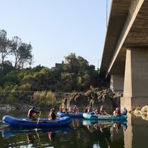
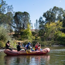
 Feather River Floating Classrooms Spend time on the beautiful Feather River this fall and join Department of Water Resources (DWR) scientists for educational floats each Saturday through Nov. 11. Rafting trips will float through Feather River spawning habitat while DWR scientists provide information on Chinook salmon conservation efforts, ongoing and planned research, and restoration and monitoring projects. Each Saturday will have three floating classroom sessions with limited seats. Weekend sessions support free floating classroom events for local schools. Reserve your Floating Classroom Tour Tickets on Eventbrite. 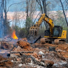 VEGETATION MANAGEMENT ACTIVITIES DWR and CAL FIRE have resumed vegetation management activities in the Loafer Creek Recreation Area. CAL FIRE hand crews and heavy equipment operators will be working throughout Loafer Creek and along HWY 162 (Oro Quincy Highway) for the next several months. Smoke from pile burning activities will be visible in the Oroville area. The goal of this project is to remove overgrown ladder fuels, dead and dying vegetation, and minimize ground fuels to create a more wildfire resilient landscape. DWR’s Fuel Load Management Plan works to reduce wildfire risk, increase public safety, and enhance forest health around the Lake Oroville area. Ongoing vegetation management of this critical area remains a high priority for DWR and its partners at CAL FIRE, Butte County Fire Department, Butte County Sheriff’s Office, California Conservation Corps (CCC), California Department of Parks and Recreation (State Parks), and the Butte County Fire Safe Council. Vegetation management activities are ramping up for the season and will continue through Spring 2024 as weather conditions permit and crews are available.  CALIFORNIA WATER PLAN 2023 From severe, multi-year droughts to sudden flooding, California is experiencing the intensifying impacts of climate change. To better prepare and plan for a future with climate extremes, DWR has released the Public Review Draft of California Water Plan Update 2023. For decades, the California Water Plan has served and evolved as a strategic blueprint for managing and developing the state's water resources. This comprehensive plan is meant to guide water managers, including water districts, cities, counties, and Tribal communities. Every five years the California Water Plan is updated, as mandated by the State Water Code, to reflect current water conditions and State government priorities. These updates are shaped by various factors, including the Water Resilience Portfolio, input from interested parties, state needs, and the Governor's commitment to climate action, as demonstrated in California's Water Supply Strategy: Adapting to a Hotter, Drier Future. Public comments on the Draft California Water Plan Update 2023 are being accepted through Oct. 19, 2023. Comments may be submitted through an online form or to [email protected].  NEW SPILLWAY DAY USE AREA HOURS With the end of summer and shorter daylight hours approaching, the Spillway Day Use Area has reduced hours. The Spillway Day Use Area and Boat Ramp is now open daily from 6 a.m. to 8 p.m. These reduced hours will remain in effect through April 30, 2024. Vehicles may remain in the parking lot overnight but will be prohibited from exiting. All vehicles and trailers heading to the Spillway Day Use Area are subject to inspection by the California Highway Patrol (CHP) for security purposes. There are three other boat ramps at Lake Oroville that are open 24 hours a day and do not entail CHP inspections: Bidwell Canyon, Loafer Point, and Lime Saddle. 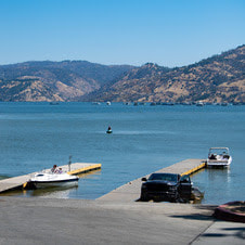 OROVILLE RECREATION
DWR biologists are using the Feather River Fish Monitoring Station to determine abundance, run timing, and origin (hatchery or natural) of steelhead and Chinook salmon populations. This information will improve management of these important fish populations. Upstream migrating fish totals between Sept. 11 and Sept. 24:
The Lake Oroville Visitor Center is open seven days a week from 9 a.m. to 5 p.m. Staffed by knowledgeable guides, the Visitor Center features interpretive displays on Oroville Dam, area geology, wildlife and habitat, hydroelectric power, and cultural and historical artifacts. View videos in the theater about the construction of Oroville Dam, walk or hike along nearby trails, and visit the 47-foot-tall observation tower that provides unsurpassed panoramic views of surrounding areas. Free guided tours for school and community groups are available by reservation. Parking and admission to the Visitor Center are free. CURRENT LAKE OPERATIONS Lake Oroville is at 831 feet elevation and storage is approximately 2.56 million acre-feet (MAF), which is 72 percent of its total capacity and 135 percent of the historical average. Feather River releases are being reduced to 4,000 cubic feet per second (cfs) through Tuesday, Oct. 10. Flows through the City of Oroville remain at 650 cfs and releases from the Thermalito Afterbay Outlet (Outlet) are being reduced to 3,350 cfs for a total of 4,000 cfs downstream of the Outlet. Further reductions are currently anticipated next week. DWR continues to assess releases to the Feather River daily. DWR’s Water Operations division has begun adjusting reservoir levels in accordance with the U.S. Army Corps of Engineers Water Control Manual. This is done each year in preparation for the winter season to provide flood control protection to downstream communities and obtain additional space in the lake for increased storm runoff. Additionally, DWR’s Water Operations division monitors forecasts closely to predict incoming storm impacts and determine whether to release additional water to account for higher estimated inflows. Visitors to Oroville Dam may also notice minor amounts of water flowing from drains built into the emergency spillway, which is normal and expected with the emergency spillway design. The dam and emergency spillway continue to operate as intended. The public can track precipitation, snow, reservoir levels, and more at the California Data Exchange Center. The Lake Oroville gage station is identified as “ORO.” All data as of midnight 10/5/2023. CALIFORNIA DEPARTMENT OF WATER RESOURCES 715 P Street Sacramento, CA 95814 Call our general information line at 916-820-8142 or email us at [email protected] 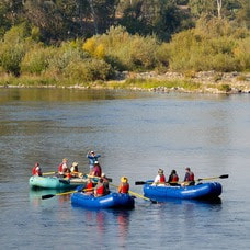 Feather River Floating Classrooms Spend time on the beautiful Feather River this fall and join Department of Water Resources (DWR) scientists for educational floats each Saturday through Nov. 11. Rafting trips will float through Feather River spawning habitat while DWR scientists provide information on Chinook salmon conservation efforts, ongoing and planned research, and restoration and monitoring projects. Each Saturday will have three floating classroom sessions with limited seats. Weekend sessions support free floating classroom events for local schools. Reserve your Floating Classroom Tour Tickets on Eventbrite.  NEW SPILLWAY DAY USE AREA HOURS With the end of summer and shorter daylight hours approaching, the Spillway Day Use Area will have reduced hours. Beginning Sunday, Oct. 1, the Spillway Day Use Area and Boat Ramp will be open daily from 6 a.m. to 8 p.m. These reduced hours will remain in effect through April 30, 2024. Vehicles may remain in the parking lot overnight but will be prohibited from exiting. All vehicles and trailers heading to the Spillway Day Use Area are subject to inspection by the California Highway Patrol (CHP) for security purposes. There are three other boat ramps at Lake Oroville that are open 24 hours a day and do not entail CHP inspections: Bidwell Canyon, Loafer Point, and Lime Saddle. 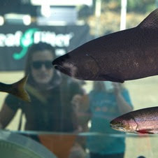 OROVILLE SALMON FESTIVAL DWR had a great time supporting the City of Oroville’s Salmon Festival celebrating the migration of native Chinook salmon in the Feather River. Thank you to everyone who stopped by our educational booth and took a free tour of the Feather River Fish Hatchery. DWR staff estimated that approximately 600 children and adults participated in DWR-led tours of the Hatchery, where Chinook salmon and steelhead are raised to improve fisheries populations throughout the state. DWR also partnered with the Oroville State Theater to showcase videos about efforts to support vital salmon habitat restoration, fisheries health, and population growth. Many also saw salmon up close as they paddled down the river with rafting tours featuring DWR biologists who shared information about the salmonid life cycle and Feather River. Tickets for this unique experience are still available. Reserve your Floating Classroom Tour Tickets on Eventbrite. To learn more about what DWR is doing year-round to support Feather River fish populations, visit our Storymap webpage. 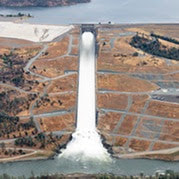 MAINTENANCE WORK ON MAIN SPILLWAY UNDERWAY DWR is performing routine concrete and sealant repair work on localized areas of the spillway identified during annual inspections. While the main spillway continues to perform well and operate as designed, periodic concrete and sealant repairs of the spillway are expected due to seasonal temperature variations, spillway releases, and sun exposure. In 2023, Oroville Dam’s main spillway has passed over 2,370,000 acre-feet of water – approximately 67 percent of the capacity of Lake Oroville – with flows up to 36,000 cubic feet per second this spring. Construction work is expected to continue through Nov. 15, but is dependent on weather and Oroville Dam operations. DWR will monitor reservoir levels and weather forecasts closely and will complete repair work early if spillway releases are required for flood control. Approximately 500 square-feet of total concrete repairs are anticipated, representing less than 0.1 percent of the spillway’s surface. DWR will also replace joint sealant at select chute slab and wall joints that wear over time due to the spillway’s environment and inspect 51,000 feet of piping that supports the spillway’s improved drainage system. The spillway was rebuilt to the highest engineering and safety standards with oversight and guidance by the Federal Energy Regulatory Commission (FERC), Division of Safety of Dams (DSOD), and an independent board of consultants. DWR performed a significant amount of inspection and testing throughout construction to verify compliance with project specifications. DWR also provides regular updates to the Oroville Dam Citizens Advisory Commission, a public forum for discussing operations, maintenance, and public safety activities at Oroville Dam and its facilities. 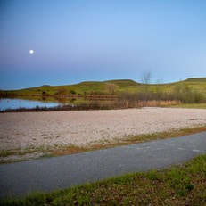 OROVILLE RECREATION
DWR biologists are using the Feather River Fish Monitoring Station to determine abundance, run timing, and origin (hatchery or natural) of steelhead and Chinook salmon populations. This information will improve management of these important fish populations. Monitoring counts between Sept. 11 and Sept. 20 show a net total of 1,840 Chinook salmon and 52 steelhead that have passed upstream. DWR, the California Department of Parks and Recreation, and DFW maintain over 92 miles of trails in the Oroville area. An interactive map of recreation facilities, including open boat ramps, and their permitted uses (hike, bike, horse, multi) is available on DWR’s Lake Oroville Recreation webpage. A paper trail map is available at various locations, including most entrance kiosks and the Lake Oroville Visitor Center. The marinas at Bidwell Canyon and Lime Saddle are open daily and provide a variety of services including a convenience store, gas, and boat rentals. The Lake Oroville Visitor Center is open seven days a week from 9 a.m. to 5 p.m. Staffed by knowledgeable guides, the Visitor Center features interpretive displays on Oroville Dam, area geology, wildlife and habitat, hydroelectric power, and cultural and historical artifacts. View videos in the theater about the construction of Oroville Dam, walk or hike along nearby trails, and visit the 47-foot-tall observation tower that provides unsurpassed panoramic views of surrounding areas. Free guided tours for school and community groups are available by reservation. Parking and admission to the Visitor Center are free. CURRENT LAKE OPERATIONS Lake Oroville is at 835 feet elevation and storage is approximately 2.62 million acre-feet (MAF), which is 74 percent of its total capacity and 136 percent of the historical average. Feather River releases are currently at 7,500 cubic feet per second (cfs). Flows through the City of Oroville are at 650 cfs and releases from the Thermalito Afterbay Outlet (Outlet) are at 6,850 cfs for a total of 7,500 cfs downstream of the Outlet. DWR continues to assess releases to the Feather River daily. DWR’s Water Operations division has begun adjusting reservoir levels in accordance with the U.S. Army Corps of Engineers Water Control Manual. This is done each year in preparation for the winter season to provide flood control protection to downstream communities and obtain additional space in the lake for increased storm runoff. Additionally, DWR’s Water Operations division monitors forecasts closely to predict incoming storm impacts and determine whether to release additional water to account for higher estimated inflows. Visitors to Oroville Dam may also notice minor amounts of water flowing from drains built into the emergency spillway, which is normal and expected with the emergency spillway design. The dam and emergency spillway continue to operate as intended. The public can track precipitation, snow, reservoir levels, and more at the California Data Exchange Center. The Lake Oroville gage station is identified as “ORO.” All data as of midnight 9/28/2023. CALIFORNIA DEPARTMENT OF WATER RESOURCES 715 P Street Sacramento, CA 95814 Call our general information line at 916-820-8142 or email us at [email protected]  Feather River Fish Monitoring Station DWR has completed the installation of a fish monitoring station in the Feather River about five miles downstream of Oroville. The fish monitoring structure guides fish past an underwater video camera that allows biologists to review footage and determine abundance, run timing, and origin (hatchery or natural) of steelhead and Chinook salmon populations. This information will improve management of these important fish populations in the Feather River and at the Feather River Fish Hatchery. There are several of these structures already operating in rivers throughout California and they are designed to facilitate safe boat passage. Informational signs will be posted at boat launches and near the monitoring station to assist river users in navigating over the structure. Those in more portable water vessels also have the option to use the riverbank and walk around the monitoring station. The fish monitoring station is located approximately 6.5 miles downstream of the Feather River Fish Hatchery, 4.5 miles downstream of the Riverbend Park Boat Ramp, and 1.5 miles upstream of the Thermalito Afterbay River Outlet Boat Ramp. 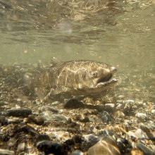 SALMON HABITAT PROJECT DWR began construction this week on a salmonid habitat improvement project in the Feather River near the Feather River Fish Hatchery and Bedrock Park in Oroville. In development since 2021, the project consists of in-river spawning gravel placement to improve existing spawning habitat sites and will also improve habitat accessibility to existing side channels by excavating and redistributing accumulated streambed material. Migratory fish species such as Chinook salmon and steelhead trout rely on Feather River spawning habitats along the low-flow channel, where most spawning activity occurs. Female salmonids lay their eggs in nests called “redds” using coarse sediment, such as clean, rounded gravel. Starting Monday, Aug. 7, people floating down the Feather River in this area may encounter “traffic control” along the waterway. Construction flaggers with stop signs will be stationed in the river to alert water users of nearby heavy construction equipment and direct water traffic safely through the construction zone. River recreationists are encouraged to remain alert when passing through work zones. DWR’s project is placing approximately 8,000 cubic yards of gravel at multiple locations to improve spawning conditions. The project is primarily funded by two grants: the State of California Natural Resource Agency Prop 68 – Protecting California’s Rivers, Streams and Watershed Grant Program, and the Central Valley Project Improvement Act – Fish and Wildlife Restoration Activities supported by the U.S. Department of Interior. Previous DWR Feather River spawning restoration projects included the placement of 8,300 cubic yards of spawning gravel in 2014 and another 5,000 cubic yards in 2017. In-river work for the project is expected to last through the end of August.  OROVILLE RECREATION
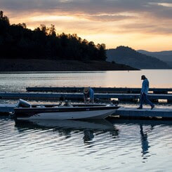
Visitors continue to enjoy the abundant recreation facilities at the Lake Oroville State Recreation Area. All major boat ramps are open and, with numerous launching lanes and available parking, wait times are at a minimum. Floating campsite reservations remain popular with campgrounds throughout the Recreation Area also offering close access for water activities. The marinas at Bidwell Canyon and Lime Saddle are open daily and provide a variety of services including a convenience store, gas, and boat rentals. The North Forebay Aquatic Center has several summertime programs, and the Thermalito Afterbay has been a popular recreation spot for water skiers, jet skiers, and anglers. The Lake Oroville Visitor Center is open Monday through Friday between 9 a.m. and 5 p.m. The Visitor Center offers numerous educational exhibits, a theater featuring videos about the building of Oroville Dam, walking and hiking trails, and a 47-foot-tall observation tower providing unsurpassed panoramic views. DWR, State Parks, and the California Department of Fish and Wildlife also maintain over 92 miles of trails in the Oroville area. An interactive map of recreation facilities, including open boat ramps, and their permitted uses (hike, bike, horse, multi) is available on DWR’s Lake Oroville Recreation webpage. A paper trail map is available at various locations, including most entrance kiosks and the Visitor Center. CURRENT LAKE OPERATIONS Lake Oroville is at 877 feet elevation and storage is approximately 3.19 million acre-feet (MAF), which is 90 percent of its total capacity and 137 percent of the historical average. Feather River releases are currently at 6,500 cfs. Flows through the City of Oroville are at 2,000 cfs and releases from the Thermalito Afterbay Outlet (Outlet) are at 4,500 cfs for a total of 6,500 cfs downstream of the Outlet. Further increases in flow through the City of Oroville are expected next week for fisheries purposes. DWR continues to assess releases to the Feather River daily. DWR will use the main spillway intermittently this summer for water releases to manage storage within the Oroville complex or maintain Feather River temperature levels during ongoing river valve outlet system work near the Hyatt Powerplant. When the main spillway is not in use, water may still be seen on the main spillway outlet as the seals on the eight radial gates are not designed to be watertight. The gate seals do not play a role in the structural integrity of the gates, which continue to operate as intended. DWR periodically maintains and adjusts the seals during low-reservoir conditions to improve their sealing capability. The radial gates were also last inspected and tested in Dec. 2022. Visitors to Oroville Dam may also notice minor amounts of water flowing from drains built into the emergency spillway. As the reservoir level has increased, water flow from the drains has increased, which is normal and expected with the emergency spillway design. The dam and emergency spillway continue to operate as intended. The public can track precipitation, snow, reservoir levels, and more at the California Data Exchange Center. The Lake Oroville gage station is identified as “ORO”. All data as of midnight 8/3/2023.  Lake Oroville Water Operations The Department of Water Resources (DWR) continues releases from Lake Oroville to manage storage levels along with water quality and flows through the Sacramento-San Joaquin Delta. Total releases to the Feather River amount to 7,500 cubic feet per second (cfs), with adjustments being made as needed. Over the past week, inflows into Lake Oroville have been in the range of 2,600 to 2,900 cfs and are projected to remain at that level for the coming week. DWR will use the main spillway intermittently this summer for water releases to manage storage within the Oroville complex or maintain Feather River temperature levels during ongoing river valve outlet system work near the Hyatt Powerplant. When the main spillway is not in use, water may still be seen on the main spillway outlet as the seals on the eight radial gates are not designed to be watertight. The gate seals do not play a role in the structural integrity of the gates, which continue to operate as intended. DWR periodically maintains and adjusts the seals during low-reservoir conditions to improve their sealing capability. The radial gates were also last inspected and tested in Dec. 2022. Visitors to Oroville Dam may also notice minor amounts of water flowing from drains built into the emergency spillway. As the reservoir level has increased, water flow from the drains has increased, which is normal and expected with the emergency spillway design. The dam and emergency spillway continue to operate as intended. Driftwood and other floating debris on Lake Oroville are expected due to continued water inflows from tributaries and a high lake level, in combination with past wildfires impacting the watershed. Since January, DWR and California Department of Parks and Recreation (State Parks) staff have been collecting, containing, and pulling pieces of wood out of the lake and away from boat launch ramps using boom lines. However, boaters, water skiers, and other water recreationists should take precautions when operating boats on Lake Oroville and should remain alert for floating debris. The Lake Oroville reservoir is the largest storage facility in the State Water Project (SWP) and supports environmental and water delivery needs to 27 million Californians and reduces flood risks to downstream communities. DWR continues to closely monitor lake levels and will adjust releases accordingly to optimize operations for water storage and environmental protection while allowing for carryover storage into next year.  SALMON HABITAT PROJECT DWR will begin construction July 31 on a salmonid habitat improvement project in the Feather River near the Feather River Fish Hatchery and Bedrock Park in Oroville. In development since 2021, the project consists of in-river spawning gravel placement to improve existing spawning habitat sites and will also improve habitat accessibility to existing side channels by excavating and redistributing accumulated streambed material. Migratory fish species such as Chinook salmon and steelhead trout rely on Feather River spawning habitats along the low-flow channel, where most spawning activity occurs. Female salmonids lay their eggs in nests called “redds” using coarse sediment, such as clean, rounded gravel. DWR’s project will place approximately 8,000 cubic yards of gravel at multiple locations to improve spawning conditions. The project is primarily funded by two grants: the State of California Natural Resource Agency Prop 68 – Protecting California’s Rivers, Streams and Watershed Grant Program, and the Central Valley Project Improvement Act – Fish and Wildlife Restoration Activities supported by the U.S. Department of Interior. Previous DWR Feather River spawning restoration projects included the placement of 8,300 cubic yards of spawning gravel in 2014 and another 5,000 cubic yards in 2017. In-river work for the project is expected to last through the end of August. CAR-TOP BOAT LAUNCHES State Parks has reopened the Nelson Bar Car-Top Boat Launch due to receding water levels at Lake Oroville. The Nelson Bar Car-Top Boat Launch is open daily from 8 a.m. to sunset and is located along the west branch of the north fork arm of Lake Oroville; accessible via Pentz Road and Lime Saddle Road. There are three other car-top boat launches open at Lake Oroville – Vinton Gulch, Stringtown and Foreman Creek. 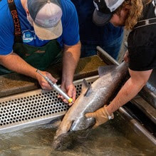 SUPPORTING SALMON HEALTH California’s Central Valley is home to four runs of Chinook salmon: spring, fall, late-fall, and winter. From climate change to loss of habitat, salmon are faced with a number of threats, and one of the latest to emerge in recent years is a thiamine deficiency. Thiamine is vitamin B1, and it is a crucial vitamin for neurons and immune systems in salmon. Evidence of a thiamine deficiency in spring-run salmon started showing up in 2019. Salmon typically get adequate levels of thiamine from their food supply in the ocean, but for the last several years that hasn’t been happening due to changes in the ocean food web. Spring-run are unique from other runs of salmon because they return to rivers in the spring and spend the summer in cold water pools before spawning early in the fall. In the Feather River, many of these fish enter the Feather River Fish Hatchery, where they are tagged for identification and released back into the river. In 2021, DWR started injecting these fish with thiamine as they passed through the hatchery in order to decrease thiamine-related mortality of their offspring. Visit our YouTube channel for a video about DWR’s collaboration to help spring-run Chinook salmon. 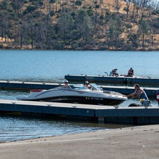 OROVILLE RECREATION
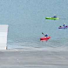
The Lake Oroville Visitor Center is open Monday through Friday between 9 a.m. and 5 p.m. The Visitor Center offers numerous educational exhibits, a theater featuring videos about the building of Oroville Dam, walking and hiking trails, and a 47-foot-tall observation tower providing unsurpassed panoramic views. DWR, State Parks, and the California Department of Fish and Wildlife also maintain over 92 miles of trails in the Oroville area. An interactive map of recreation facilities, including open boat ramps, and their permitted uses (hike, bike, horse, multi) is available on DWR’s Lake Oroville Recreation webpage. A paper trail map is available at various locations, including most entrance kiosks and the Visitor Center. The marinas at Bidwell Canyon and Lime Saddle are open daily and provide a variety of services including a convenience store, gas, and boat rentals. CURRENT LAKE OPERATIONS Lake Oroville is at 885 feet elevation and storage is approximately 3.3 million acre-feet (MAF), which is 93 percent of its total capacity and 138 percent of the historical average. Feather River releases were increased to 7,500 cfs today. Flows through the City of Oroville are at 950 cfs and will decrease to 650 cfs on Saturday. Releases from the Thermalito Afterbay Outlet (Outlet) will increase to 6,850 cfs by Saturday for a total of 7,500 cfs downstream of the Outlet. DWR continues to assess releases to the Feather River daily. The public can track precipitation, snow, reservoir levels, and more at the California Data Exchange Center. The Lake Oroville gage station is identified as “ORO”. All data as of midnight 7/27/2023.  Lake Oroville Water Operations The Department of Water Resources (DWR) continues releases from Lake Oroville to manage storage levels along with water quality and flows through the Sacramento-San Joaquin Delta. Total releases to the Feather River amount to 5,000 cubic feet per second (cfs), with adjustments being made as needed. Over the past week, inflows into Lake Oroville have been in the range of 3,600 to 4,000 cfs and are projected to be lower for the coming week. DWR is currently using the main spillway for water releases to manage storage within the Oroville complex and maintain Feather River temperature levels during ongoing river valve outlet system work near the Hyatt Powerplant. When the main spillway is not in use water may still be seen on the main spillway outlet as the seals on the eight radial gates are not designed to be watertight. The gate seals do not play a role in the structural integrity of the gates, which continue to operate as intended. DWR periodically maintains and adjusts the seals during low-reservoir conditions to improve their sealing capability. The radial gates were also last inspected and tested in Dec. 2022. Visitors to Oroville Dam may also notice minor amounts of water flowing from drains built into the emergency spillway. As the reservoir level has increased, water flow from the drains has increased, which is normal and expected with the emergency spillway design. The dam and emergency spillway continue to operate as intended. Driftwood and other floating debris on Lake Oroville are expected due to continued water inflows from tributaries and a high lake level, in combination with past wildfires impacting the watershed. Since January, DWR and California Department of Parks and Recreation (State Parks) staff have been collecting, containing, and pulling pieces of wood out of the lake and away from boat launch ramps using boom lines. However, boaters, water skiers, and other water recreationists should take precautions when operating boats on Lake Oroville and should remain alert for floating debris. The Lake Oroville reservoir is the largest storage facility in the State Water Project (SWP) and supports environmental and water delivery needs to 27 million Californians and reduces flood risks to downstream communities. DWR continues to closely monitor lake levels and will adjust releases accordingly to optimize operations for water storage and environmental protection while allowing for carryover storage into next year. 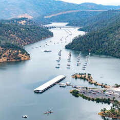 A RESTORATIVE WINTER At only 29 percent capacity in December 2022, the Lake Oroville reservoir has made an astounding recovery thanks to numerous atmospheric rivers that delivered heavy amounts of rain and snow to California this winter. Lake Oroville gained more than 2.5 million acre-feet of water after Dec. 1, bringing the reservoir to its full capacity – a marked difference in just seven months. See the difference in water levels between Dec. 21, 2022, when the reservoir was at 29 percent capacity, to July 3, 2023, with Lake Oroville at 99 percent capacity. It’s a welcome sight!  OROVILLE RECREATION A full reservoir delivers numerous opportunities for water recreation at Lake Oroville and is also a prime location to beat 100-degree weather. Water enthusiasts were out in full force at Lake Oroville during the week of July 4. Whether you enjoy swimming, boating, kayaking, jet skiing, fishing, or several other water activities, don’t miss your opportunity to relax and recreate at the lake! The marinas at Bidwell Canyon and Lime Saddle are open daily and provide a variety of services such as a shuttle and boat rentals. DWR, State Parks, and the California Department of Fish and Wildlife maintain over 92 miles of trails in the Oroville area. An interactive map of recreation facilities, including open boat ramps, and their permitted uses (hike, bike, horse, multi) is available on DWR’s Lake Oroville Recreation webpage. A paper trail map is available at various locations, including most entrance kiosks and the Visitor Center. The Lake Oroville Visitor Center is open Monday through Friday between 9 a.m. and 5 p.m. The Visitor Center offers numerous educational exhibits, a theater featuring videos about the building of Oroville Dam, walking and hiking trails, and a 47-foot-tall observation tower providing unsurpassed panoramic views. 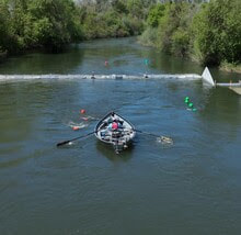 FEATHER RIVER FISH MONITORING STATION DWR is continuing construction activities for a fish monitoring station project in the Feather River in Oroville. The fish monitoring station will provide information on abundance, run timing, and origin (hatchery or natural) of steelhead and Chinook salmon populations that will be used to improve management of these fish populations in the lower Feather River. Work began in June with ongoing installation of a solar panel system along the bank of the Feather River. This week, crews also began in-water work for installation of the fish monitoring station weir that will stretch across the Feather River. Installation of the structure may be complete as early as July 21, but may extend longer due to elevated water conditions in the low-flow channel. Once installed, river users can easily pass over the floating structure using a modified passage panel. Informational signs will be posted at boat launches and near the monitoring station to assist river users in navigating over the structure. Those in more portable water vessels also have the option to use the riverbank and walk around the monitoring station. The structure is being installed along the low-flow channel of the Feather River approximately 6.5 miles downstream of the Feather River Fish Hatchery, 4.5 miles downstream of the Riverbend Boat Ramp, and 1.5 miles upstream of the Thermalito Afterbay River Outlet Boat Ramp.  CAMPING AT LAKE OROVILLE The summer months invite everyone to get outside and enjoy the benefits of longer daylight hours. However, summer heat can make recreating outdoors tiring, which makes Lake Oroville the perfect place for your next camping adventure. The Lake Oroville State Recreation Area boasts 167 miles of shoreline and numerous tent, trailer or boat camping sites operated by State Parks. With the lake a short distance away, campers can cool off in the refreshing water one minute and grill some burgers on a barbecue the next. Lake Oroville is also home to floating campsites and boat-in campgrounds for those looking to spend more time on the water. Reserve a camping site at https://reservecalifornia.com or contact State Parks at (800) 444-7275. 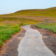 WALK INTO WELLNESS
Join State Parks for a guided, meditative walk around the Lake Oroville State Recreation Area that promotes health and wellness. Free walks focus on calming reflections and enlightening exercises while immersed in the beauty of nature. Sturdy shoes and a water bottle are recommended for participants. The last wellness walk is scheduled from 8 a.m. to 10 a.m. on Sunday, July 16 at Bidwell Canyon; meet at the Toll House Museum. CURRENT LAKE OPERATIONS Lake Oroville is at 894 feet elevation and storage is approximately 3.45 million acre-feet (MAF), which is 98 percent of its total capacity and 136 percent of the historical average. Feather River releases are at 5,000 cfs today to meet downstream Delta water quality and outflow. Flows through the City of Oroville were increased to 1,500 cfs and releases from the Thermalito Afterbay Outlet (Outlet) are at 3,500 cfs for a total of 5,000 cfs downstream of the Outlet. With increasing temperatures additional flow fluctuations may occur next week through the City of Oroville. DWR continues to assess releases to the Feather River daily. The public can track precipitation, snow, reservoir levels, and more at the California Data Exchange Center. The Lake Oroville gage station is identified as “ORO”. All data as of midnight 7/13/2023. 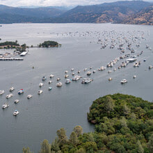 Lake Oroville Water Operations Winter storms and spring snowmelt filled the Lake Oroville reservoir to capacity, an increase of more than 2.5 million acre-feet of water since Dec. 1. The Department of Water Resources (DWR) continues releases from Lake Oroville through the Hyatt Powerplant and Thermalito Afterbay River Outlet. Total releases to the Feather River amount to 3,000 cubic feet per second (cfs), with adjustments being made to manage storage levels along with water quality and flows through the Sacramento-San Joaquin Delta. Over the past week, inflows into Lake Oroville have been in the range of 2,800 to 3,700 cfs and are projected to be in the same range for the coming week. DWR may intermittently use the main spillway this summer for water releases to manage storage within the Oroville complex or maintain Feather River temperature levels during ongoing river valve outlet system work near the Hyatt Powerplant. When the main spillway is not in use water may still be seen on the main spillway outlet as the seals on the eight radial gates are not designed to be watertight. The gate seals do not play a role in the structural integrity of the gates, which continue to operate as intended. DWR periodically maintains and adjusts the seals during low-reservoir conditions to improve their sealing capability. The radial gates were also last inspected and tested in Dec. 2022. Visitors to Oroville Dam may also notice minor amounts of water flowing from drains built into the emergency spillway. As the reservoir level has increased, water flow from the drains has increased, which is normal and expected with the emergency spillway design. The dam and emergency spillway continue to operate as intended. Driftwood and other floating debris on Lake Oroville are expected due to continued water inflows from tributaries and a high lake level, in combination with past wildfires impacting the watershed. Since January, DWR and California Department of Parks and Recreation (State Parks) staff have been collecting, containing, and pulling pieces of wood out of the lake and away from boat launch ramps using boom lines. However, boaters, water skiers, and other water recreationists should take precautions when operating boats on Lake Oroville and should remain alert for floating debris. The Lake Oroville reservoir is the largest storage facility in the State Water Project (SWP) and supports environmental and water delivery needs to 27 million Californians and reduces flood risks to downstream communities. DWR continues to closely monitor lake levels and will adjust releases accordingly to optimize operations for water storage and environmental protection while allowing for carryover storage into next year.  CAMPING AT LAKE OROVILLE The summer months invite everyone to get outside and enjoy the benefits of longer daylight hours. However, summer heat can make recreating outdoors tiring, which makes Lake Oroville the perfect place for your next camping adventure. The Lake Oroville State Recreation Area boasts 167 miles of shoreline and numerous tent, trailer or boat camping sites operated by State Parks. With the lake a short distance away, campers can cool off in the refreshing water one minute and grill some burgers on a barbecue the next. Lake Oroville is also home to floating campsites and boat-in campgrounds for those looking to spend more time on the water. Reserve a camping site at https://reservecalifornia.com or contact State Parks at (800) 444-7275. OROVILLE DAM CITIZENS ADVISORY COMMISSION The California Natural Resources Agency hosted a virtual Oroville Dam Citizens Advisory Commission meeting today via Zoom. In addition to public comment, presentations on dam safety projects and fiscal year 2023–24 Oroville Dam facility expenditures were provided. The Commission also continued conversations about inundation maps. The Citizens Advisory Commission is a forum for questions and feedback from the communities surrounding Oroville Dam. For information on the meeting, please visit https://bit.ly/OrovilleCAC. A transcript of the meeting will be available on the webpage in the coming weeks.  WALK INTO WELLNESS Join State Parks for a guided, meditative walk around the Lake Oroville State Recreation Area that promotes health and wellness. Free walks focus on calming reflections and enlightening exercises while immersed in the beauty of nature. Sturdy shoes and a water bottle are recommended for participants. The last wellness walk is scheduled from 8 a.m. to 10 a.m. on Sunday, July 16 at Bidwell Canyon; meet at the Toll House Museum. 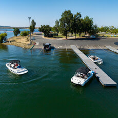 OROVILLE RECREATION
The Lake Oroville Visitor Center is open Monday through Friday between 9 a.m. and 5 p.m. The Visitor Center offers numerous educational exhibits, a theater featuring videos about the building of Oroville Dam, walking and hiking trails, and a 47-foot-tall observation tower providing unsurpassed panoramic views. DWR, State Parks, and the California Department of Fish and Wildlife maintain over 92 miles of trails in the Oroville area. An interactive map of recreation facilities, including open boat ramps, and their permitted uses (hike, bike, horse, multi) is available on DWR’s Lake Oroville Recreation webpage. A paper trail map is available at various locations, including most entrance kiosks and the Visitor Center. The marinas at Bidwell Canyon and Lime Saddle are open daily and provide a variety of services such as a shuttle and boat rentals. CURRENT LAKE OPERATIONS Lake Oroville is at 897 feet elevation and storage is approximately 3.49 million acre-feet (MAF), which is 99 percent of its total capacity and 133 percent of the historical average. Feather River releases were increased to 3,000 cfs today to meet downstream Delta water quality and outflow. Flows through the City of Oroville will be decreasing over the weekend. By Sunday, flows through the City of Oroville will be at 650 cfs and releases from the Thermalito Afterbay Outlet (Outlet) will be at 2,350 cfs for a total of 3,000 cfs downstream of the Outlet. With increasing temperatures additional flow fluctuations may occur next week through the City of Oroville. DWR continues to assess releases to the Feather River daily. The public can track precipitation, snow, reservoir levels, and more at the California Data Exchange Center. The Lake Oroville gage station is identified as “ORO”. All data as of midnight 7/6/2023. 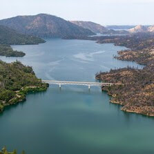 Lake Oroville Water Operations Winter storms and spring snowmelt have filled the Lake Oroville reservoir to capacity, an increase of more than 2.5 million acre-feet of water since Dec. 1. Although the Department of Water Resources (DWR) stopped releasing water on June 17 from the main spillway, water may still be seen on the main spillway outlet as the seals on the eight radial gates are not designed to be watertight. The gate seals do not play a role in the structural integrity of the gates, which continue to operate as intended. DWR periodically maintains and adjusts the seals during low-reservoir conditions to improve their sealing capability. The radial gates were also last inspected and tested in Dec. 2022. While water is not being released from the main spillway, water is being released from Lake Oroville through Hyatt Powerplant and the Thermalito Afterbay River Outlet. Water releases to the Feather River via these options are at 3,500 cfs, with adjustments being made as needed to ensure continued storage space in Lake Oroville for snowmelt runoff. Lake Oroville is full and at this level there is also the potential for some waves to splash over the crest of the emergency spillway if we experience any particularly windy days. While unlikely, DWR will be monitoring for the potential of any wave runup that might splash over the crest of the emergency spillway. Wave splash will not affect the integrity of the emergency spillway structure or Oroville Dam. Visitors to Oroville Dam may also notice minor amounts of water flowing from drains built into the emergency spillway. As the reservoir level has increased, water flow from the drains has increased, which is normal and expected with the emergency spillway design. The dam and emergency spillway continue to operate as intended. Driftwood and other floating debris on Lake Oroville are expected due to continued water inflows from tributaries and a high lake level, in combination with past wildfires impacting the watershed. Since January, DWR and California Department of Parks and Recreation (State Parks) staff have been collecting, containing, and pulling pieces of wood out of the lake and away from boat launch ramps using boom lines. However, boaters, water skiers, and other water recreationists should take precautions when operating boats on Lake Oroville and should remain alert for floating debris. The Lake Oroville reservoir is the largest storage facility in the State Water Project (SWP) and supports environmental and water delivery needs to 27 million Californians and reduces flood risks to downstream communities. DWR continues to closely monitor lake levels and will adjust releases accordingly to optimize operations for water storage and environmental protection while allowing for carryover storage into next year. 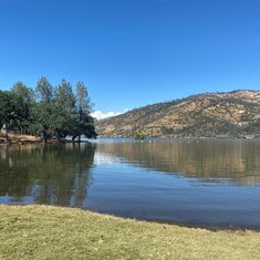 SWIM BEACHES The summer months have officially arrived and temperatures in Northern California will continue to climb beyond the moderate weather we’ve experienced so far. While Lake Oroville offers ample water opportunities for boating, kayaking or wakeboarding, the Lake Oroville State Recreation Area (LOSRA) and Oroville Wildlife Area (OWA) also offer several family-friendly swim beaches that are excellent locations to beat the heat. Swim beaches within the LOSRA and OWA provide shallow wading and swimming opportunities for visitors of all ages with nearby restroom facilities. Some locations also include picnic benches and barbecue facilities that are perfect for hosting a fun family gathering. Beat the heat this summer and relax at one of our recreation facility swim beaches – Loafer Creek at Lake Oroville, Monument Hill or Larkin Road at the Thermalito Afterbay, or the South or North Thermalito Forebay.  FOURTH OF JULY IN OROVILLE Celebrate our nation’s independence on July 4 with a spectacular fireworks show at the Oroville Airport located at 225 Chuck Yeager Way. Patriotic festivities begin Saturday, July 1 with a fly-in and car show at the airport from 8 a.m. to 3 p.m. The free event includes a pancake breakfast, food vendors, art and craft vendors, remote-controlled helicopter demonstrations, airplanes, classic cars, and low riders. On Tuesday, July 4, kick off the holiday with a meet and greet with Oroville’s first responders from 9 a.m. to 1 p.m. at the Oroville Airport. Later that evening, the Fourth of July fireworks show begins 30 minutes after sunset. The Oroville Chamber of Commerce’s website has several maps highlighting prime locations for fireworks viewing so you can plan ahead.  OROVILLE RECREATION
The Lake Oroville Visitor Center is open Monday through Friday between 9 a.m. and 5 p.m. The Visitor Center offers numerous educational exhibits, a theater featuring videos about the building of Oroville Dam, walking and hiking trails, and a 47-foot-tall observation tower providing unsurpassed panoramic views. DWR, State Parks, and the California Department of Fish and Wildlife maintain over 92 miles of trails in the Oroville area. Paved trails at the Lake Oroville Visitor Center, Spillway Day Use Area, and at the North Forebay Day Use Area offer accessible trails with only slight elevation changes. Other trails, such as the Potter's Ravine Trail near Oroville Dam, offer steep elevation changes to challenge hikers and mountain bikers. The Saddle Dam Trailhead has facilities for equestrians, including a large parking area to accommodate horse trailers, water troughs, and hitching posts, and easy access to trails designated for hikers and horses. An interactive map of recreation facilities, including open boat ramps, and their permitted uses (hike, bike, horse, multi) is available on DWR’s Lake Oroville Recreation webpage. A paper trail map is available at various locations, including most entrance kiosks and the Visitor Center. The marinas at Bidwell Canyon and Lime Saddle are open daily and provide a variety of services such as a shuttle and boat rentals. CURRENT LAKE OPERATIONS Lake Oroville is at 899 feet elevation and storage is approximately 3.53 million acre-feet (MAF), which is 100 percent of its total capacity and 130 percent of the historical average. The Feather River releases are at 3,500 cubic feet per second (cfs). Flows through the City of Oroville are 650 cfs with 2,850 cfs released from the Thermalito Afterbay Outlet (Outlet) for a total of 3,500 cfs downstream of the Outlet. DWR continues to assess releases to the Feather River daily. The public can track precipitation, snow, reservoir levels, and more at the California Data Exchange Center. The Lake Oroville gage station is identified as “ORO”. All data as of midnight 6/22/2023. 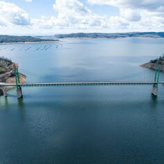 Lake Oroville Water Operations The Department of Water Resources (DWR) continues to make releases from Lake Oroville using the main spillway at Oroville Dam. Ongoing releases ensure continued storage space in Lake Oroville for spring runoff from snowmelt and are closely coordinated with the U.S. Army Corps of Engineers and downstream water operators. Total releases to the Feather River amount to 4,000 cubic feet per second (cfs) with 2,200 cfs being routed down the low-flow channel which flows through the City of Oroville. An additional 1,800 cfs is being released from the Thermalito Afterbay River Outlet, located 5 miles downstream from Oroville. Since Dec. 1, Lake Oroville’s storage has increased more than 230 feet and gained over 2.4 million acre-feet of water. Lake Oroville is currently at 98 percent capacity and is expected to reach full capacity this month. As Oroville reaches full capacity there will be the potential for some waves to splash over the crest of the emergency spillway if we experience any particularly windy days. While unlikely, DWR will be monitoring for the potential of any wave runup that might splash over the crest of the emergency spillway. Wave splash will not affect the integrity of the emergency spillway structure or Oroville Dam. Visitors to Oroville Dam may also notice minor amounts of water flowing from drains built into the emergency spillway. As the reservoir level has increased, water flow from the drains has increased, which is normal and expected with the emergency spillway design. The dam and emergency spillway continue to operate as intended. Driftwood and other floating debris on Lake Oroville are expected due to continued water inflows from tributaries and a high lake level, in combination with past wildfires impacting the watershed. Since January, State officials and marina partners have been collecting, containing, and pulling pieces of wood out of the lake and away from boat launch ramps using boom lines. However, boaters, water skiers, and other water recreationists should take precautions when operating boats on Lake Oroville and should remain alert for floating debris. The Lake Oroville reservoir is the largest storage facility in the State Water Project (SWP) and supports environmental and water delivery needs to 27 million Californians and reduces flood risks to downstream communities. DWR continues to closely monitor lake levels and will adjust releases accordingly to optimize operations for water storage and environmental protection while allowing for carryover storage into next year. 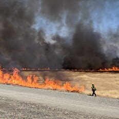 THERMALITO FOREBAY VEGETATION MANAGEMENT For the third straight year, DWR, CAL FIRE/Butte County Fire Department, and the California Department of Parks and Recreation (State Parks) will conduct a series of prescribed burns around the Thermalito Forebay. The targeted two-week window for this project is June 3 to June 17 and depends on favorable weather conditions. The Forebay Vegetation Management Project (VMP) was first conducted in 2021 to improve valley grassland and vernal pool habitat. Invasive annual grasses and other invasive species like the yellow star thistle degrade native grasslands and fire is a valuable tool to combat this degradation. Because invasive species have seeds and dry material called thatch that build up on the soil, it is important to burn the same area multiple years in a row. When completed during the right stage in these species' growth cycle, the control burns eradicate the current crop, reduce the dry residual thatch, and decreases the spread of seeds. The area has seen a significant decline in the volume of invasive grasses and star thistles since the project began. The project burns also allow DWR to continue post-fire studies on vernal pool habitat. CAL FIRE/Butte County Fire Department will also be conducting prescribed burns near the Rabe Road Shooting Range during this period. Smoke from the control burns will be highly visible in the Oroville area. 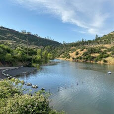 CAR-TOP BOAT LAUNCHES State Parks has closed the Nelson Bar Car-Top Boat Launch due to high lake water levels that have inundated the parking lot, which is at an elevation between 891 to 895 feet. The parking lot and car-top launch ramp will reopen again once Lake Oroville water levels recede. High water levels have also permitted the Vinton Gulch Car-Top Boat Launch to reopen. The car-top boat launch may be accessed via State Route 70 and Cherokee Road along the west branch of the north fork arm of Lake Oroville. WALK INTO WELLNESS Join State Parks for a series of guided, meditative walks around the Lake Oroville State Recreation Area that promote health and wellness. These free walks focus on calming reflections and enlightening exercises while immersed in the beauty of nature. Sturdy shoes and a water bottle are recommended for participants. Wellness walks are scheduled from 8 a.m. to 10 a.m. on the following dates and locations:
 OROVILLE RECREATION
The Lake Oroville Visitor Center is open Monday through Friday between 9 a.m. and 5 p.m. The Visitor Center offers numerous educational exhibits, a theater featuring videos about the building of Oroville Dam, and a 47-foot-tall observation tower providing unsurpassed panoramic views. DWR, State Parks, and CDFW maintain over 92 miles of trails in the Oroville area. An interactive map of recreation facilities, including open boat ramps, and their permitted uses is available on DWR’s Lake Oroville Recreation webpage. A paper trail map is available at various locations, including most entrance kiosks and the Visitor Center. The marinas at Bidwell Canyon and Lime Saddle are open daily and provide a variety of services such as a shuttle and boat rentals. CURRENT LAKE OPERATIONS Lake Oroville is at 895 feet elevation and storage is approximately 3.47 million acre-feet (MAF), which is 98 percent of its total capacity and 123 percent of the historical average. The Feather River releases are at 4,000 cubic feet per second (cfs). Flows through the City of Oroville are 2,200 cfs with 1,800 cfs released from the Thermalito Afterbay Outlet (Outlet) for a total of 4,000 cfs downstream of the Outlet. DWR continues to assess releases to the Feather River daily. The public can track precipitation, snow, reservoir levels, and more at the California Data Exchange Center. The Lake Oroville gage station is identified as “ORO”. All data as of midnight 6/2/2023. 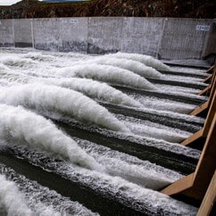 Lake Oroville Water Operations The Department of Water Resources (DWR) continues to make releases from Lake Oroville using the main spillway at Oroville Dam. Ongoing releases ensure continued storage space in Lake Oroville for spring runoff from snowmelt and are closely coordinated with the U.S. Army Corps of Engineers and downstream water operators. Total releases to the Feather River amount to 9,000 cubic feet per second (cfs) with 2,200 cfs being routed down the low-flow channel which flows through the City of Oroville. An additional 6,800 cfs is being released from the Thermalito Afterbay River Outlet, located 5 miles downstream from Oroville. DWR continues to closely monitor lake levels and will adjust releases accordingly to optimize operations for water storage and environmental protection while allowing for carryover storage into next year. Driftwood and other floating debris on Lake Oroville are expected due to continued water inflows from tributaries and a high lake level, in combination with past wildfires impacting the watershed. Since January, State officials and marina partners have been collecting, containing, and pulling pieces of wood out of the lake and away from boat launch ramps using boom lines. However, boaters, water skiers, and other water recreationists should take precautions when operating boats on Lake Oroville and should remain alert for floating debris. Since Dec. 1, Lake Oroville’s storage has increased approximately 230 feet and gained over 2.44 million acre-feet of water. Lake Oroville is currently at 96 percent capacity and is expected to reach full capacity in June. The Lake Oroville reservoir is the largest storage facility in the State Water Project (SWP) and supports environmental and water delivery needs to 27 million Californians and reduces flood risks to downstream communities. 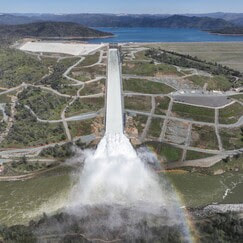 STATE WATER PROJECT ADAPTS TO CLIMATE CHANGE As California experiences more extreme swings between wet and dry periods, DWR continues to deploy innovative forecasting and water management strategies for the State Water Project (SWP) to adapt to California’s changing climate. The SWP delivers an average of 2.4 million acre-feet of water to more than 27 million Californians and 750,000 acres of farmland while providing multiple benefits, such as flood control, hydropower generation, fish and wildlife protections, drinking water quality, and recreational opportunities. Releases from Lake Oroville, the largest SWP reservoir, also keep salt water from intruding into the Delta and contaminating drinking water or water used to irrigate crops. The SWP diverts and stores surplus water during wet periods and distributes water to 29 water contractors – all public agencies that have contracts for water that is distributed to farms, homes, and industry. Annual water supply deliveries depend on rainfall runoff, snowpack, existing water in storage facilities, Delta pumping capacity, and environmental regulations. The State Water Project is required to follow more than one regulation when releasing water from SWP reservoirs, such as Lake Oroville. Releases from Lake Oroville meet requirements set forth by the State Water Resources Control Board, U.S. Army Corps of Engineers, California Department of Fish and Wildlife (CDFW), Federal Energy Regulatory Commission, and National Marine Fisheries Service. The SWP release decisions are also coordinated with the U.S. Bureau of Reclamation which operates the Central Valley Project, since many requirements must be jointly met by the two projects. DWR continues to explore several improvements to existing SWP infrastructure that can improve water supply reliability, water quality, water temperature control, and increased electricity integration of water supply infrastructure. Read more about DWR’s strategy for adapting to climate change. 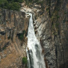 FEATHER FALLS A popular excursion at Lake Oroville during high-water level periods is to take a boat trip to the upper end of the Middle Fork Arm to view Feather Falls, a Yosemite-style waterfall of exquisite beauty. Along the way, there are many smaller waterfalls to see including some that tumble directly into Lake Oroville such as Bean Creek and Frey Creek. Bring a picnic lunch, a camera, and don’t forget your fishing pole. There are unlimited bass fishing opportunities along the route and trout fishing can also be good where the cold mountain streams enter the lake. 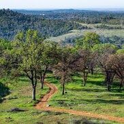 WALK INTO WELLNESS Join the California Department of Parks and Recreation (State Parks) for a series of guided, meditative walks around the Lake Oroville State Recreation Area that promote health and wellness. These free walks focus on calming reflections and enlightening exercises while immersed in the beauty of nature. Sturdy shoes and a water bottle are recommended for participants. Wellness walks are scheduled from 8 a.m. to 10 a.m. on the following dates and locations:
 OROVILLE RECREATION
The Lake Oroville Visitor Center is open Monday through Friday between 9 a.m. and 5 p.m. The Visitor Center offers numerous educational exhibits, a theater featuring videos about the building of Oroville Dam, and a 47-foot-tall observation tower providing unsurpassed panoramic views. DWR, State Parks, and CDFW maintain over 92 miles of trails in the Oroville area. An interactive map of recreation facilities, including open boat ramps, and their permitted uses is available on DWR’s Lake Oroville Recreation webpage. A paper trail map is available at various locations, including most entrance kiosks and the Visitor Center. The marinas at Bidwell Canyon and Lime Saddle are open daily and provide a variety of services such as a shuttle and boat rentals. CURRENT LAKE OPERATIONS Lake Oroville is at 891 feet elevation and storage is approximately 3.4 million acre-feet (MAF), which is 96 percent of its total capacity and 122 percent of the historical average. The Feather River releases are at 9,000 cubic feet per second (cfs). Flows through the City of Oroville are 2,200 cfs with 6,800 cfs released from the Thermalito Afterbay Outlet (Outlet) for a total of 9,000 cfs downstream of the Outlet. DWR continues to assess releases to the Feather River daily. The public can track precipitation, snow, reservoir levels, and more at the California Data Exchange Center. The Lake Oroville gage station is identified as “ORO”. All data as of midnight 5/25/2023. 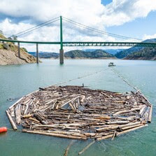 Lake Oroville Water Releases Continue The Department of Water Resources (DWR) continues to make releases from Lake Oroville using the main spillway at Oroville Dam. Ongoing releases ensure continued storage space in Lake Oroville for spring runoff from snowmelt and are closely coordinated with the U.S. Army Corps of Engineers and downstream water operators. Total releases to the Feather River amount to 13,000 cubic feet per second (cfs) with 5,650 cfs being routed down the low-flow channel which flows through the City of Oroville. An additional 7,350 cfs is being released from the Thermalito Afterbay River Outlet, located 5 miles downstream from Oroville. DWR continues to closely monitor lake levels and will adjust releases accordingly to optimize operations for water storage and environmental protection while allowing for carryover storage into next year. Driftwood and other floating debris at the state recreation area are expected due to continued water inflows from tributaries and a high lake level, in combination with past wildfires impacting the watershed. Since January, State officials and marina partners have been collecting, containing, and pulling pieces of wood out of the lake and away from boat launch ramps using boom lines. However, boaters, water skiers, and other water recreationists should take precautions when operating boats on Lake Oroville and should remain alert for floating debris. Since Dec. 1, Lake Oroville’s storage has increased approximately 230 feet and gained over 2.4 million acre-feet of water. Lake Oroville is currently at 96 percent capacity and is expected to reach full capacity this spring. The Lake Oroville reservoir is the largest storage facility in the State Water Project (SWP) and supports environmental and water delivery needs to 27 million Californians and reduces flood risks to downstream communities.  WALK INTO WELLNESS Join the California Department of Parks and Recreation (State Parks) for a series of guided, meditative walks around the Lake Oroville State Recreation Area that promote health and wellness. These free walks focus on calming reflections and enlightening exercises while immersed in the beauty of nature. Sturdy shoes and a water bottle are recommended for participants. Wellness walks are scheduled from 8 a.m. to 10 a.m. on the following dates and locations:
 HOURS EXTENDED FOR SPILLWAY DAY-USE AREA As the summer months approach and daylight hours linger, the Spillway Boat Ramp and Day Use Area is now open from 5 a.m. to 11 p.m. All vehicles and trailers are subject to inspection by the California Highway Patrol (CHP) for security purposes. There are five other boat ramps at Lake Oroville that are open 24 hours a day and do not entail CHP inspections: Bidwell Canyon, Loafer Point, Loafer Creek, Lime Saddle and Enterprise.  WATER SAFETY MONTH The State Water Project’s (SWP) reservoirs located throughout California will welcome the upcoming summer months with high water levels. Heavy storms this past winter will also bring fast flows and cold temperatures to rivers and streams as mountain snow melts. When recreating at SWP facilities, you should always keep water safety a top priority and stay alert for cold, fast, and fluctuating water conditions. As part of Water Safety Month, keep these water safety tips in mind to have a fun and safe summer:
 OROVILLE RECREATION
DWR, State Parks, and CDFW maintain over 92 miles of trails in the Oroville area. Paved trails at the Lake Oroville Visitor Center, Spillway Day Use Area, and at the North Forebay Day Use Area offer accessible trails with only slight elevation changes. Other trails, such as the Brad Freeman Trail near Oroville Dam, offer steep elevation changes to challenge hikers and mountain bikers. The Saddle Dam Trailhead has facilities for equestrians including a large parking area to accommodate horse trailers, water troughs, and hitching posts, and easy access to trails designated for hikers and horses. An interactive map of recreation facilities, including open boat ramps, and their permitted uses is available on DWR’s Lake Oroville Recreation webpage. A paper trail map is available at various locations, including most entrance kiosks and the Visitor Center. The marinas at Bidwell Canyon and Lime Saddle are open daily and provide a variety of services such as a shuttle and boat rentals. The Lake Oroville Visitor Center is open Monday through Friday between 9 a.m. and 5 p.m. The Visitor Center offers numerous educational exhibits, a theater featuring videos about the building of Oroville Dam, and a 47-foot-tall observation tower providing unsurpassed panoramic views. CURRENT LAKE OPERATIONS Lake Oroville is at 890 feet elevation and storage is approximately 3.38 million acre-feet (MAF), which is 96 percent of its total capacity and 122 percent of the historical average. The Feather River releases are at 13,000 cubic feet per second (cfs). Flows through the City of Oroville are 5,650 cfs with 7,350 cfs released from the Thermalito Afterbay Outlet (Outlet) for a total of 13,000 cfs downstream of the Outlet. DWR continues to assess releases to the Feather River daily. The public can track precipitation, snow, reservoir levels, and more at the California Data Exchange Center. The Lake Oroville gage station is identified as “ORO”. All data as of midnight 5/18/2023. |
Archives
October 2023
Categories
All
|

 RSS Feed