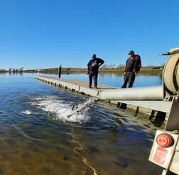
 February 25, 2022 Feather River Hatchery Steelhead Planting The Feather River Fish Hatchery has raised over 630,700 steelhead for release this year. The steelhead were raised for a full year at the hatchery and averaged about 8 to 9 inches in length. Around 129,300 steelhead were released in the Thermalito Afterbay – plantings occurred in December 2021 and February 2022. This is a significant increase from normal planting years and will contribute to a more productive recreational fishery. The remaining approximately 501,400 steelhead were released into the Feather River at Boyd’s Pump Boat Launch Feb. 3 to Feb. 18 to meet mitigation requirements. Releasing these young fish further downstream improves their chance of survival. This shortened migration route allows juvenile fish to avoid predators. Steelhead are a salmonid species and are an ocean-going trout. They will migrate from freshwater to marine (ocean), returning to freshwater environments to spawn. They can spawn several times during their lifetime and can live up to eight years. Their “steelhead” name comes from their appearance, a more streamlined shape than Chinook salmon and with a silvery or brassy color as an adult. The Feather River Fish Hatchery is a California State Water Project (SWP) facility built in the late 1960s to mitigate impacts on fish migration resulting from the construction of Oroville Dam which prevented access to spawning grounds further upstream. The Department of Water Resources (DWR) maintains the facility and funds the hatchery operations, fish spawning, rearing, and stocking activities provided by California Department of Fish and Wildlife staff.  DWR SURVEY OF LAKE OROVILLE DWR is conducting a bathymetric (underwater) survey of Lake Oroville to complete a comprehensive topography, or map, of the lakebed. The underwater survey will complement a December 2021 survey that took advantage of the lake’s low water elevations to perform an ‘above water level’ survey of Lake Oroville’s topography, dams, and related structures. Using highly accurate LiDAR remote sensing, the December survey produced precise, three-dimensional information of Lake Oroville’s lakebed. Similar data will be collected from the bathymetric survey. Data from both surveys will provide DWR with up-to-date information that can be used to determine changes in sedimentation, update the reservoir’s storage-stage relationships, and inform future boat ramp extensions. 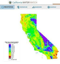 DWR LAUNCHES CALIFORNIA WATER WATCH The Department of Water Resources (DWR) has a new website to better inform Californians about hydrologic conditions, forecasts, and information at the scale of their local watershed. The website, California Water Watch, allows the public to obtain a quick snapshot of local and statewide water conditions and was developed as part of the Governor’s drought emergency proclamation. Information is updated from a variety of data sources and will assist the public to research, learn, and stay informed about California’s most precious resource – water. The website displays current statewide hydroclimate and water supply conditions, including precipitation, temperature, reservoir storage, groundwater conditions, snowpack, streamflow, soil moisture and vegetation conditions. Links to information about drought conditions and how water is used in California are also provided. 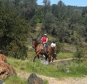 OROVILLE RECREATION
The Loafer Point, Bidwell Canyon, and Lime Saddle boat ramps are open. The Oroville Dam Spillway boat ramp remains closed for repairs. The Foreman Creek and Stringtown cartop boat ramps are also open. Intermittent, short duration closures of the Oroville Dam Crest parking lot may occur to accommodate Lakeside Access Road construction activities. The popular walking/bicycling trail across the top of the dam will remain open and parking will continue to be available at the Upper Overlook. Information on current boat ramp status can be found on the California State Parks’ Lake Oroville State Recreation Area webpage. Scroll down to the link for “Current Launch Ramp Status”. The Lake Oroville Visitor Center is open to the public on Tuesdays, Wednesdays, and Thursdays from 9 a.m. to 5 p.m. Pick up the Lake Oroville Trails Map, which shows more than 97 miles of trails available to equestrians, bicyclists, and hikers, at Lake Oroville State Recreation Area (LOSRA) kiosks, the Oroville Area Chamber of Commerce, and Feather River Recreation and Parks District. The Loafer Creek Recreation Area continues to be closed due to waterline repair (boat ramp and trail access allowed). Visit the California Parks LOSRA webpage for current information on facility status and campground reservations. An interactive map of recreation facilities in DWR’s Oroville-Thermalito Complex is available on DWR’s Lake Oroville Recreation webpage. Information about the 11,000-acre Oroville Wildlife Area is available on the California Department of Fish and Wildlife webpage. CURRENT LAKE OPERATIONS The elevation of Oroville’s reservoir is about 748 feet elevation and storage is about 1.66 million acre-feet, which is 47 percent of its total capacity and 76 percent of historical average. Temperatures over the weekend are forecasted to be in the low 60s to low 40s. Next week’s temperatures are forecasted to range between upper 60’s and low-70s to low or upper-40s at night. A chance of rain is forecasted in the Feather River watershed next week. The average daily inflows this week have been around 4,000 cubic feet per second (cfs). Inflows through the weekend and next week are forecasted to be around 3,500 cfs to 4,000 cfs. Inflows are subject to change based upon on actual weather conditions. Total flows to the Feather River are 4,750 cfs. This increase is for downstream water quality and flow requirements. Flow in the low-flow channel through the City of Oroville is 650 cfs and flow through the Thermalito Afterbay Outlet is 4,100 cfs. Releases are assessed daily. The public can track precipitation, snow, reservoir levels, and more at the California Data Exchange Center at www.cdec.water.ca.gov. The Lake Oroville gage station is identified as “ORO”. All data as of midnight 2/24/2022 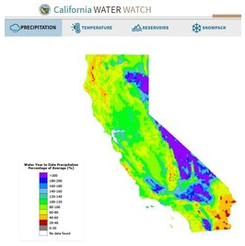 February 18, 2022 DWR Launches California Water Watch The Department of Water Resources (DWR) has a new website to better inform Californians about hydrologic conditions, forecasts, and information at the scale of their local watershed. The website, California Water Watch -- allows the public to obtain a quick snapshot of local and statewide water conditions and was developed as part of the Governor’s drought emergency proclamation. Information is updated from a variety of data sources and will assist the public to research, learn, and stay informed about California’s most precious resource – water. The website displays current statewide hydroclimate and water supply conditions, including precipitation, temperature, reservoir storage, groundwater conditions, snowpack, streamflow, soil moisture and vegetation conditions. Links to information about drought conditions and how water is used in California are also provided. 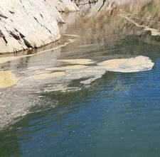 OROVILLE RECREATION
The Loafer Point, Bidwell Canyon, and Lime Saddle boat ramps are open. The Oroville Dam Spillway boat ramp remains closed for repairs. The Foreman Creek and Stringtown cartop boat ramps are also open. Information on current boat ramp status can be found on the California State Parks’ Lake Oroville State Recreation Area webpage. Scroll down to the link for “Current Boat Ramp Status”. The Lake Oroville Visitor Center is open to the public on Tuesdays, Wednesdays, and Thursdays from 9 a.m. to 5 p.m. Pick up the Lake Oroville Trails Map, which shows more than 97 miles of trails available to equestrians, bicyclists, and hikers, at Lake Oroville State Recreation Area (LOSRA) kiosks, the Oroville Area Chamber of Commerce, and Feather River Recreation and Parks District. The Loafer Creek Recreation Area continues to be closed due to waterline repair (boat ramp and trail access allowed). Visit the California Parks LOSRA webpage for current information on facility status and campground reservations. An interactive map of recreation facilities in DWR’s Oroville-Thermalito Complex is available on DWR’s Lake Oroville Recreation webpage. Information about the 11,000-acre Oroville Wildlife Area is available on the California Department of Fish and Wildlife webpage. LAKESIDE ACCESS ROAD Construction activities associated with the Lakeside Access Road project continue to result in intermittent closures of the Oroville Dam Crest parking lot on the northwest side of the dam as well as the Spillway Boat Ramp area. These short duration closures are anticipated to continue until the end of February. The popular walking/bicycling trail across the top of the dam will remain open and parking will continue to be available at the Upper Overlook. This project will consist of a new, permanent, paved road from the west side of Oroville Dam to the Spillway Boat Ramp parking lot on the “lakeside,” or waterside, of the Oroville Dam spillways. This new road will allow a more direct route when water levels are low in Lake Oroville. The new road will include two concrete traffic lanes, wide shoulders for walking and biking, guardrails, and safety signage. CURRENT LAKE OPERATIONS The elevation of Oroville’s reservoir is about 745 feet elevation and storage is about 1.63 million acre-feet, which is 46 percent of its total capacity and 77 percent of historical average. Dry and warm conditions are forecasted for this weekend with temperatures in the mid-70s. There’s slight chance of rain on Monday with warm and dry weather returning next week. The average daily inflows this week have been in the range of 2,000 cubic feet per second (cfs) to 3,000 cfs. Inflows through the weekend and next week are forecasted to be around 3,000 to 4,000 cfs. Inflows are subject to change based upon on actual weather conditions. Total flows to the Feather River are 3,500 cfs. This increase is for downstream water quality and flow requirements. Flow in the low-flow channel through the City of Oroville is 650 cfs and flow through the Thermalito Afterbay Outlet is 1,850 cfs. Releases are assessed daily. The public can track precipitation, snow, reservoir levels, and more at the California Data Exchange Center at www.cdec.water.ca.gov. The Lake Oroville gage station is identified as “ORO”. All data as of midnight 2/10/2022 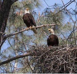 February 11, 2022 Five Year Anniversary February 2017 was a challenging time for Oroville residents and the surrounding communities. Over the past five years, the dam safety industry has been transformed statewide and nationally, leading to changes in how dams and related facilities are operated, inspected, and maintained. Public safety and flood protection remain the Department of Water Resources’ (DWR) top priorities in operational decisions regarding the Oroville reservoir. The reconstruction of the Oroville Dam’s main and emergency spillways using a more robust and modern design ensures that the Oroville Dam will continue to be able to provide flood protection to downstream communities. The Oroville Dam Comprehensive Needs Assessment (2020) identified priorities and appropriate solutions to bolster the integrity and resiliency of the Oroville Dam Complex; projects completed or underway include a seismic retrofit study, assessment of the FCO gate structure, installation of piezometers at Oroville Dam to collect data on seepage, and studies of area geology. Transparency, public engagement, and open communication also remain priorities as DWR works to restore trust and build relationships. Although the COVID-19 pandemic has restricted personal outreach and in-person community presentations, DWR continues to share information virtually regarding annual milestones, weather forecasts and operational updates, and engage community members in dialogue about needs and concerns. Residents are encouraged to participate in the Oroville Dam Citizens Advisory Commission that meets every three months. DWR is thankful to all the impacted residents for their patience and partnership as we move forward to achieve our shared goals of public safety, a reliable water supply for the state, environmental protections, and recreation opportunities for residents and visitors. Law Enforcement Training The Butte County Sheriff’s Office held an emergency response training at the Ronald B. Robie Thermalito Pumping-Generating Powerplant today (Feb. 11) which involved law enforcement and public safety personnel and equipment. The Sheriff’s Office advised the public this was a training exercise to provide participants with “real-time” response and rescue experiences to learn and refresh skills related to emergency preparedness and response. The Thermalito Powerplant remains fully operational.  CHRISTMAS TREE FISH HABITAT DWR, the California Conservation Corps (CCC), and the California Department of Fish and Wildlife (CDFW) completed constructing fish habitat structures at Lake Oroville and the Thermalito Afterbay using over 1,240 recycled Christmas trees. The trees were again collected by Chico Boy Scout Troop 2 and delivered free of charge to DWR by Recology, a local waste management company. To create the habitat on Lake Oroville and the Thermalito Afterbay, members of the CCC team bundle the recycled holiday trees together and anchor them in various locations around the lakebed. At Lake Oroville near the Loafer Creek Recreation Area, 916 trees were assembled into 64 structures. At the Thermalito Afterbay, 324 trees were assembled into 32 structures. Anchoring the trees allows them to remain submerged, providing juvenile fish safe refuge, and improving fisheries and recreational fishing opportunities. For nearly 30 years, DWR has worked with local groups to construct fish habitat structures, which is one of the longest continuously running fish habitat improvement programs in the State of California. The 2022 project is anticipated to be completed by Feb. 9. LAKESIDE ACCESS ROAD Construction activities associated with the Lakeside Access Road project continue to result in intermittent closures of the Oroville Dam Crest parking lot on the northwest side of the dam as well as the Spillway Boat Ramp area. These short duration closures are anticipated to continue until the end of February. The popular walking/bicycling trail across the top of the dam will remain open and parking will continue to be available at the Upper Overlook. This project will consist of a new, permanent, paved road from the west side of Oroville Dam to the Spillway Boat Ramp parking lot on the “lakeside,” or waterside, of the Oroville Dam spillways. This new road will allow a more direct route when water levels are low in Lake Oroville. The new road will include two concrete traffic lanes, wide shoulders for walking and biking, guardrails, and safety signage. 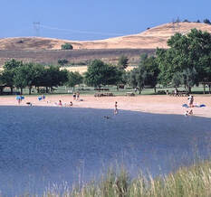 OROVILLE RECREATION
The Loafer Point, Bidwell Canyon, and Lime Saddle boat ramps are open. The Oroville Dam Spillway boat ramp remains closed for repairs. The Foreman Creek and Stringtown cartop boat ramps are also open. Information on current boat ramp status can be found on the California State Parks’ Lake Oroville State Recreation Area webpage. Scroll down to the link for “Current Boat Ramp Status”. The Lake Oroville Visitor Center is open to the public on Tuesdays, Wednesdays, and Thursdays from 9 a.m. to 5 p.m. Pick up the Lake Oroville Trails Map, which shows more than 97 miles of trails available to equestrians, bicyclists, and hikers, at Lake Oroville State Recreation Area (LOSRA) kiosks, the Oroville Area Chamber of Commerce, and Feather River Recreation and Parks District. The Loafer Creek Recreation Area continues to be closed due to waterline repair (boat ramp and trail access allowed). Visit the California Parks LOSRA webpage for current information on facility status and campground reservations. An interactive map of recreation facilities in DWR’s Oroville-Thermalito Complex is available on DWR’s Lake Oroville Recreation webpage. Information about the 11,000-acre Oroville Wildlife Area is available on the California Department of Fish and Wildlife webpage. CURRENT LAKE OPERATIONS The elevation of Oroville’s reservoir is about 745 feet elevation and storage is about 1.63 million acre-feet, which is 46 percent of its total capacity and 77 percent of historical average. Dry and warm conditions are forecasted for this weekend with temperatures in the mid-70s. There’s slight chance of rain on Monday with warm and dry weather returning next week. The average daily inflows this week have been in the range of 2,000 cubic feet per second (cfs) to 3,000 cfs. Inflows through the weekend and next week are forecasted to be around 3,000 to 4,000 cfs. Inflows are subject to change based upon on actual weather conditions. Total flows to the Feather River are 3,500 cfs. This increase is for downstream water quality and flow requirements. Flow in the low-flow channel through the City of Oroville is 650 cfs and flow through the Thermalito Afterbay Outlet is 1,850 cfs. Releases are assessed daily. The public can track precipitation, snow, reservoir levels, and more at the California Data Exchange Center at www.cdec.water.ca.gov. The Lake Oroville gage station is identified as “ORO”. All data as of midnight 2/10/2022 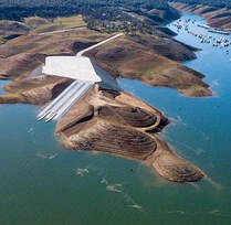 January 28, 2022 Oroville Recreation Advisory Committee The Oroville Recreation Advisory Committee will hold a public virtual meeting on Friday, Feb. 4 at 9 a.m. Interested persons can join the meeting on Zoom at https://ca-water-gov.zoom.us/j/86898170840?pwd=VmRadjZsQmQrVGpJWk1jayt1UHI5Zz09 or visit the DWR Events webpage. ORAC was established by the Federal Energy Regulatory Commission (FERC) to review and provide recommendations regarding DWR’s recreation plan for the Project-2100 – Oroville Facilities. The 13-member committee is made up of representatives from state and local government, sports and recreation groups, and business and community organizations. Loafer Point Boat Ramp The Loafer Point Stage II boat ramp has reopened for boat launching. The first construction phase of the new boat ramp was completed in May 2021, adding six boat launch lanes to 707 feet, 180 trailered parking spaces, and offering immediate access to the open waters of Lake Oroville. Falling lake levels due to drought conditions forced its closure a month later in June 2021. Taking advantage of historic low lake elevations, construction to extend three of the six boat launch lanes further into the lakebed to improve low-water access to Lake Oroville began the first week of October and succeeded in constructing lanes to 675 feet before rising lake elevations prevented further work. With lake elevations currently at 744 feet, all six lanes of the Stage II boat ramp are currently available. The Loafer Point Stage I boat ramp was completed in 2020 and added three new boat launch lanes from a full lake down to 805 feet, a new parking area, and a restroom facility. Both boat ramps are adjacent to the Loafer Creek Recreation Day Use Area and Campground, rounding out a full-service recreation destination with nearby trails, campgrounds, boating, and marina. Excepting the Loafer Point Stage II boat ramp and the trails network, the remainder of the Loafer Creek Recreation Area is currently closed due to waterline repair. Trails within the Loafer Creek Recreation Area can be accessed from the Bidwell Saddle Dam Trailhead located on Kelly Ridge Road. Photo: Loafer Point Stage II boat ramp with six lanes for boat launching 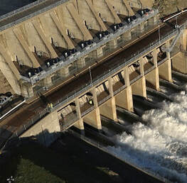 DWR Issues Revised Water Allocation Due to the series of storms in December 2021, the Department of Water Resources (DWR) has increased the State Water Project (SWP) allocation to 15 percent of requested supplies for 2022, an increase over the December allocation that covered only critical health and safety needs of the 29 water agencies that contract to receive State Water Project supplies. While drought conditions still persist, December’s precipitation enabled DWR to convey and store water in San Luis Reservoir, allowing for the modest increase in water deliveries. DWR continues to plan for a third dry year by preserving storage in Lake Oroville, the State Water Project’s largest reservoir. Water releases from Lake Oroville will be prioritized to maintain Delta water quality, protect endangered species, and meet senior water right needs. Each year, DWR makes an initial SWP allocation on Dec. 1. Allocations are updated as snowpack and runoff information are assessed, with a final allocation typically determined in May or June. Read the full news release on the DWR News webpage. Photo: Dinosaur Point boat launch on San Luis Reservoir (Aug. 2021) Lakeside Access Road Construction activities associated with the Lakeside Access Road project continue to result in intermittent closures of the Oroville Dam Crest parking lot on the northwest side of the dam as well as the Spillway Boat Ramp area. These short duration closures are anticipated to continue until the end of February. The popular walking/bicycling trail across the top of the dam will remain open and parking will continue to be available at the Upper Overlook. This project will consist of a new, permanent, paved road from the west side of Oroville Dam to the Spillway Boat Ramp parking lot on the “lakeside,” or waterside, of the Oroville Dam spillways. This new road will allow a more direct route when water levels are low in Lake Oroville. The new road will include two concrete traffic lanes, wide shoulders for walking and biking, guardrails, and safety signage.  Oroville Recreation
The Loafer Point Stage II, Bidwell Canyon Stage II, and Lime Saddle Boat Ramps are open. The Spillway boat ramp remains closed for repair. The Foreman Creek and Stringtown cartop boat ramps have also reopened. Information on current boat ramp status can be found on the State Park’s Lake Oroville State Recreation Area webpage. Scroll down to the link for “Current Boat Ramp Status”. The Lake Oroville Visitor Center is open to the public on Tuesdays, Wednesdays, and Thursdays from 9 a.m. to 5 p.m. Pick up the Lake Oroville Trails Map, which shows more than 97 miles of trails available to equestrians, bicyclists, and hikers, at Lake Oroville State Recreation Area (LOSRA) kiosks, the Oroville Area Chamber of Commerce, and Feather River Recreation and Parks District. The Loafer Creek Recreation Area continues to be closed due to waterline repair (boat ramp and trail access allowed). Visit the California Parks LOSRA webpage for current information on facility status and campground reservations. An interactive map of recreation facilities in DWR’s Oroville-Thermalito Complex is available on DWR’s Lake Oroville Recreation webpage. Information about the 11,000-acre Oroville Wildlife Area is available on the California Department of Fish and Wildlife webpage. Photo: Horseback riding near Saddle Dam Trailhead Current Lake Operations The elevation of Oroville’s reservoir is about 744 feet elevation and storage is about 1.62 million acre-feet, which is 46 percent of its total capacity and 80 percent of historical average. The forecast is for highs in the low- to mid-60s and lows in the low 40s coupled with dry conditions this weekend and into next week. The average daily inflows this week have been in the range of 3,000 cubic feet per second (cfs) to 4,000 cfs. Inflows through the weekend and next week are forecasted to be in the range of 2,000 to 3,500 cfs. Inflows are subject to change based upon on actual weather conditions. Total flows to the Feather River were increased on Friday and Saturday to 3,000 cfs. This increase is for downstream water quality and flow requirements. By Saturday, flow in the low-flow channel through the City of Oroville will be 650 cfs and flow through the Thermalito Afterbay Outlet will be 2,350 cfs. Releases are assessed daily. The public can track precipitation, snow, reservoir levels, and more at the California Data Exchange Center at www.cdec.water.ca.gov. The Lake Oroville gage station is identified as “ORO”. All data as of midnight 1/27/2022 ### Know someone who would like to receive Community Updates? They can email their request to oroville@water.ca.gov. 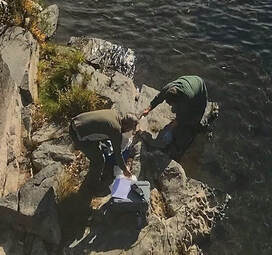 January 21, 2022 DWR Issues Revised Water Allocation Due to the series of storms in December 2021, the Department of Water Resources (DWR) is increasing the State Water Project (SWP) allocation to 15 percent of requested supplies for 2022, an increase over the December allocation that covered only critical health and safety needs of the 29 water agencies that contract to receive State Water Project supplies. While drought conditions still persist, December’s precipitation enabled DWR to convey and store water in San Luis Reservoir, allowing for the modest increase in water deliveries. DWR continues to plan for a third dry year by preserving storage in Lake Oroville, the State Water Project’s largest reservoir. Water releases from Lake Oroville will be prioritized to maintain Delta water quality, protect endangered species, and meet senior water right needs. Each year, DWR makes an initial SWP allocation on Dec. 1. Allocations are updated as snowpack and runoff information are assessed, with a final allocation typically determined in May or June. Read the full news release on the DWR News webpage. Photo: Dinosaur Point boat launch on San Luis Reservoir (Aug. 2021) Drought Update January’s dry weather reflects California’s weather variability -- not only from year to year but within the water year as well (Oct. 1 to Sept. 30). California has received more precipitation this water year as compared to this time last year but the abrupt change from December’s series of strong storms to a very dry January is a kind of “weather whiplash” that is becoming more common as climate change impacts continue to grow. The remainder of the wet season is still ahead. California receives 75 percent of its precipitation from November through March, half of which is typically received between December through February. Currently the statewide snowpack is around 58 percent of seasonal average and about 113 percent of average for this date. California needs above average precipitation throughout the winter to offset record-setting drought conditions and replenish reservoirs. Currently, Lake Oroville is only filled to 44 percent of its capacity and major reservoirs across the state are at an average of 42 percent capacity. Governor Newsom has called on Californians to voluntarily reduce their water use by 15 percent with simple measures to protect water reserves. The October 2021 emergency proclamation expanded the drought emergency statewide and authorized the State Water Board to ban wasteful water uses, boosting conservation efforts. Learn how to save for the future by visiting the Save Our Water website.  Mid-Winter Bald Eagle Survey Environmental scientists from DWR participated in the National Midwinter Bald Eagle Survey on Jan. 7. This nation-wide effort, coordinated by the U.S. Army Corps of Engineers, aims to determine bald eagle distribution and identify areas of important winter habitats. Because of bad weather on the day of the national survey, this year’s official count at Lake Oroville was only 20 bald eagles; however, an informal survey two days later counted well over 100 migrating eagles at the lake. Lake Oroville, the Feather River, and local area rice fields provide an ideal habitat for bald eagles. Fish are one of the eagle’s main food sources and water bodies like Lake Oroville, rivers, and rice fields provide a wide variety of fish and other favorite food sources such as waterfowl, small birds, and mammals. The many trees and snags (tall dead trees) near water areas provide prime roosting and hunting locations for the bald eagles that migrate to and through the area during the winter months as well as nesting opportunities for Lake Oroville’s resident “nesting pairs” who have established their home here. Protecting the area’s year-round bald eagle population living in the DWR Oroville-Thermalito Complex jurisdiction is the responsibility of DWR environmental scientists. The bald eagle is a protected species under the Migratory Bird Treaty Act of 1918 and Bald and Golden Eagle Protection Act of 1940. They were listed as an endangered species in 1978. Those protections have been successful, and the species is now federally delisted. DWR’s scientists monitor for and, if necessary, act against threats such as public intrusions, habitat loss, or other impacts to the eagles’ nesting areas. Photo: Bald eagle on top of pine tree at Lake Oroville Lakeside Access Road Construction activities associated with the Lakeside Access Road project continue to result in intermittent closures of the Oroville Dam Crest parking lot on the northwest side of the dam. These short duration closures are anticipated to continue until the end of January. The popular walking/bicycling trail across the top of the dam will remain open and parking will continue to be available at the Upper Overlook. This project will consist of a new, permanent, paved road from the west side of Oroville Dam to the Spillway Boat Ramp parking lot on the “lakeside,” or waterside, of the Oroville Dam spillways. This new road will allow a more direct route when water levels are low in Lake Oroville. The new road will include two concrete traffic lanes, wide shoulders for walking and biking, guardrails, and safety signage. Loafer Creek Recreation Area The Loafer Creek Recreation Area at Lake Oroville continues to be temporarily closed due to damages and interruption of the park’s main water supply system. Hikers, bicyclists, and equestrians can still access area trails from the Saddle Dam trailhead facility off Kelly Ridge Road. Trail users are advised to be aware of California Department of Parks and Recreation (State Parks) work trucks and utility vehicles in the area.  Oroville Recreation
Bidwell Canyon’s Stage II concrete boat ramp and the Lime Saddle Boat Ramp are open. The Spillway boat ramp remains closed for repair and the Loafer Point boat ramp is inaccessible due to continued closure of the Loafer Creek Recreation Area for waterline repairs. The Foreman Creek and Stringtown cartop boat ramps have also reopened. Information on current boat ramp status can be found on the State Park’s Lake Oroville State Recreation Area webpage. Scroll down to the link for “Current Boat Ramp Status”. The Lake Oroville Visitor Center is open to the public on Tuesdays, Wednesdays, and Thursdays from 9 a.m. to 5 p.m. Pick up the Lake Oroville Trails Map, which shows more than 97 miles of trails available to equestrians, bicyclists, and hikers, at Lake Oroville State Recreation Area (LOSRA) kiosks, the Oroville Area Chamber of Commerce, and Feather River Recreation and Parks District. Visit the California Parks LOSRA webpage for current information on facility status and campground reservations. An interactive map of recreation facilities in DWR’s Oroville-Thermalito Complex is available on DWR’s Lake Oroville Recreation webpage. Information about the 11,000-acre Oroville Wildlife Area is available on the California Department of Fish and Wildlife webpage. Photo: Observation Tower at Lake Oroville Visitor Center Current Lake Operations The elevation of Oroville’s reservoir is about 739 feet elevation and storage is about 1.58 million acre-feet, which is 45 percent of its total capacity and 80 percent of historical average. Dry and cool conditions are forecasted over the weekend and continuing into next week. The average daily inflows this week have been in the range of 4,000 cubic feet per second (cfs) to 5,000 cfs. Inflows through the weekend and next week are forecasted to be in the range of 3,000 cfs to 5,000 cfs. Inflows are subject to change based upon on actual weather conditions. Total flows to the Feather River are at 950 cfs for meeting downstream water quality and flow requirements. Flow in the low-flow channel, through the City of Oroville, is 650 cfs and flow through the Thermalito Afterbay Outlet is 300 cfs. Releases are assessed daily. The public can track precipitation, snow, reservoir levels, and more at the California Data Exchange Center at www.cdec.water.ca.gov. The Lake Oroville gage station is identified as “ORO”. All data as of midnight 1/20/2022 ### Know someone who would like to receive Community Updates? They can email their request to oroville@water.ca.gov.  January 14, 2022 Mid-Winter Bald Eagle Survey Environmental scientists from the Department of Water Resources (DWR) recently participated in the National Midwinter Bald Eagle Survey on Jan. 7. This nation-wide effort, coordinated by the U.S. Army Corps of Engineers, aims to determine bald eagle distribution and identify areas of important winter habitats. Because of bad weather on the day of the national survey, this year’s official count was only 20 bald eagles; however, an informal survey two days later counted well over 100 migrating eagles. Lake Oroville and the Feather River area provide an ideal habitat for bald eagles. Fish are one of the eagle’s main food sources and large water bodies like Lake Oroville provide a wide variety of fish and other favorite food sources such as waterfowl, small birds, and mammals. The many trees and snags (tall dead trees) near water areas provide prime roosting and hunting locations for the bald eagles that migrate to and through the area during the winter months as well as nesting opportunities for Lake Oroville’s resident “nesting pairs” who have established their home here. Protecting the area’s year-round bald eagle population living in the DWR Oroville-Thermalito Complex jurisdiction is the responsibility of the Oroville Field Division’s environmental scientists. The bald eagle is a protected species under the Migratory Bird Treaty Act of 1918 and Bald and Golden Eagle Protection Act of 1940. They were listed as an endangered species in 1978. Those protections have been successful, and the species is now federally delisted. DWR’s scientists monitor for and, if necessary, act against threats such as public intrusions, habitat loss, or other impacts to the eagles’ nesting areas. Photo: Bald eagle on top of pine tree at Lake Oroville  Hyatt Powerplant Returns to Service Oroville Dam’s Hyatt Powerplant returned to service on Jan. 1, 2022 after going offline on Aug. 5, 2021 due to historic low lake levels driven by the state’s ongoing severe drought conditions. An unexpectedly strong atmospheric river storm in late October, followed by a series of powerful December storms, has increased reservoir elevation levels from 630 feet on Oct. 21 to 733 on Jan. 14 – a gain of over 100 feet. Water levels are now well above the powerplant’s intakes, providing the necessary water pressure for efficient operation of the plant. Currently, Hyatt powerplant is utilizing one generating unit to produce electricity and supply it to the state’s electrical grid managed by the California Independent System Operator. Hyatt generation will initially remain low due to low agricultural demands and improved delta salinity conditions. DWR anticipates an average outflow of about 900 cubic feet per second, which will generate approximately 30 megawatts of power. As lake levels rise and demands increase, additional units will be brought back online. DWR completed major maintenance activities while the powerplant was offline to ensure the plant maintains its reliability and is available for water deliveries and power generation. DWR continues to manage Lake Oroville to balance storage needs with requirements for Delta outflows, water quality, and public health and safety requirements in an effort to conserve as much storage as possible in the event of another dry year. Read the news release at DWR News Releases. Photo: Hyatt Powerplant at Oroville Dam (showing four of the six generating units)  25th Anniversary of 1997 Floods At the start of the new year in 1997, an atmospheric river from the warm waters near Hawaii, what used to be called a “pineapple express”, drenched the Sierra foothills – up to 40 inches of precipitation over the course of the storm in some locations. Multiple rivers and flood channels overflowed, and areas up and down California’s Central Valley experienced breached levees, flooded farmland, and inundated towns and highways. The result was over $2 billion in damage and three lives lost. In the years since, the Department of Water Resources (DWR), through key improvements in forecasting, resources, levee infrastructure, and reconnected floodplain, has worked tirelessly with multiple partners to improve California’s ability to predict, prepare for, and respond to atmospheric river storms that often cause such damaging flood events. Read more about these efforts and find links to this year’s coverage of the anniversary on the DWR Updates webpage. Photo: Flooded trailer park near the San Joaquin River during 1997 New Year's Floods Drought Update California continues to benefit from winter storms, bringing much needed rain and snow to the state. On average, California receives 75 percent of its precipitation from November through March, half of which is typically received between December through February. The record-setting late October atmospheric river storm and the series of strong storms in December are providing a good start to the Sierra snowpack currently at around 58 percent of seasonal average and about 126 percent of average for this date. California needs above average precipitation throughout the winter to offset the record-setting drought conditions. Currently, Lake Oroville is only filled to 43 percent of its capacity and major reservoirs across the state are at an average of 41 percent capacity. The outlook for the rest of the winter is for the weather to turn drier in the new year. While there may be more dry days than wet, large atmospheric rivers can still occur, depositing substantial precipitation in a short period as we saw in October. This raises the risk of flood events, especially in burn scar areas. Lakeside Access Road Construction activities associated with the Lakeside Access Road project will result in intermittent closures of the Oroville Dam Crest parking lot on the northwest side of the dam. These short duration closures are anticipated to continue until the end of January. The popular walking/bicycling trail across the top of the dam will remain open and parking will continue to be available at the Upper Overlook. This project will consist of a new, permanent, paved road from the west side of Oroville Dam to the Spillway Boat Ramp parking lot on the “lakeside,” or waterside, of the Oroville Dam spillways. This new road will allow a more direct route when water levels are low in Lake Oroville. The new road will include two concrete traffic lanes, wide shoulders for walking and biking, guardrails, and safety signage. Loafer Creek Recreation Area The Loafer Creek Recreation Area at Lake Oroville continues to be temporarily closed due to damages and interruption of the park’s main water supply system. Hikers, bicyclists, and equestrians can still access area trails from the Saddle Dam trailhead facility off Kelly Ridge Road. Trail users are advised to be aware of California Department of Parks and Recreation (State Parks) work trucks and utility vehicles in the area.  Oroville Recreation
Bidwell Canyon’s Stage II concrete boat ramp and the Lime Saddle Boat Ramp are open. The Spillway boat ramp remains closed for repair and the Loafer Point boat ramp is inaccessible due to continued closure of the Loafer Creek Recreation Area for waterline repairs. The Foreman Creek and Stringtown cartop boat ramps have also reopened. Information on current boat ramp status can be found on the State Park’s Lake Oroville State Recreation Area webpage. Scroll down to the link for “Current Boat Ramp Status”. The Lake Oroville Visitor Center is open to the public on Tuesdays, Wednesdays, and Thursdays from 9 a.m. to 5 p.m. Pick up the Lake Oroville Trails Map, which shows more than 97 miles of trails available to equestrians, bicyclists, and hikers, at Lake Oroville State Recreation Area (LOSRA) kiosks, the Oroville Area Chamber of Commerce, and Feather River Recreation and Parks District. Visit the California Parks LOSRA webpage for current information on facility status and campground reservations. An interactive map of recreation facilities in DWR’s Oroville-Thermalito Complex is available on DWR’s Lake Oroville Recreation webpage. Information about the 11,000-acre Oroville Wildlife Area is available on the California Department of Fish and Wildlife webpage. Photo: Heading out for fishing from Bidwell Canyon boat ramp Current Lake Operations The elevation of Oroville’s reservoir is about 733 feet elevation and storage is about 1.51 million acre-feet, which is 43 percent of its total capacity and 79 percent of historical average. Dry and cool conditions over the weekend and continuing into next week. The average daily inflows this week have been in the range of 6,000 cfs to 8,000 cubic feet per second (cfs) and have been tapering off with the dry conditions. Inflows through the weekend and next week are forecasted to be in the range of 3,000 cfs to 5,000 cfs. Inflows are subject to change based upon on actual weather conditions. Total flows to the Feather River are at 950 cfs for meeting downstream water quality and flow requirements. Flow in the low-flow channel, through the City of Oroville, is 650 cfs and flow through the Thermalito Afterbay Outlet is 300 cfs. Releases are assessed daily. The public can track precipitation, snow, reservoir levels, and more at the California Data Exchange Center at www.cdec.water.ca.gov. The Lake Oroville gage station is identified as “ORO”. All data as of midnight 1/12/2022 ### Know someone who would like to receive Community Updates? They can email their request to oroville@water.ca.gov.  January 7, 2022 Hyatt Powerplant Returns to Service Oroville Dam’s Hyatt Powerplant returned to service on Jan. 1, 2022 after going offline on Aug. 5, 2021 due to historic low lake levels driven by the state’s ongoing severe drought conditions. An unexpectedly strong atmospheric river storm in late October, followed by a series of powerful December storms, has increased reservoir elevation levels from 630 feet on Oct. 21 to 724 on Jan. 7 – a gain of over 90 feet. Water levels are now well above the powerplant’s intakes, providing the necessary water pressure for efficient operation of the plant. Currently, Hyatt powerplant is utilizing one generating unit to produce electricity and supply it to the state’s electrical grid managed by the California Independent System Operator. Hyatt generation will initially remain low due to low agricultural demands and improved delta salinity conditions. DWR anticipates an average outflow of about 900 cubic feet per second, which will generate approximately 30 megawatts of power. As lake levels rise and demands increase, additional units will be brought back online. The opportunity to perform maintenance on the powerplant’s infrastructure while the plant was offline allowed staff to enter equipment across the plant to perform inspections and replace protective equipment to ensure the plant maintains its reliability and is available for water deliveries and provision of clean hydropower to help meet the state’s clean energy goals in the upcoming water year. Read the news release at DWR News Releases. Photo: Hyatt Powerplant at Oroville Dam (showing four of the six generating units)  25th Anniversary of 1997 Floods At the start of the new year in 1997, an atmospheric river from the warm waters near Hawaii, what used to be called a “pineapple express”, drenched the Sierra foothills – up to 40 inches of precipitation over the course of the storm in some locations. Multiple rivers and flood channels overflowed, and areas up and down California’s Central Valley experienced breached levees, flooded farmland, and inundated towns and highways. The result was over $2 billion in damage and three lives lost. In the years since, the Department of Water Resources (DWR), through key improvements in forecasting, resources, levee infrastructure, and reconnected floodplain, has worked tirelessly with multiple partners to improve California’s ability to predict, prepare for, and respond to atmospheric river storms that often cause such damaging flood events. Read more about these efforts and find links to this year’s coverage of the anniversary on the DWR Updates webpage. Photo: Flooded trailer park near the San Joaquin River during 1997 New Year's Floods Drought Update California continues to benefit from winter storms, bringing much needed rain and snow to the state. On average, California receives 75 percent of its precipitation from November through March, half of which is typically received between December through February. The record-setting late October atmospheric river storm and the series of strong storms in December are providing a good start to the Sierra snowpack currently at around 57 percent of seasonal average and about 144 percent of average for this date. California needs above average precipitation throughout the winter to offset the record-setting drought conditions. Currently, Lake Oroville is only filled to 40 percent of its capacity and major reservoirs across the state are at an average of 37 percent capacity. The outlook for the rest of the winter is for the weather to turn drier in the new year. While there may be more dry days than wet, large atmospheric rivers can still occur, depositing substantial precipitation in a short period as we saw in October. This raises the risk of flood events, especially in burn scar areas. Loafer Creek Recreation Area The Loafer Creek Recreation Area at Lake Oroville continues to be temporarily closed due to damages and interruption of the park’s main water supply system. Hikers, bicyclists, and equestrians can still access area trails from the Saddle Dam trailhead facility off Kelly Ridge Road. Trail users are advised to be aware of California Department of Parks and Recreation (State Parks) work trucks and utility vehicles in the area.  Oroville Recreation
Bidwell Canyon’s Stage II concrete boat ramp and the Lime Saddle Boat Ramp are open. The Spillway boat ramp remains closed for repair and the Loafer Point boat ramp is inaccessible due to continued closure of the Loafer Creek Recreation Area. The Foreman Creek and Stringtown cartop boat ramps have also reopened. Information on current boat ramp status can be found on the State Park’s Lake Oroville State Recreation Area webpage. Scroll down to the link for “Current Boat Ramp Status”. The Lake Oroville Visitor Center is open to the public on Tuesdays, Wednesdays, and Thursdays from 9 a.m. to 5 p.m. Pick up the Lake Oroville Trails Map, which shows more than 97 miles of trails available to equestrians, bicyclists, and hikers, at Lake Oroville State Recreation Area (LOSRA) kiosks, the Oroville Area Chamber of Commerce, and Feather River Recreation and Parks District. Visit the California Parks LOSRA webpage for current information on facility status and campground reservations. An interactive map of recreation facilities in DWR’s Oroville-Thermalito Complex is available on DWR’s Lake Oroville Recreation webpage. Information about the 11,000-acre Oroville Wildlife Area is available on the California Department of Fish and Wildlife webpage. Photo: Walking Oroville Dam - nearly 2.3 miles across and back Current Lake Operations The elevation of Oroville’s reservoir is about 720 feet elevation and storage is about 1.41 million acre-feet, which is 40 percent of its total capacity and 75 percent of historical average. Dry and cool conditions are forecast over the weekend with a chance of rain next week. The average daily inflows from the storm activity the last week of December were in the range of 15,000 cfs to 17,000 cfs and are forecasted to taper to between 7,000 cfs to 9,000 cfs through the weekend. Inflows for the week of January 10 are projected in the range of 5,000 cfs to 6,000 cfs. Inflows are subject to change based upon on actual weather conditions and snow elevations. Total flows to the Feather River are at 950 cfs for meeting downstream water quality and flow requirements. Flow in the low-flow channel, through the City of Oroville, is 650 cfs and flow through the Thermalito Afterbay Outlet is 300 cfs. Releases are assessed daily. The public can track precipitation, snow, reservoir levels, and more at the California Data Exchange Center at www.cdec.water.ca.gov. The Lake Oroville gage station is identified as “ORO”. All data as of midnight 1/6/2022 ### Know someone who would like to receive Community Updates? They can email their request to oroville@water.ca.gov.  December 23, 2021 Atmospheric Rivers California continues to benefit from winter storms, bringing much needed rain and snow to the state. On average, California receives 75 percent of its precipitation from November through March, half of which is typically received between December through February. December storms are providing a good start to the Sierra snowpack currently at around 30 percent of seasonal average and about 102 percent of average for this date. California needs above average precipitation throughout the winter to offset the record-setting drought conditions. The outlook for the rest of the winter is for the weather to turn drier in the new year. While there may be more dry days than wet, large atmospheric rivers can still occur, depositing substantial precipitation in a short period as we saw in October, raising the risk of flood events, especially in burn scar areas. View this short video about how to prepare your family for flood events on the DWR YouTube Channel. Photo: Sand Flat Campground off US Highway 50 Loafer Creek Recreation Area The Loafer Creek Recreation Area at Lake Oroville is temporarily closed due to damages and interruption of the park’s main water supply system. Hikers, bicyclists, and equestrians can still access area trails from the Saddle Dam trailhead facility off Kelly Ridge Road. Trail users are advised to be aware of California Department of Parks and Recreation (State Parks) work trucks and utility vehicles in the area.  Boating at Lake Oroville The Loafer Point Stage II boat ramp has neared completion with new concrete on three lanes extending down to 681 feet elevation. Continued concrete curing, and cleanup of construction equipment and materials will continue into January when the ramp is anticipated to open. The existing Stage II facility was completed this spring, providing six new boat launch lanes and 180 trailered parking spaces. Bidwell Canyon’s Stage III concrete boat ramp and the single-lane gravel boat ramp at Oroville Dam’s Spillway Boat Ramp area are open. The Spillway ramp will continue to be open as conditions permit. As lake elevations rise with winter storm precipitation, additional paved boat ramps at Lake Oroville will become available. Information on current boat ramp status can be found on the State Park’s Lake Oroville State Recreation Area webpage. Scroll down to the link for “Current Boat Ramp Status”. Photo: Bidwell Bar Bridge from Bidwell Canyon boat ramp area  Oroville Recreation The Lake Oroville Visitor Center is open to the public on Tuesdays, Wednesdays, and Thursdays from 9 a.m. to 5 p.m. Pick up the Lake Oroville Trails Map of over 97 miles of trails available to equestrians, bicyclists, and hikers Lake Oroville State Recreation Area (LOSRA) kiosks, the Oroville Area Chamber of Commerce, and Feather River Recreation and Parks District. Visit the California Parks LOSRA webpage for current information on facility status and campground reservations. An interactive map of recreation facilities in DWR’s Oroville-Thermalito Complex is available on DWR’s Lake Oroville Recreation webpage. Information about the 11,000-acre Oroville Wildlife Area is available on the California Department of Fish and Wildlife webpage. Photo: Hiking on the Rattlesnake Trail near the Thermalito Forebay recreation area  Year in Review The year 2021 has been a unique and challenging year. Faced with continued COVID-19 public health restrictions, the Dixie Fire, and historic low lake levels, the Department of Water Resources’ (DWR) Oroville Field Division (OFD) rose to the challenge of operating the Oroville-Thermalito Complex smoothly. Here are a few highlights here at the Oroville-Thermalito Complex: Extreme drought conditions continued across the West and despite recent atmospheric river storms and snowfall, California remains in a state of climate water deficit. Accelerating climate change impacts also impacted Lake Oroville, the headwaters of California’s State Water Project (SWP), which fell to 628.97 feet elevation – the lowest since the lake was filled in 1968.  Historic low lake levels also took the Hyatt Powerplant offline on Aug. 5, 2021. OFD staff were able to complete major maintenance activities while the powerplant was offline, ensuring the plant maintains its reliability and is available for water deliveries and clean hydropower generation. An unexpected atmospheric river “Bomb Cyclone” rain event arrived in late October to increase Lake Oroville’s elevation by 30 feet in one week. With additional precipitation events throughout December, Lake Oroville has gone from 37 percent of its historical average to 64 percent as of Dec. 22, with continued rain and snow forecasted for the remainder of the year. While not enough to end the current drought, recent storms are a welcome wet finish to a very dry year. 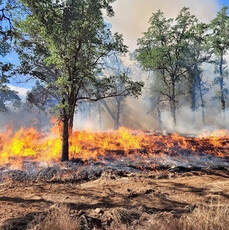 Drought conditions affect wildlife and fish as well. California Department of Fish and Wildlife (CDFW) staff at DWR’s Feather River Fish Hatchery successfully harvested additional Chinook salmon eggs this fall to offset drought impacts to the Feather River fishery and plans to plant an extra 1.7 million fish in 2022. CDFW staff in the Oroville Wildlife Refuge successfully timed their dry-land planting of grasses, flowers, and grains this spring where late spring rain resulted in over 140 acres of forage for both local and migrating birds. Wildfowl are also benefiting this winter from a public-private partnership between DWR, local organizations, and rice farmers to selectively flood rice paddies for support of the millions of migrating birds who travel the Pacific Flyway. 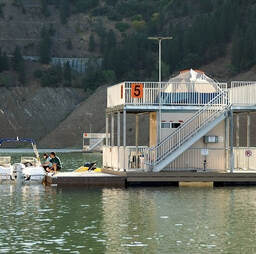 Fire again burned in the Feather River watershed where the Dixie Fire consumed nearly a million acres, requiring DWR to join in repeating last year’s North Complex Fire efforts to install erosion control measures to prevent toxic ash and burned materials from entering the waterways that supply Lake Oroville. DWR and OFD staff, as key members of the Feather River Watershed Working Group led by California Waterboards and Governor’s Office of Emergency Services, expanded the Department’s previous North Complex Fire work to address wildfire impacts on water quality. This included debris flow measurement, cleanup, and additional water sampling activities.  OFD also embarked on ambitious improvements including construction of a new boat ramp facility at Loafer Point with two stages reaching elevations of 800- and 681-feet elevation respectively to improve low water access, as well as added additional boat ramp lanes at Bidwell Canyon, including doubling the size of the Stage II boat ramp parking area.  Projects were also started to increase knowledge about the Feather River fishery and improve water control facilities such as the Thermalito Afterbay outlet and Palermo Tunnel intake in Lake Oroville. OFD staff also closely collaborated with CAL FIRE and local partners to address acres of burned and overgrown vegetation through DWR’s Fuel Load Management Program and CAL FIRE’s Vegetation Management Program.
DWR is looking forward to initiating and completing more projects in 2022 at the Oroville-Thermalito Complex. The Lake Oroville Community Update will continue to share news and information with the community. Your thoughts, comments, and questions to oroville@water.ca.gov are always welcome. Current Lake Operations The elevation of Oroville’s reservoir is about 689 feet elevation and storage is about 1.17 million acre-feet, which is 33 percent of its total capacity and 64 percent of historical average. Wet and cold conditions are forecasted this weekend into the early part of next week with up to four inches in the Feather River Basin Saturday through Tuesday. The higher elevations are expected to see heavy snow accumulation on Sunday with continued snow accumulation in the early part of the week. Inflows to Lake Oroville from the recent storm on Thursday and Friday have been upwards of around 20,000 cubic per second (cfs) and expected to be in the range of 7,000 cfs to 13,000 cfs during the weekend into next week . However, the storms are colder in the beginning of the week and inflows are subject to change based upon on actual weather conditions and snow elevations. Total flows to the Feather River are at 950 cfs for meeting downstream water quality and flow requirements. Flow in the low-flow channel, through the City of Oroville, is 650 cfs and flow through the Thermalito Afterbay Outlet is 300 cfs. Releases are assessed daily. The public can track precipitation, snow, reservoir levels, and more at the California Data Exchange Center at www.cdec.water.ca.gov. Lake Oroville is identified as “ORO”. All data as of midnight 12/22/2021 On behalf of all the staff of DWR and the Oroville Field Division, we would like to wish you and yours a very safe and healthy holiday season. The Lake Oroville Community Update will return on Jan. 7, 2022. ### Know someone who would like to receive Community Updates? They can email their request to oroville@water.ca.gov.  December 10, 2021 State Water Project Allocation The Department of Water Resources (DWR) announced the initial State Water Project (SWP) allocation for 2022 on Dec. 1, along with several steps to manage the state’s water supply in anticipation of a third dry year with reservoirs at or near historic lows. The Dec. 1 allocation will focus on the health and safety needs of the 29 water agencies that contract to receive SWP supplies. The SWP will not be planning water deliveries through its typical allocation process until the state has a clearer picture of the hydrologic and reservoir conditions going into the spring. (Hydrology is the study of movement of water in relation to land – including water from precipitation and snowmelt.) DWR is focused on prioritizing water supply in four categories: water for health and safety needs and Delta salinity control; water for endangered species; water to reserve in storage; and water for additional supply allocations if the hydrology allows. Water in Lake Oroville will be reserved to maintain Delta water quality, protect endangered species, and meet senior water right needs. Beyond minimal exports to meet South Bay health and safety needs, water stored in Lake Oroville will be used for south of Delta deliveries only if hydrology conditions improve. South of Delta deliveries will be met with water available from the Delta as well as water stored in San Luis Reservoir. The full news release can be viewed on the DWR News Releases webpage. Oroville Dam Citizens Advisory Commission Public Meeting The California Natural Resources Agency (CNRA) held its ninth Oroville Dam Citizens Advisory Commission meeting on Dec. 3, 2021. The online public meeting included presentations about downstream flood management and preparedness as well as an update on the Water Control Manual from a representative of the U.S. Army Corps of Engineers. Members of the public also offered comments and asked questions. The Citizens Advisory Commission is a forum to provide public feedback from the communities surrounding Oroville Dam. The meeting transcript and presentations will be available on the Commission’s website in the coming weeks at https://bit.ly/OrovilleCAC. New Invasive Plants Discovered Environmental scientists with the Department of Water Resources (DWR) Oroville Field Division have discovered a new aquatic invasive plant in the Feather River downstream of Oroville. The new floating aquatic plant is the South American spongeplant (Limnobium spongia), previously known from the Sacramento River and the Sacramento-San Joaquin Delta. This is the second new, high-rated (by the California Invasive Plant Council) invasive plant species DWR has discovered in the Feather River in the last three years. In 2019, alligator weed (Alternanthera philoxeroides) was found adjacent to the Feather River Outlet Boat Ramp. Neither of these species were previously known in Butte County but have been expanding in recent years across California. Aquatic invasive species (AIS) move from one area to another via watercraft, personal water gear, pets who have entered the water, and by wildlife. You can help minimize the spread of AIS by thoroughly inspecting all equipment after leaving a waterbody; clean any visible mud and plants from watercrafts, equipment, and personal gear; and drain water from all equipment, including bait buckets, and ballast tanks. Cleaning and drying anything that came in contact with water (including pets and clothing) will help prevent the spread of AIS. Invasive plants can de-stabilize dissolved oxygen cycles needed by fish and aquatic organisms, crowd out native plants, shade out crucial shallow-water fish habitat, obstruct waterways and navigational channels, and block agricultural and municipal water intakes. Photo: Top: South American Spongeplant (large round leaves) Bottom: Alligator Weed 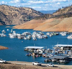 Loafer Creek Fuels Management Crews from CAL FIRE’s Butte Fire Center, along with crews from California Conservation Corps and the Butte County Sheriff Office, are continuing various fuel reduction projects using heavy equipment, hand cutting, chipping, and burning of prioritized overgrown vegetative areas within the Federal Energy Regulatory Commission (FERC) project boundary of DWR’s Oroville-Thermalito Complex. Hikers and equestrian users of the Roy Rogers Trail in the Loafer Creek recreation area, visitors to the area, and motorists along Highway 162 are advised to be mindful of safety when near work zones. Photo: Piling vegetation and burned trees into piles at Loafer Creek recreation area.  Oroville Recreation
Bidwell Canyon’s Stage III concrete boat ramp and the single-lane gravel boat ramp at Oroville Dam’s Spillway Boat Ramp area are open. The Spillway ramp will continue to be open as conditions permit. Boaters on the lake are advised to be aware of unexpected shallow water, obstruction hazards, and floating debris. The Lime Saddle Marina is now open for customer access, but with very limited services due to damage caused by the October storm event. At this time, the boat ramp remains out of the water. Access to boats and houseboats at both Bidwell Canyon and Lime Saddle marinas should be coordinated through the marina prior to arrival by calling (530) 589-9175 or by utilizing the shuttle service at Bidwell Canyon Marina. The Lake Oroville Visitor Center is open to the public on Tuesdays, Wednesdays, and Thursdays from 9 a.m. to 5 p.m. Visitors can tour the center’s educational exhibits and area grounds with trails and climb the 47-foot-tall viewing tower with great views of Lake Oroville, the Sierra, the valley, and Sutter Buttes. Please contact the VC Guides at (530) 538-2219 for more information. Numerous Day Use Area (DUA) facilities with picnic tables and restrooms at Lake Oroville State Recreation Area (LOSRA) are open 8 a.m. to sunset. Bidwell, Lime Saddle, and Loafer Creek recreation areas are open 24 hours. The Oroville Dam Crest Road across Oroville Dam is available 5 a.m. to 11 p.m. daily with the Spillway trailhead and boat launch open from 6 a.m. to 8 p.m. The top of the dam is open to pedestrians and bicyclists 24-hours a day. DWR’s new trail maps of over 97 miles of trails available to equestrians, bicyclists, and hikers wishing to explore Oroville’s natural beauty in the cooler fall weather are available at many Oroville locations including Lake Oroville State Recreation Area (LOSRA) kiosks, Oroville Wildlife Area office on Oro Dam Boulevard West, the Oroville Area Chamber of Commerce, and Feather River Recreation and Parks District. Visit the California Parks LOSRA webpage for current information on facility status and campground reservations. An interactive map of recreation facilities in DWR’s Oroville-Thermalito Complex is available on DWR’s Lake Oroville Recreation webpage. Information about the 11,000-acre Oroville Wildlife Area is available on the California Department of Fish and Wildlife webpage. Photo: Bidwell Canyon Stage III boat ramp at Lake Oroville State Recreation Area Current Lake Operations The elevation of Oroville’s reservoir is about 673 feet elevation and storage is about 1.06 million acre-feet, which is 30 percent of its total capacity and 59 percent of historical average. Heavy precipitation in Oroville and snow accumulation in the higher elevations are forecasted for the Feather River Basin beginning Sunday and extending into Monday with continuing snow showers into the higher elevations mid-week. The Feather River basin may see 5 to 7 inches as a result of these storms. Temperatures will range in the 20s and 30s in the higher elevations and upper 40s and low 50s in the valley. Inflows to Lake Oroville have been ranging around 500 to 1,000 cubic feet per second (cfs) and are expected to increase early next week in response to the heavy precipitation. Current forecasts indicate potential inflows of about 10,000 cfs (subject to change based upon on actual weather and soil conditions). At 30 percent capacity, there is sufficient storage to manage these inflows. Total flows to the Feather River are at 1,500 cubic feet per second (cfs) for meeting downstream water quality and flow requirements. Flow in the low-flow channel, through the City of Oroville, is 650 cfs and flow through the Thermalito Afterbay Outlet is 850 cfs. Releases are assessed daily. The public can track precipitation, snow, reservoir levels, and more at the California Data Exchange Center at www.cdec.water.ca.gov. Lake Oroville is identified as “ORO”. All data as of midnight 12/02/2021 ### Know someone who would like to receive Community Updates? They can email their request to oroville@water.ca.gov.  December 3, 2021 Oroville Dam Citizens Advisory Commission Public Meeting The California Natural Resources Agency (CNRA) held its ninth Oroville Dam Citizens Advisory Commission meeting on Dec. 3, 2021. The online public meeting included presentations about downstream flood management and preparedness as well as an update on the Water Control Manual from a representative of the U.S. Army Corps of Engineers. Members of the public also offered comments and asked questions. The Citizens Advisory Commission is a forum to provide public feedback from the communities surrounding Oroville Dam. The meeting transcript and presentations will be available on the Commission’s website in the coming weeks at https://bit.ly/OrovilleCAC. New Invasive Plants Discovered Environmental scientists with the Department of Water Resources (DWR) Oroville Field Division have discovered a new aquatic invasive plant in the Feather River downstream of Oroville. The new floating aquatic plant is the South American spongeplant (Limnobium spongia), previously known from the Sacramento River and the Sacramento-San Joaquin Delta. This is the second new, high-rated (by the California Invasive Plant Council) invasive plant species DWR has discovered in the Feather River in the last three years. In 2019, alligator weed (Alternanthera philoxeroides) was found adjacent to the Feather River Outlet Boat Ramp. Neither of these species were previously known in Butte County but have been expanding in recent years across California. Aquatic invasive species (AIS) move from one area to another via watercraft, personal water gear, pets who have entered the water, and by wildlife. You can help minimize the spread of AIS by thoroughly inspecting all equipment after leaving a waterbody; clean any visible mud and plants from watercrafts, equipment, and personal gear; and drain water from all equipment, including bait buckets, and ballast tanks. Cleaning and drying anything that came in contact with water (including pets and clothing) will help prevent the spread of AIS. Invasive plants can de-stabilize dissolved oxygen cycles needed by fish and aquatic organisms, crowd out native plants, shade out crucial shallow-water fish habitat, obstruct waterways and navigational channels, and block agricultural and municipal water intakes. Photo: Top: South American Spongeplant (large round leaves) Bottom: Alligator Weed Loafer Creek Fuels Management Crews from CAL FIRE’s Butte Fire Center, along with crews from California Conservation Corps and the Butte County Sheriff Office, are performing various fuel reduction projects using heavy equipment, hand cutting, chipping, and burning of prioritized overgrown vegetative areas within the Federal Energy Regulatory Commission (FERC) project boundary of DWR’s Oroville-Thermalito Complex. Hikers and equestrian users of the Roy Rogers Trail in the Loafer Creek recreation area, visitors to the area, and motorists along Highway 162 are advised to be mindful of safety when near work zones. 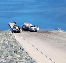 Oroville Recreation
Bidwell Canyon’s Stage III concrete boat ramp and the single-lane gravel boat ramp at Oroville Dam’s Spillway Boat Ramp area are open. The Spillway ramp will continue to be open as conditions permit. Boaters on the lake are advised to be aware of unexpected shallow water, obstruction hazards, and floating debris. The Lime Saddle Marina is now open for customer access, but with very limited services due to damage caused by the October storm event. At this time, the boat ramp remains out of the water. Access to boats and houseboats at both Bidwell Canyon and Lime Saddle marinas should be coordinated through the marina prior to arrival by calling (530) 589-9175 or by utilizing the shuttle service at Bidwell Canyon Marina. The Lake Oroville Visitor Center is open to the public on Tuesdays, Wednesdays, and Thursdays from 9 a.m. to 5 p.m. Visitors can tour the center’s educational exhibits and area grounds with trails and climb the 47-foot-tall viewing tower with great views of Lake Oroville, the Sierra, the valley, and Sutter Buttes. Please contact the VC Guides at (530) 538-2219 for more information. Numerous Day Use Area (DUA) facilities with picnic tables and restrooms at Lake Oroville State Recreation Area (LOSRA) are open 8 a.m. to sunset. Bidwell, Lime Saddle, and Loafer Creek recreation areas are open 24 hours. The Oroville Dam Crest Road across Oroville Dam is available 5 a.m. to 11 p.m. daily with the Spillway trailhead and boat launch open from 6 a.m. to 8 p.m. The top of the dam is open to pedestrians and bicyclists 24-hours a day. DWR’s new trail maps of over 97 miles of trails available to equestrians, bicyclists, and hikers wishing to explore Oroville’s natural beauty in the cooler fall weather are available at many Oroville locations including Lake Oroville State Recreation Area (LOSRA) kiosks, Oroville Wildlife Area office on Oro Dam Boulevard West, the Oroville Area Chamber of Commerce, and Feather River Recreation and Parks District. Visit the California Parks LOSRA webpage for current information on facility status and campground reservations. An interactive map of recreation facilities in DWR’s Oroville-Thermalito Complex is available on DWR’s Lake Oroville Recreation webpage. Information about the 11,000-acre Oroville Wildlife Area is available on the California Department of Fish and Wildlife webpage. Photo: Boaters launching at Lake Oroville State Recreation Area's Bidwell Canyon Stage III boat ramp Current Lake Operations The elevation of Oroville’s reservoir is about 672 feet elevation and storage is about 1.05 million acre-feet, which is 30 percent of its total capacity and 60 percent of historical average. The current forecast indicates mainly dry conditions through the weekend and into next week with possible rain later in the week. Temperatures will range in the upper 50s- to low-60s this weekend and continuing into next week. Total flows to the Feather River are at 1,500 cubic feet per second (cfs) for meeting downstream water quality and flow requirements. Flow in the low-flow channel, through the City of Oroville, is 650 cfs and flow through the Thermalito Afterbay Outlet is 850 cfs. Releases are assessed daily. The public can track precipitation, snow, reservoir levels, and more at the California Data Exchange Center at www.cdec.water.ca.gov. Lake Oroville is identified as “ORO”. All data as of midnight 12/02/2021 ### Know someone who would like to receive Community Updates? They can email their request to oroville@water.ca.gov. |
Archives
October 2023
Categories
All
|

 RSS Feed