 Lake Oroville Water Releases Continue The Department of Water Resources (DWR) continues to make releases from Lake Oroville using the main spillway at Oroville Dam. Ongoing releases ensure continued storage space in Lake Oroville for spring runoff from rain and snowmelt and are closely coordinated with the U.S. Army Corps of Engineers and downstream water operators. Total releases to the Feather River amount to 7,500 cubic feet per second (cfs) with 1,000 cfs being routed down the low-flow channel which flows through the City of Oroville. An additional 6,500 cfs is being released from the Thermalito Afterbay River Outlet, located 5 miles downstream from Oroville. DWR continues to closely monitor lake levels and will adjust releases accordingly. Releases to the Feather River may be increased temporarily in the coming weeks to assist with fish planting operations. Since Dec. 1, Lake Oroville’s storage has increased approximately 200 feet and gained just under 2 million acre-feet of water. The Lake Oroville reservoir is the largest storage facility in the State Water Project (SWP) and supports environmental and water delivery needs to 27 million Californians and reduces flood risks to downstream communities. DWR continues to monitor lake levels, weather forecasts, and mountain snow levels to optimize operations for water storage and environmental protection while allowing for carryover storage into next year. 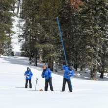 DWR CONDUCTS APRIL SNOW SURVEY DWR conducted the fourth snow survey of the season at Phillips Station on April 3. The manual survey recorded 126.5 inches of snow depth and a snow water equivalent of 54 inches, which is 221 percent of average for this location on April 3. The snow water equivalent measures the amount of water contained in the snowpack and is a key component of DWR’s water supply forecast. DWR’s electronic readings from 130 snow sensors placed throughout the state indicate the statewide snowpack’s snow water equivalent is 61.1 inches, or 237 percent of average for this date. This year’s April 1 result from the statewide snow sensor network is higher than any other reading since the snow sensor network was established in the mid-1980s. Before the network was established, the 1983 April 1 statewide summary from manual snow course measurements was 227 percent of average. The 1952 April 1 statewide summary for snow course measurements was 237 percent of average. “This year’s result will go down as one of the largest snowpack years on record in California,” said Sean de Guzman, manager of DWR’s Snow Surveys and Water Supply Forecasting Unit. “While 1952’s snow course measurements showed a similar result, there were fewer snow courses at that time, making it difficult to compare to today’s results. Because additional snow courses were added over the years, it is difficult to compare results accurately across the decades with precision, but this year’s snowpack is definitely one of the biggest the state has seen since the 1950s.” For more information about the April snow survey, read DWR’s press release.  EARTH WEEK ACTIVITIES Celebrate Earth Week at the Lake Oroville Visitor Center April 17-21. Join our guides for fun, family-friendly activities throughout the week. Each day is an opportunity to show your love for our planet and its precious water through free fun activities, engaging story times, movies, or crafts. Located at 917 Kelly Ridge Rd in Oroville, the Visitor Center is open Monday through Friday from 9 a.m. to 5 p.m.
 OROVILLE RECREATION
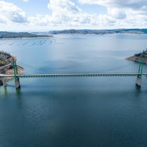
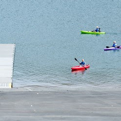
DWR, State Parks, and CDFW maintain over 92 miles of trails in the Oroville area. Paved trails at the Lake Oroville Visitor Center, Spillway Day Use Area, and at the North Forebay Day Use Area offer accessible trails with only slight elevation changes. Other trails, such as the Brad Freeman Trail near Oroville Dam, offer steep elevation changes to challenge hikers and mountain bikers. The Saddle Dam Trailhead has facilities for equestrians, including a large parking area to accommodate horse trailers, water troughs, and hitching posts, and easy access to trails designated for hikers and horses. An interactive map of recreation facilities, including open boat ramps, and their permitted uses (hike, bike, horse, multi) is available on DWR’s Lake Oroville Recreation webpage. A paper trail map is available at various locations, including most entrance kiosks and the Visitor Center. The marinas at Bidwell Canyon and Lime Saddle are open daily and provide a variety of services such as a shuttle and boat rentals. CURRENT LAKE OPERATIONS Lake Oroville is at 860 feet elevation and storage is approximately 2.94 million acre-feet (MAF), which is 83 percent of its total capacity and 115 percent of the historical average. Dry weather conditions will be returning to the area next week. The Feather River releases are at 7,500 cubic feet per second (cfs). Flows through the City of Oroville are 1,000 cfs with 6,500 cfs released from the Thermalito Afterbay Outlet (Outlet) for a total of 7,500 cfs downstream of the Outlet. DWR continues to assess releases to the Feather River daily. The public can track precipitation, snow, reservoir levels, and more at the California Data Exchange Center. The Lake Oroville gage station is identified as “ORO”. All data as of midnight 4/6/2023. Comments are closed.
|
Archives
October 2023
Categories
All
|

 RSS Feed