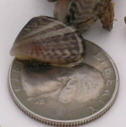
 June 10, 2022 Protecting Against Quagga and Zebra Mussels As boating season kicks off, The Department of Water Resources (DWR), California State Parks’ Division of Boating and Waterways (DBW), and California Department of Fish and Wildlife (CDFW) urge boaters to always remember to clean, drain, and dry their boats before entering and leaving lakes, rivers, and other waterways to help prevent the spread of quagga or zebra mussels. These two non-native freshwater mollusks – quagga and zebra mussels – pose a serious threat to California’s aquatic ecosystems. Quagga and zebra mussels are small, invasive species that colonize on hard surfaces, such as boat hulls and pontoons, docks and pilings, rocks, concrete, plastics, and even discarded bottles and cans. DWR’s Oroville Field Division biologists regularly sample Lake Oroville -for indicators the mollusks are present and, to date, none have been found. Quagga and zebra mussels can be spread to new waterbodies when attached to boats as adults, or as microscopic juveniles in water in motors, bilges, and livewells. They are smaller than a dime, and juvenile mussels may even be difficult to detect with the naked eye. Despite their small size, they can cause major damage to water delivery systems, hydroelectric facilities, and watercraft engines. When boating, make it a habit to do the following:
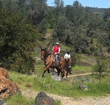
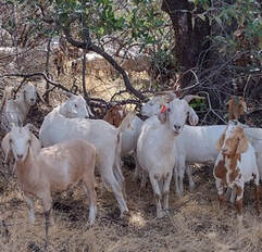
SOUTH FOREBAY CLOSED The California Department of Parks and Recreation (CA Parks) announced today the South Forebay and the Nelson Bridge Day Use Area will be closed from 8 a.m. Saturday, June 11 to 8 a.m. Monday, June 13 for a private boat racing event. Entrances to the South Forebay at Grand Avenue, Nelson Avenue Bridge Day Use Area and behind Poplar Avenue Elementary School will be closed, including the levee system to the east and south of the forebay. CA Parks has closed these areas to public use, entry, or occupancy.  CAL FIRE CONTROL BURNS In cooperation with DWR and CA Parks, CAL FIRE conducted control burns around the North Forebay, the Nelson Sports Complex, and along Grand Avenue this past week. The vegetation management-control burns have multiple beneficial impacts for the natural environment and public safety. Around the Thermalito Forebay are many seasonal wetlands called vernal pools which support a high diversity of California native plants and animals, including rare and endangered species and species endemic to California (i.e., found nowhere else in the world). Fire from carefully controlled burns is the most powerful tool to combat invasive plants and dry invasive grass buildup called ‘thatch’ within these grasslands and vernal pools, as well as from grassland adjacent to private property and near high-use areas. Additional plots may be burned over the next two weeks at Loafer Creek Recreation Area as weather conditions allow. Smoke will be visible at times in the Kelly Ridge and Greater Oroville areas throughout the duration of the project.  OROVILLE RECREATION The Lake Oroville State Recreation Area (LOSRA) is open for boating, camping, hiking, biking, horseback riding, and much more. The four main paved boat ramps at Lime Saddle, Bidwell Canyon, Spillway, and Loafer Point are open, along with the Lime Saddle and Bidwell Canyon marinas, and campground reservations can be made by visiting the CA Parks LOSRA website. Restrooms, potable water, and fish cleaning stations are not in service at the Spillway Boat Ramp area but portable toilets are provided – please plan visits accordingly. The Thermalito Forebays and Afterbay also provide a wide range of water recreation opportunities along with hiking trails, the Clay Pit State Vehicular Recreation area for Off-Highway Vehicles (OHVs) (south of Oroville Airport), and the 11,000 acres of prime wildlife viewing in the Oroville Wildlife Area. The OWA is administered for DWR by the CDFW and information about the 11,000-acre Oroville Wildlife Area is available on the CDFW webpage. The Forebay Aquatic Center in the North Forebay Recreation Area is open 10 a.m. to 8 p.m. Friday to Sunday with kayaks, paddle boards, and other watercraft available for rent. An interactive map of recreation facilities in DWR’s Oroville-Thermalito Complex is available on DWR’s Lake Oroville Recreation webpage. Visitors are encouraged to be fire smart, bring plenty of sunscreen, stay hydrated, avoid leaving valuables in visible areas, be prepared for cold water temperatures, and be mindful of personal safety and the safety of those around you.  GRAZING EFFORTS REDUCE FIRE RISK More than 100 goats and sheep continue to provide vegetation management along Canyon Drive from Royal Oaks Drive to Oroville Dam’s Upper Overlook Parking Area as part of DWR’s Fuel Load Management Plan to reduce wildfire risk, increase public safety, and enhance forest health in areas around Lake Oroville. To increase the amount of vegetation removed, a mixture of goats and sheep are used by contractor Hanski Family Farms because the animals prefer different vegetation types. Goats prefer ladder fuels (shrubs, bushes, smaller trees, or tree branches near the ground) and sheep prefer grasses. When goats stand on their hind legs, they can reduce ladder fuels up to six feet high. DWR, in partnership with Butte County Fire Safe Council, continues to use grazing as a sustainable method of fuel reduction around DWR’s Oroville-Thermalito Complex, including Lake Oroville. CURRENT LAKE OPERATIONS The elevation of Oroville’s reservoir is about 770 feet elevation and storage is about 1.87 million acre-feet (MAF), which is 53 percent of its total capacity and 68 percent of historical average. The forecast calls for a chance of rain over the weekend with dry conditions next week. Temperatures are forecasted to be in the low-100s on Saturday and will be dropping beginning on Sunday into next week. Temperatures are expected to fluctuate from the low-80s-to-mid-90s through the week. The Feather River releases were increased last week and are currently at 3,500 cubic feet per second (cfs) to meet downstream Delta water quality and outflow needs. Currently, flows down the low flow channel through the City of Oroville have increased to 1,450 cfs and 2,050 cfs is being released from the Thermalito Afterbay Outlet (Outlet) for a total of 3,500 cfs downstream of the Outlet. Flows are assessed daily and may fluctuate through the low flow channel for fisheries purposes during the week. The public can track precipitation, snow, reservoir levels, and more at the California Data Exchange Center at www.cdec.water.ca.gov. The Lake Oroville gage station is identified as “ORO”. All data as of midnight 6/9/2022  California is entering its third year of drought conditions. With water conservation now a way of life in California, everyone is encouraged to find ways to save water. See tips, tools, and ideas on the Save Our Water website. Information about real time local hydrological conditions, forecasts, and water conditions is available on DWR’s new website California Water Watch. Comments are closed.
|
Archives
October 2023
Categories
All
|


 RSS Feed