 October 29, 2021 Historic Storm Impacts The recent series of atmospheric river (AR) storms, including a Category 5 AR Oct. 24-25 that set record-breaking rainfall totals across Northern California, dropped over 10 inches of rain in the Feather River watershed that supplies the Lake Oroville Reservoir. The reservoir’s elevation on Friday, Oct. 22 was 629 feet and by Wednesday, Oct. 27 had reached 658 feet, an increase of 29 feet. Inflows from the storm continue to arrive as the region prepares for another storm, making this one of the wettest Octobers on record. Lake Oroville’s historic low lake levels have exposed areas of the lakebed that have been underwater for decades, accumulating layers of silt that easily erode in heavy precipitation events. This type of erosion was very noticeable near the Bidwell Canyon Stage III boat ramp. The concrete boat ramp is not in any danger because it is built on a solid foundation of compacted gravel and armored along its slopes with large stones called riprap which reduce erosion impacts. Lake level rise will stop further erosion from occurring. Woody debris carried on inflows from each fork of the Feather River was about what is normally expected from heavy storms. The Department of Water Resources’ (DWR) Oroville Field Division’s Civil Maintenance crews are deploying log booms to restrict the movement of floating debris into the main body of the lake. These log booms will be repositioned over the coming months as lake elevations rise. Photo: October storm erosion at Bidwell Stage III boat ramp Oroville Recreation Advisory Committee The Oroville Recreation Advisory Committee will hold a public virtual meeting on Friday, Nov. 5 from 9 a.m. to noon. Interested persons can register for the meeting at https://ca-water-gov.zoom.us/meeting/register/tZcpd-mprTojGdFyLVFrSqQQxfBljOLERijl. Instructions for joining the meeting will be sent in the confirmation email. ORAC was established by the Federal Energy Regulatory Commission (FERC) to review and provide recommendations regarding DWR’s recreation plan for the P-2100 – Oroville Facilities. The 13-member committee is made up of representatives from state and local government, sports and recreation groups, and business and community organizations. Lakeside Access Road Construction The Lakeside Access Road project began this week. This project will consist of a new, permanent, paved road from the west side of Oroville Dam to the Spillway Boat Ramp parking lot on the “lakeside,” or waterside, of the Oroville Dam spillways. This new road will allow a more direct route when water levels are low in Lake Oroville (below 800 feet elevation). The new road will include two concrete traffic lanes, wide shoulders for walking and biking, guardrails, and safety signage. Additionally, the contractor will be removing and replacing deteriorating asphalt from the Stage I Spillway Boat Ramp. Visitors to Oroville Dam can expect to see large construction equipment and material deliveries in the area through January as the contractor works to complete the project. Please use caution and respect the construction fencing and safety signage when visiting Oroville Dam or the Spillway Boat Ramp.  Water Quality Working Group In late fall of 2020, Butte County, the Governor’s Office of Emergency Services (CalOES), Department of Water Resources (DWR), State Water Resources Control Board and Regional Water Quality Control Boards (Water Boards), California Department of Fish and Wildlife, California Department of Parks and Recreation, and local water purveyors formed the North Complex Watershed Working Group to monitor and evaluate watershed and infrastructure response to the North Complex wildfire from 2020. This working group has expanded its scope to include impacts from the 2021 Dixie Fire and will now be called the Feather River Watershed Working Group (Working Group). Additional partner agencies, including affected counties such as Plumas County, have joined others from local, state, and federal levels to coordinate regarding water quality and infrastructure impacts in the watershed. Members of the Working Group also provide technical guidance and expertise to local agencies and partners on water quality monitoring and protections in the post-fire environment. The Working Group is preparing for the upcoming rainy season and currently meets bi-weekly, with the option to increase meeting frequency as the season progresses. The Working Group will continue to provide the public with informational updates on watershed conditions and water quality testing results as they become available. The summary of last year’s findings can be found on the Water Boards’ July 8, 2021 news release. Photo: Water quality experts taking water samples for water quality testing after the North Complex fire (Oct. 2020)  Lake Oroville Boating The temporary, single-lane boat ramp at Oroville Dam’s Spillway Boat Ramp area has reopened for public use from 6 a.m. to 8 p.m. to launch trailered boats. Vehicles within the parking lot at closing time will be locked in until the next morning. Lake levels have and are expected to increase as a result of recent rainfall events. Boaters are advised to park vehicles and trailers well above lake level when boating on the lake. The spillway auxiliary ramp has a gravel surface which becomes slippery when wet, especially during times of heavy usage. To maintain the integrity of the ramp, drivers must avoid tire spin by placing vehicles in 4-wheel drive and accelerating slowly when exiting the ramp, with or without a loaded trailer. As weather conditions and lake levels change, the fitness of the ramp for continued use will be regularly assessed. Boaters on the lake are advised to be aware of unexpected shallow water and obstruction hazards such as partially submerged trees exposed by low lake levels. State Parks has issued an order for the Lake Oroville State Recreation Area (LOSRA) that boating access on Lake Oroville is not permitted starting one-half hour after sunset and ending one-half hour before sunrise due to navigational hazards. Houseboats and vessels remaining on the water must be on their mooring ball or in a slip during hours of lake closure. Additional information can be obtained by calling State Parks at (530) 538-2200. All access to boats and houseboats at both Bidwell Canyon and Lime Saddle Marinas must be coordinated through the marina prior to arrival by calling (530)589-9175 or by utilizing the shuttle service at Bidwell Canyon Marina. Shuttle services to Lime Saddle Marina is not being provided at this time. The Thermalito Afterbay and Thermalito South Forebay continue to be open to power boating. Photo: Fishing on Lake Oroville 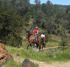 Oroville Recreation Numerous Day Use Area (DUA) facilities with picnic tables and restrooms at Lake Oroville State Recreation Area (LOSRA) are open 8 a.m. to sunset. Bidwell, Lime Saddle, and Loafer Creek recreation areas are open 24 hours. The Oroville Dam Crest Road across Oroville Dam is available 5 a.m. to 11 p.m. daily with the Spillway trailhead and boat launch open from 6 a.m. to 8 p.m. The top of the dam is open to pedestrians and bicyclists 24-hours a day. The Lake Oroville Visitor Center anticipates re-opening later this year. Over 97 miles of trails around Lake Oroville, along the Feather River, Thermalito Diversion Pool, Forebays and Afterbay, and the Oroville Wildlife Area are available to equestrians, bicyclists, and hikers wishing to explore Oroville’s natural beauty in the cooler fall weather. Trail maps are available at many Oroville locations including Lake Oroville State Recreation Area (LOSRA) kiosks, Oroville Wildlife Area office on Oro Dam Boulevard West, the Oroville Area Chamber of Commerce, and Feather River Recreation and Parks District. The Forebay Aquatic Center at the North Forebay recreation area has closed for the season but the recreation area remains open with picnic tables, restrooms, and beach facilities. Visit the California Parks LOSRA webpage for current information on facility status and campground reservations. An interactive map of recreation facilities in DWR’s Oroville-Thermalito Complex is available on DWR’s Lake Oroville Recreation webpage. Information about the 11,000-acre Oroville Wildlife Area is available on the California Department of Fish and Wildlife webpage. Photo: Trail marker on the Dan Beebe Trail near the Saddle Dam trailhead  Be Flood Prepared
More than seven million California residents are at risk of flooding, and many don’t realize it. Flooding happens throughout the state; every California county has received a flood-related emergency declaration in the past 20 years and flood events during and after drought conditions are not uncommon. Make sure you are prepared for flood events through these three steps:
This year, many communities are at additional risk for flooding because of wildfire damage as evidenced by this week’s National Weather Service’s Flash Flood Watch for the North Complex and Dixie wildfire burn scar areas. Wildfires dramatically change the landscape and ground conditions in a watershed. Natural, unburned vegetation and soil normally act as a sponge during a rainfall event. However, the heat from a fire can bake the ground, creating a surface that will not absorb water and can increase the speed with which water flows off the slope, leading to damaging, and sometimes catastrophic, mud and debris flows. These conditions can be present for years after a wildfire. Visit DWR’s Flood Preparedness webpage for information about keeping you, your loved ones, and community safe. Current Lake Operations The elevation of Oroville’s reservoir is about 659 feet elevation and storage is about 970,000-acre-feet, which is 27 percent of its total capacity and 53 percent of historical average. Water year 2022, which started on Oct. 1 and ends on Sept. 31, 2022, started off with a series of atmospheric river storms making landfall in northern California. So far, Lake Oroville has seen a rise of about 30 feet and an increase in storage of 170 thousand acre-feet with continuing incremental storage gains. The current forecast indicates dry conditions over the weekend and chance of rain, up to 0.5 inch during the week of Nov. 1 with temperatures in the low to mid-60’s. To manage increased flows in the Oroville Complex, on Oct. 24, DWR increased the total releases from the Thermalito Afterbay Outlet to 2,500 cubic feet per second (cfs) for a total of 3,150 cfs total to the Feather River. Beginning on Oct. 25, DWR has been ramping down total releases to the Feather River. As of Oct. 29, total flows to the Feather River are 1,500 cfs for meeting downstream water quality and flow requirements. Flow in the low-flow channel, through the City of Oroville, is 650 cfs and flow through the Thermalito Afterbay Outlet is 850 cfs. Releases are assessed daily and continued release reductions are expected to conserve water. The public can track precipitation, snow, reservoir levels, and more at the California Data Exchange Center at www.cdec.water.ca.gov. Lake Oroville is identified as “ORO”. All data as of midnight 10/28/2021 ### Know someone who would like to receive Community Updates? They can email their request to [email protected]. Comments are closed.
|
Archives
October 2023
Categories
All
|

 RSS Feed