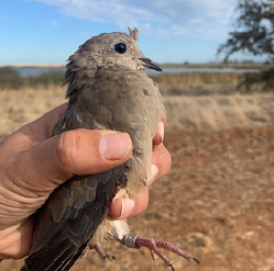
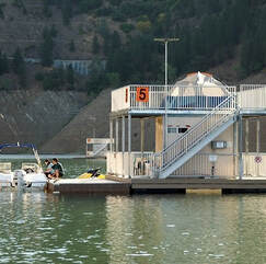
 August 19, 2022 Tracking Dove PopulationsStaff from the California Department of Fish and Wildlife (CDFW), along with assistance from California Department of Water Resources (DWR) staff, have been in the Oroville Wildlife Area (OWA) since July 11 to collect information on the local mourning dove population. Working in the safflower and sunflower fields in the OWA, that were planted by CDFW staff to provide a readily available food source for doves and many other bird species, staff successfully captured and placed identifying bands on 33 doves. Mourning doves are an important migratory game bird and California is one of 39 states participating in a national effort to monitor the mourning dove population in order to better estimate annual survival and guide harvest-management decisions. CDFW and DWR staff record the sex and approximate age of each banded bird and place a metal band with a unique identification number and a toll-free phone number to report the band around the dove’s leg. The hunter is the critical link in the dove banding study. Their reporting of the dove’s leg band enables wildlife managers to understand the effects of annual hunting regulations on mourning dove populations and allows for greater understanding of their migratory patterns. The Oroville Wildlife Area is a popular hunting location and CDFW expects 80 to 100 opening day hunters when Dove season opens on Sept. 1. For more information on CDFW activities in the OWA to increase forage for local and migratory birds, visit the DWR Updates webpage and search “sunflower” to access the digital article and previous stories in the Lake Oroville Community Update newsletter.  CHINOOK SALMON RETURN TO THE FEATHER RIVER Chinook salmon are completing their life cycle and returning home to the Feather River to lay eggs for the next generation of salmon. The Feather River Fish Hatchery plans to open up the fish ladder the week of Sept. 12 to begin hatchery spawning operations which enables millions of Chinook salmon to be released to the river every spring. Visitors to the Hatchery’s Fish Barrier Dam Overlook Viewing Area can watch salmon jumping and after the fish ladder opens in mid-September, visitors can watch salmon swim up the ladder at the Underwater Viewing window. The Overlook is located off Table Mountain Boulevard north of the Hatchery. Visitors are also encouraged to visit the Hatchery (open daily 8 a.m. to 3 p.m.) and attend the 28th Annual Salmon Festival in Oroville on Sept. 24. WATER SUPPLY STRATEGY Last week, Governor Gavin Newsom announced California’s latest actions to increase water supply and adapt to more extreme weather patterns caused by climate change. The actions, outlined in a strategy document called “California’s Water Supply Strategy, Adapting to a Hotter, Drier Future” (Strategy), follows $8 billion in state investments over the last two years to help store, recycle, de-salt, and conserve the water needed to keep up with the increasing pace of climate change. The strategy calls for investing in new sources of water supply, accelerating projects, and modernizing how the state manages water through the use of new technologies. Strategies to rebuild the way we source, store, and deliver water include creating storage space above and below ground to capitalize on big storms when they do occur, better recycling and safer reuse of wastewater currently discharged into the ocean, becoming more efficient water users through conservation, desalination efforts – especially of brackish groundwater which requires significantly less energy to treat than seawater, and groundwater recharge. An additional $2.8 billion in the 2022-23 budget for drought relief to hard hit communities, water conservation, environmental protection for fish and wildlife, and long-term projects to permanently strengthen drought resilience will help combat the accelerating impacts of the warming climate on our water supply. Governor Newsom anticipates working with the Legislature to achieve statewide goals by creating local solutions through collaboration within and across watersheds. The news release and link to the Strategy report is available on the Office of the Governor’s newsroom webpage.  BLUE GREEN ALGAE MONITORING DWR environmental scientists regularly monitor Lake Oroville, the Thermalito North Forebay, and the Thermalito Afterbay for blue-green algae and their toxins, taking water samples from various locations regularly from Memorial Day through Labor Day. There are currently no harmful algal bloom (HAB) advisories for Lake Oroville, the Thermalito Forebay, or the Thermalito Afterbay. If elevated levels of cyanobacteria toxins are found, DWR staff work with California’s Regional Water Quality Control Board and recreation area managers to notify the public and post advisory signs at affected waterbodies. To learn more about HABs, or to report a HAB, visit the Water Board’s website. Blue-green algae (cyanobacteria) is a natural component of ecosystems. Under certain conditions, including warmer temperatures and increased nutrient loads, algae can grow rapidly causing “blooms.” Algal blooms sometimes produce toxins that can be harmful to people and animals. Visit this comparison chart on the HABs website for additional information.  OROVILLE RECREATION The Lake Oroville area has over 92 miles of trails, open to hiking, with some also allowing for horseback riding, some also allowing biking, and some designated for “multi-use” where all three activities may occur on the same trail. The trails provide users with spectacular views of Lake Oroville and the valley, home to the Sutter Buttes – named the smallest mountain range in the world. Trails and their permitted uses, day use areas, boat ramps and other recreation facilities are featured on DWR’s interactive map on DWR’s Lake Oroville Recreation webpage. Step inside the Lake Oroville Visitor Center, open Tuesday through Thursday from 9 a.m. to 5 p.m., to learn about the State Water Project and history of the area. At Lake Oroville, the Lime Saddle, Bidwell Canyon, Spillway, and Loafer Point boat ramps are open, along with the Lime Saddle and Bidwell Canyon marinas. Reservations for campgrounds in the Lake Oroville State Recreation Area (LOSRA) can be made by visiting the California Department of Parks and Recreation (CA Parks) LOSRA website. The Thermalito Forebay and Afterbay also provide a wide range of recreation opportunities including fishing, hiking, biking and boating. Non-motorized boating is permitted in the North Forebay, and motorized boating is permitted in the South Forebay and Afterbay. The North Forebay Aquatic Center has kayaks, paddle boards, and other watercraft available for rent. Non-motorized boating is also permitted in the Thermalito Diversion Pool with kayak access just before the restroom on Cherokee Road. Lake Oroville and the Oroville Wildlife Area also have car-top boat launch areas. CURRENT LAKE OPERATIONS The elevation of Oroville’s reservoir is about 713 feet elevation and storage is about 1.35 million acre-feet (MAF), which is 38 percent of its total capacity and 62 percent of historical average. Temperatures are forecasted to continue in the low-100s through the weekend and slightly dropping to the high-90s next week. The Feather River releases are currently at 3,000 cubic feet per second (cfs) to meet downstream Delta water quality and outflow needs. Flows through the City of Oroville are 1,000 cfs with 2,000 cfs released from the Thermalito Afterbay Outlet (Outlet) for a total of 3,000 cfs downstream of the Outlet. Flows through the low flow channel may fluctuate through the week for fisheries purposes. The public can track precipitation, snow, reservoir levels, and more at the California Data Exchange Center at www.cdec.water.ca.gov. The Lake Oroville gage station is identified as “ORO”. All data as of midnight 8/18/2022  California is in its third year of drought conditions. With water conservation now a way of life in California, everyone is encouraged to find ways to save water. See tips, tools, and ideas on the Save Our Water website. Information about real time local hydrological conditions, forecasts, and water conditions is available on DWR’s new website California Water Watch.
July 29, 2022 Oroville Dam Citizens Advisory Commission Meeting The California Natural Resources Agency held its 11th Oroville Dam Citizens Advisory Commission meeting on July 29, 2022. The public meeting at Oroville’s Southside Community Center included a brief update on the development of the Commission report, a recap of a flood safety stakeholder technical workshop held in April, and a presentation from the California Department of Water Resources (DWR) on dam facilities management and annual maintenance planning. Members of the public offered comments and asked questions. The Oroville Dam Citizens Advisory Commission is a forum for questions and feedback from the communities surrounding Oroville Dam. The meeting transcript and presentations will be available on the Commission’s website in the coming weeks at https://bit.ly/OrovilleCAC. 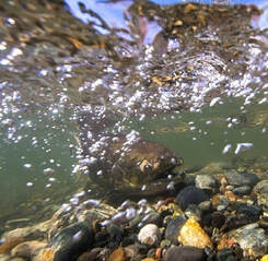 WATER SAFETY The hot weather is pushing more people to visit and explore our local waterways, lakes, and reservoirs, including the Feather River and Lake Oroville. Boaters are reminded to place safety as their top priority by making sure they and their passengers are wearing life jackets. U.S. Coast Guard statistics show that 80 percent of all drowning victims were not wearing a life jacket. Abiding by posted speed limits and signage, particularly regarding locations where swimming is prohibited such as in marinas or near boat docks or launch ramps, as well as paying attention to warning buoys, especially in reservoirs or other waterbodies with fluctuating water elevations, can greatly increase the safety of those with and around you. Lake Oroville has a lake-wide 5-mph speed limit at nighttime and personal watercraft or jet skis are prohibited from nighttime operation, even if they have navigation lights. Hours of operation at Thermalito Afterbay are 1.5 hours before sunrise to one hour after sunset. Boaters there are reminded of that waterbody’s 5-mph limit north of the Highway 162 bridge and within 200 yards of shore for all waterbodies in California. Water enthusiasts are also reminded that, even on a hot day, the water temperature can be cold and trigger cold water immersion shock. Cold water reduces body heat 25 to 30 times faster than air does at the same temperature and can quickly turn a good time into a life-threatening situation. Knowing the symptoms of hypothermia (when your body loses heat faster than it be produced) such as uncontrollable shivering, blue lips, clumsiness or lack of coordination, or bright red, cold skin, particularly among children who may be unaware of, or desire to ignore, their symptoms, can prevent a tragedy from occurring. If you suspect you or someone else is having these symptoms, act quickly to get out of the water, seek help, and begin gradual warming of the body. Taking sensible and even extra precautions when recreating around or in the water will help keep you and your family safe this summer. For more information on boating requirements and safety, visit the California Division of Boating and Waterways and cold-water safety tips at the National Weather Service’s Safety webpage.  OROVILLE RECREATION The Lake Oroville area has over 92 miles of trails, many open to horseback riding, with spectacular views of Lake Oroville and the valley, home to the Sutter Buttes – named the smallest mountain range in the world. Trails, permitted uses, day use areas, boat ramps and other recreation facilities are featured on DWR’s interactive map on DWR’s Lake Oroville Recreation webpage. And step inside the Lake Oroville Visitor Center, open Tuesday through Thursday from 9 a.m. to 5 p.m., to learn about the State Water Project and history of the area. At Lake Oroville, the Lime Saddle, Bidwell Canyon, Spillway, and Loafer Point boat ramps are open, along with the Lime Saddle and Bidwell Canyon marinas, and reservations for campgrounds in the Lake Oroville State Recreation Area (LOSRA) can be made by visiting the California Department of Parks and Recreation (CA Parks) LOSRA website. The Thermalito Forebay and Afterbay also provide a wide range of recreation opportunities including fishing, hiking, biking and boating. Non-motorized boating is permitted in the North Forebay, and motorized boating is only permitted in the South Forebay and Afterbay. The North Forebay Aquatic Center has kayaks, paddle boards, and other watercraft available for rent. Non-motorized boating is also permitted in the Thermalito Diversion Pool with kayak access just before the restroom on Cherokee Road. Lake Oroville and the Oroville Wildlife Area also have car-top boat launch areas.  BLUE GREEN ALGAE MONITORING DWR environmental scientists regularly monitor for blue-green algae and their toxins during the summer months. There are currently no harmful algal bloom (HAB) advisories for Lake Oroville, the Thermalito Forebay, or the Thermalito Afterbay. Water samples are taken at various locations regularly from Memorial Day through Labor Day. To learn more about HABs, or to report a HAB visit the Water Board’s website. CURRENT LAKE OPERATIONS The elevation of Oroville’s reservoir is about 727 feet elevation and storage is about 1.47 million acre-feet (MAF), which is 42 percent of its total capacity and 62 percent of historical average. Temperatures are forecasted to continue in the low 100s through the weekend and into next week. The Feather River releases are currently at 3,750 cubic feet per second (cfs) to meet downstream Delta water quality and outflow needs. Flows through the City of Oroville are 1,300 cfs with 2,450 cfs released from the Thermalito Afterbay Outlet (Outlet) for a total of 3,750 cfs downstream of the Outlet. Flows through the low flow channel may fluctuate through the week for fisheries purposes. The public can track precipitation, snow, reservoir levels, and more at the California Data Exchange Center at www.cdec.water.ca.gov. The Lake Oroville gage station is identified as “ORO”. All data as of midnight 7/28/2022  California is entering its third year of drought conditions. With water conservation now a way of life in California, everyone is encouraged to find ways to save water. See tips, tools, and ideas on the Save Our Water website. Information about real time local hydrological conditions, forecasts, and water conditions is available on DWR’s new website California Water Watch.
 July 22, 2022 Water Safety The hot weather is pushing more people to visit and explore our local waterways, lakes, and reservoirs, including the Feather River and Lake Oroville. Boaters are reminded to place safety as their top priority by making sure they and their passengers are wearing life jackets. U.S. Coast Guard statistics show that 80 percent of all drowning victims were not wearing a life jacket. Abiding by posted speed limits and signage, particularly regarding locations where swimming is prohibited such as in marinas or near boat docks or launch ramps, as well as paying attention to warning buoys, especially in reservoirs or other waterbodies with fluctuating water elevations, can greatly increase the safety of those with and around you. Lake Oroville has a lake-wide 5-mph speed limit at nighttime and personal watercraft or jet skis are prohibited from nighttime operation, even if they have navigation lights. Hours of operation at Thermalito Afterbay are 1.5 hours before sunrise to one hour after sunset. Boaters there are reminded of that waterbody’s 5-mph limit north of the Highway 162 bridge and, for all waterbodies, within 200 yards of shore. Water enthusiasts are also reminded that, even on a hot day, the water temperature can be cold and trigger cold water immersion shock. Cold water reduces body heat 25 to 30 times faster than air does at the same temperature and can quickly turn a good time into a life-threatening situation. Knowing the symptoms of hypothermia (when your body loses heat faster than it be produced) such as uncontrollable shivering, blue lips, clumsiness or lack of coordination, or bright red, cold skin, particularly among children who may be unaware of, or desire to ignore, their symptoms, can prevent a tragedy from occurring. If you suspect you or someone else is having these symptoms, act quickly to get out of the water, seek help, and begin gradual warming of the body. Taking sensible and even extra precautions when recreating around or in the water will help keep you and your family safe this summer. For more information on boating requirements and safety, visit the California Division of Boating and Waterways and cold-water safety tips at the National Weather Service’s Safety webpage. Oroville Dam Citizens Advisory Commission Meeting The California Natural Resources Agency is hosting its 11th Oroville Dam Citizens Advisory Commission meeting on July 29, 10 a.m. to Noon. The public meeting will be held at the Southside Community Center in Oroville, located at 2959 Lower Wyandotte Road, Oroville, CA 95966, and will include presentations and public comment. The Commission will receive a brief update on the development of the Commission report, a recap of a flood safety stakeholder technical workshop held in April, and a presentation from the California Department of Water Resources (DWR) on dam facilities management and annual maintenance planning. Time for public input is also scheduled. The Oroville Dam Citizens Advisory Commission is a forum for questions and feedback from the communities surrounding Oroville Dam. For information on the meeting, please visit https://bit.ly/OrovilleCAC. 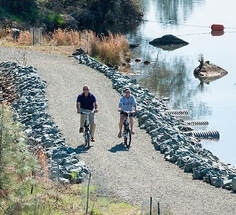 OROVILLE RECREATION Four paved boat ramps at Lime Saddle, Bidwell Canyon, Spillway, and Loafer Point are open at Lake Oroville, along with the Lime Saddle and Bidwell Canyon marinas, and reservations for campgrounds in the Lake Oroville State Recreation Area (LOSRA) can be made by visiting the California Department of Parks and Recreation (CA Parks) LOSRA website. Restrooms, potable water, and fish cleaning stations are not in service at the Spillway Boat Ramp area, but portable toilets are provided – please plan visits accordingly. A water and sewer pipeline replacement project is underway to restore these utilities. Please be aware of construction traffic in the vicinity of the Spillway Day Use Area. The Thermalito Forebay and Afterbay provide a wide range of recreation opportunities including fishing, hiking, biking and boating. Non-motorized boating is permitted in the North Forebay, and motorized boating is only permitted in the South Forebay and Afterbay. Boaters are reminded to abide by speed limits near boat launch areas and north of the Highway 162 bridge where Afterbay speed limits are five (5) miles per hour. Visitors are reminded to abide by all posted signage regarding permitted swimming areas (never near boating docks) to ensure public safety for all. Swimming near boat docks is dangerous – risks include propeller strikes and boat collisions, carbon monoxide poisoning from boat exhaust, electrical shock from shorted wiring in boats or docks, and an increased chance of polluted waters where boats are launched and retrieved. The North Forebay Aquatic Center has kayaks, paddle boards, and other watercraft available for rent Thursday through Sunday. Non-motorized boating is also permitted in the Thermalito Diversion Pool with kayak access just before the restroom on Cherokee Road. Lake Oroville and the Oroville Wildlife Area also have car-top boat launch areas. Visit the interactive map of recreation facilities in DWR’s Oroville-Thermalito Complex on DWR’s Lake Oroville Recreation webpage. And step inside the Lake Oroville Visitor Center, open Tuesday through Thursday from 9 a.m. to 5 p.m., to learn about the State Water Project and history of the area.  BLUE GREEN ALGAE MONITORING DWR environmental scientists regularly monitor for blue-green algae and their toxins during the summer months. There are currently no harmful algal bloom (HAB) advisories for Lake Oroville, the Thermalito Forebay, or the Thermalito Afterbay. Water samples are taken at various locations regularly from Memorial Day through Labor Day. To learn more about HABs, or to report a HAB visit the Water Board’s website. CURRENT LAKE OPERATIONS The elevation of Oroville’s reservoir is about 733 feet elevation and storage is about 1.53 million acre-feet (MAF), which is 43 percent of its total capacity and 62 percent of historical average. Very warm temperatures are anticipated over the weekend and into next week. Expect to see temperatures over 100 degrees throughout the week. The Feather River releases, currently at 4,000 cubic feet per second (cfs), are scheduled to decrease to 3,750 cfs on Friday, July 22, to meet downstream Delta water quality and outflow needs. Flows through the City of Oroville will be reduced to 1,300 cfs with 2,450 cfs released from the Thermalito Afterbay Outlet (Outlet) for a total of 3,750 cfs downstream of the Outlet. Flows through the low flow channel may fluctuate through the week for fisheries purposes. The public can track precipitation, snow, reservoir levels, and more at the California Data Exchange Center at www.cdec.water.ca.gov. The Lake Oroville gage station is identified as “ORO”. All data as of midnight 7/21/2022  California is entering its third year of drought conditions. With water conservation now a way of life in California, everyone is encouraged to find ways to save water. See tips, tools, and ideas on the Save Our Water website. Information about real time local hydrological conditions, forecasts, and water conditions is available on DWR’s new website California Water Watch.
July 15, 2022 Oroville Dam Citizens Advisory Commission Meeting The California Natural Resources Agency is hosting its 11th Oroville Dam Citizens Advisory Commission meeting on July 29, 10 a.m. to Noon. The public meeting will be held at the Southside Community Center in Oroville, located at 2959 Lower Wyandotte Road, Oroville, CA 95966, and will include presentations and public comment. The Commission will receive a brief update on the development of the Commission report, a recap of a flood safety stakeholder technical workshop held in April, and a presentation from the California Department of Water Resources (DWR) on dam facilities management and annual maintenance planning. Time for public input is also scheduled. The Oroville Dam Citizens Advisory Commission is a forum for questions and feedback from the communities surrounding Oroville Dam. For information on the meeting, please visit https://bit.ly/OrovilleCAC. 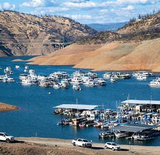 OROVILLE RECREATION Four paved boat ramps at Lime Saddle, Bidwell Canyon, Spillway, and Loafer Point are open at Lake Oroville, along with the Lime Saddle and Bidwell Canyon marinas, and reservations for campgrounds in the Lake Oroville State Recreation Area (LOSRA) can be made by visiting the California Department of Parks and Recreation (CA Parks) LOSRA website. Restrooms, potable water, and fish cleaning stations are not in service at the Spillway Boat Ramp area, but portable toilets are provided – please plan visits accordingly. A water and sewer pipeline replacement project is underway to restore these utilities. Please be aware of construction traffic in the vicinity of the Spillway Day Use Area. The Thermalito Forebay and Afterbay provide a wide range of recreation opportunities including fishing, hiking, biking and boating. Non-motorized boating is permitted in the North Forebay, and motorized boating is only permitted in the South Forebay and Afterbay. Boaters are reminded to abide by speed limits near boat launch areas and north of the Highway 162 bridge where Afterbay speed limits are five (5) miles per hour. Visitors are reminded to abide by all posted signage regarding permitted swimming areas (never near boating docks) to ensure public safety for all. Swimming near boat docks is dangerous – risks include propeller strikes and boat collisions, carbon monoxide poisoning from boat exhaust, electrical shock from shorted wiring in boats or docks, and an increased chance of polluted waters where boats are launched and retrieved. The North Forebay Aquatic Center has kayaks, paddle boards, and other watercraft available for rent Thursday through Sunday. Non-motorized boating is also permitted in the Thermalito Diversion Pool with kayak access just before the restroom on Cherokee Road. Lake Oroville and the Oroville Wildlife Area also have car-top boat launch areas. Visit the interactive map of recreation facilities in DWR’s Oroville-Thermalito Complex on DWR’s Lake Oroville Recreation webpage. And step inside the Lake Oroville Visitor Center, open Tuesday through Thursday from 9 a.m. to 5 p.m., to learn about the State Water Project and history of the area. 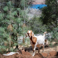 GRAZING GOATS REDUCE FIRE RISK Four hundred goats and sheep just completed the 50-acre grazing operation around Hyatt Powerplant and Canyon Drive towards Oroville Dam’s Upper Overlook. The goal of this project is to minimize the rate of spread of a potential fire by reducing ground fuels, ladder fuels (vegetation that reaches up from the ground into trees), and overgrown vegetation. Grazing is gaining popularity across California as a sustainable method to minimize wildfire risk and lessen the spread of a wildfire through vegetation management. The goats and sheep graze on grasses, leaves, poison oak, and a variety of shrubs and trees. By standing on their hind legs, they can reduce ladder fuels up to six feet high. Plus, they love to eat weeds, especially invasive ones. The goat grazing project is part of DWR’s Fuel Load Management Plan, which helps reduce wildfire risk, increase public safety, and enhance forest health in areas around Lake Oroville within the Federal Energy Regulatory Commission (FERC) project boundary. In partnership with Butte County Fire Safe Council, DWR continues to use grazing as a sustainable method of fuel reduction around DWR’s Oroville-Thermalito Complex. To learn more and to see goat grazing in action, visit DWR’s YouTube Channel for a video of the March 2021 Lakeland Boulevard goat grazing project on DWR’s YouTube webpage. 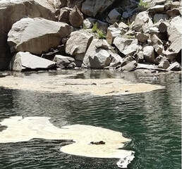 BLUE GREEN ALGAE MONITORING DWR environmental scientists regularly monitor for blue-green algae and their toxins during the summer months. There are currently no harmful algal bloom (HAB) advisories for Lake Oroville, the Thermalito Forebay, or the Thermalito Afterbay. Water samples are taken at various locations regularly from Memorial Day through Labor Day. To learn more about HABs, or to report a HAB visit the Water Board’s website. CURRENT LAKE OPERATIONS The elevation of Oroville’s reservoir is about 739 feet elevation and storage is about 1.58 million acre-feet (MAF), which is 45 percent of its total capacity and 63 percent of historical average. Very warm temperatures are anticipated over the weekend and into next week. Expect to see temperatures over 100 degrees throughout the week. The Feather River releases were increased last week and are currently at 4,000 cubic feet per second (cfs) to meet downstream Delta water quality and outflow needs. Flows through the City of Oroville are at planned at 1,550 cfs with 2,450 cfs released from the Thermalito Afterbay Outlet (Outlet) for a total of 4,000 cfs downstream of the Outlet. Flows through the low flow channel may fluctuate through the week for fisheries purposes. The public can track precipitation, snow, reservoir levels, and more at the California Data Exchange Center at www.cdec.water.ca.gov. The Lake Oroville gage station is identified as “ORO”. All data as of midnight 7/14/2022  California is entering its third year of drought conditions. With water conservation now a way of life in California, everyone is encouraged to find ways to save water. See tips, tools, and ideas on the Save Our Water website. Information about real time local hydrological conditions, forecasts, and water conditions is available on DWR’s new website California Water Watch.
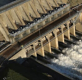 July 8, 2022 Oroville Radial Gates Project On July 12 the Department of Water Resources (DWR) and contractor staff will begin a multi-year project to perform maintenance repairs on the eight radial gate hoist assemblies of Oroville Dam’s Flood Control Outlet (FCO), or main spillway, as part of the Oroville Radial Gates Maintenance Repair Project. This project was established after the 2017 Oroville Spillway emergency to maintain the safe and reliable operation of the FCO, Thermalito Diversion Dam, and Thermalito Power Canal radial gates. In order to perform maintenance repairs on the existing eight radial gate hoist assemblies at the Oroville Dam FCO to address routine wear, the contractor Unico will perform an as-found site inspection of radial gate hoist assembly number eight to obtain dimensional and operational data that will be used to finalize the maintenance repair plan and to reverse-engineer the hoist assembly design for the fabrication of a replica hoist assembly. The spare radial gate hoist assembly (gear motor, wire ropes, gears and pinons, etc.) will be installed while an existing hoist is removed for inspection and maintenance to address any deficiencies due to wear, age, and serviceability of the equipment. Occurring yearly beginning in 2023, maintenance repairs will be performed on one gate hoist assembly per year during the dry season (May 1 and October 31), to ensure that all eight existing radial gate hoist assemblies are available and fully operational throughout flood season. Visitors to Oroville Dam and the Spillway Day Use/Boat Launch Area are advised to be aware of increased activity and construction equipment on Lakeside Access Road and around the top of the FCO gates the week of July 11. 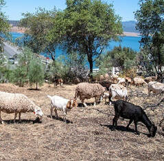 GRAZING GOATS REDUCE FIRE RISK Four hundred goats and sheep just completed the 50-acre grazing operation around Hyatt Powerplant and Canyon Drive towards Oroville Dam’s Upper Overlook. The goal of this project is to minimize the rate of spread of a potential fire by reducing ground fuels, ladder fuels (vegetation that reaches up from the ground into trees), and overgrown vegetation. Grazing is gaining popularity across California as a sustainable method to minimize wildfire risk and lessen the spread of a wildfire through vegetation management. The goats and sheep graze on grasses, leaves, poison oak, and a variety of shrubs and trees. By standing on their hind legs, they can reduce ladder fuels up to six feet high. Plus, they love to eat weeds, especially invasive ones. The goat grazing project is part of DWR’s Fuel Load Management Plan, which helps reduce wildfire risk, increase public safety, and enhance forest health in areas around Lake Oroville within the Federal Energy Regulatory Commission (FERC) project boundary. In partnership with Butte County Fire Safe Council, DWR continues to use grazing as a sustainable method of fuel reduction around DWR’s Oroville-Thermalito Complex. To learn more and to see goat grazing in action, visit DWR’s YouTube Channel for a video of the March 2021 Lakeland Boulevard goat grazing project on DWR’s YouTube webpage. 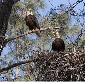 AMERICAN ICON INCREASES IN OROVILLE DWR environmental scientists have discovered a new bald eagle nesting territory at Lake Oroville, bringing the total number of nesting pairs who call this area home to eight. All but one of the eight nesting pairs who live around the lake and the Feather River are raising chicks, called ‘eaglets’. This year DWR’s scientists have been eagerly watching the development of ten eaglets – an increase from the nine spotted in 2021. The chicks have been spotted around Lake Oroville and in the Oroville Wildlife Area near the Feather River. Chicks typically fledge – grow flight feathers and become strong enough to attempt flying – during the months of June and July. Lake Oroville and the Feather River area provide ideal habitat for bald eagles, a species with both state and federal protections. Fish are one of the eagles' main food sources and large water bodies like Lake Oroville provide a wide variety of fish as well as other favorite food sources such as waterfowl, small birds, and mammals. The many trees and snags (tall dead trees) near water areas provide prime nesting and hunting locations for the resident pairs. When DWR’s first bald eagle surveys were conducted in 2002, three nesting territories were identified for protection. Currently, DWR has management plans and implements protections for all eight territories to help protect America’s national bird.  DWR AND CDFW RELEASE SALMON The Feather River Fish Hatchery in Oroville is one of the most productive and successful fish hatcheries on the West Coast of the United States. Millions of fish are raised every year including Chinook fall and spring run salmon and salmon’s cousin, steelhead trout. During February, over 500,000 steelhead smolts were released to the Feather River and between March and June this year, the hatchery released over 11.3 million young Chinook salmon smolts (juvenile fish) into the waters of the Feather River, San Pablo Bay, and San Francisco Bay. The smolts were loaded onto specialized trucks and transported to their various release locations. Transportation to the Bays, especially in drought conditions such as this year, improves survival by avoiding predators and numerous other obstacles and dangers in the Feather River, Sacramento River, and Delta. From these release locations, the smolts will make their way out to the Pacific Ocean where they will feed and grow for two to five years, supporting California’s commercial and sport fishery, before instinctively returning back to the Feather River to spawn and complete their life cycle. Read more about this annual release on the DWR Updates webpage. The Feather River Fish Hatchery is a California State Water Project (SWP) facility built in the late 1960s to mitigate fish migration impacts resulting from the construction of Oroville Dam. DWR maintains the facility and funds the hatchery operations, fish spawning, rearing, and stocking activities provided by California Department of Fish and Wildlife staff.  OROVILLE RECREATION The Lake Oroville State Recreation Area (LOSRA) is open for boating, camping, hiking, biking, horseback riding, and much more. The four main paved boat ramps at Lime Saddle, Bidwell Canyon, Spillway, and Loafer Point are open, along with the Lime Saddle and Bidwell Canyon marinas, and campground reservations can be made by visiting the California Department of Parks and Recreation (CA Parks) LOSRA website. Restrooms, potable water, and fish cleaning stations are not in service at the Spillway Boat Ramp area but portable toilets are provided – please plan visits accordingly. A water and sewer pipeline replacement project will break ground this week to restore these utilities. Please be aware of construction traffic in the vicinity of the Spillway Day Use Area. Visitors to the Thermalito North Forebay will find a full CA Parks facility with restrooms, picnic areas, a swim beach, and the Forebay Aquatic Center with kayaks, paddle boards, and other watercraft available for rent Thursday through Sunday. The Monument Hill facility at the Thermalito Afterbay also provides boat ramp access, restrooms, a picnic area, and a swim beach. The 11,000 acres of prime wildlife viewing in the Oroville Wildlife Area also contains the Clay Pit State Vehicular Recreation area for Off-Highway Vehicles (OHVs) (south of Oroville Airport). The OWA is administered for DWR by California Department of Fish and Wildlife (CDFW) and information about the Oroville Wildlife Area is available on the CDFW webpage. The Lake Oroville Visitor Center is open Tuesday through Thursday from 9 a.m. to 5 p.m. An interactive map of recreation facilities in DWR’s Oroville-Thermalito Complex is available on DWR’s Lake Oroville Recreation webpage. Visitors are encouraged to be fire smart, bring plenty of sunscreen, stay hydrated, avoid leaving valuables in visible areas, be prepared for cold water temperatures, and be mindful of personal safety and the safety of those around you.  BLUE GREEN ALGAE MONITORING DWR environmental scientists regularly monitor for blue-green algae and their toxins during the summer months. There are currently no harmful algal bloom (HAB) advisories for Lake Oroville, the Thermalito Forebay, or the Thermalito Afterbay. Water samples are taken at various locations regularly from Memorial Day through Labor Day. To learn more about HABs, or to report a HAB visit the Water Board’s website. CURRENT LAKE OPERATIONS The elevation of Oroville’s reservoir is about 747 feet elevation and storage is about 1.65 million acre-feet (MAF), which is 47 percent of its total capacity and 63 percent of historical average. Temperatures over the weekend are projected to be in the mid-90s and increasing to the low-100s next week. The Feather River releases were increased last week and are currently at 4,500 cubic feet per second (cfs) to meet downstream Delta water quality and outflow needs. Flows through the City of Oroville are at planned at 1,050 cfs with 3,450 cfs released from the Thermalito Afterbay Outlet (Outlet) for a total of 4,500 cfs downstream of the Outlet. Flows through the low flow channel may fluctuate through the week for fisheries purposes. The public can track precipitation, snow, reservoir levels, and more at the California Data Exchange Center at www.cdec.water.ca.gov. The Lake Oroville gage station is identified as “ORO”. All data as of midnight 7/7/2022  California is entering its third year of drought conditions. With water conservation now a way of life in California, everyone is encouraged to find ways to save water. See tips, tools, and ideas on the Save Our Water website. Information about real time local hydrological conditions, forecasts, and water conditions is available on DWR’s new website California Water Watch.
 June 24, 2022 Apprentice Opportunities The Department of Water Resources (DWR) paid apprenticeship program exams will be available June 24 to June 30 for those interested in applying for electrician, operator, mechanic, or utility craftsworker positions in California’s hydroelectric industry. Most apprenticeship positions have education requirements of equivalent to graduation from high school and knowledge of basic arithmetic and algebra, electrical fundamentals, and mechanical principles. The online exams are currently posted on DWR’s CalCareers webpage with links to the individual exams for Hydroelectric Plant (HEP) Electrician Apprentice, HEP Mechanic Apprentice, HEP Operator Apprentice, and Utility Craftsworker Apprentice. Applying for more than one apprenticeship position is permitted but interested persons are reminded the online exams will only be available Friday, June 24 through Thursday, June 30. Passing applicants will be ranked and those with scores higher than 70 will be placed on the position’s eligible for hire list and can then apply for the apprenticeship program’s position openings. More information is available on the DWR Updates webpage. DWR has eight hydroelectric powerplants in the State Water Project, three of which are in the Oroville-Thermalito Complex – Edward Hyatt Powerplant, Thermalito Diversion Dam Powerplant, and Ronald B. Robie Thermalito Pumping-Generating Plant. 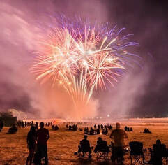 FOURTH OF JULY FIREWORKS The City of Oroville’s Noon Rotary Club fireworks will begin at approximately 9 p.m. on July Fourth and will be launched from the Oroville Airport. A Red Flag (severe fire danger) Warning from the National Weather Service for July Fourth will cancel the display. The morning at the airport will be filled with an airplane “fly-in”, pancake breakfast, car show, and airplane rides. Viewers are encouraged to observe the fireworks show from their homes, if possible, or higher locations throughout the City of Oroville and surrounding area. The Clay Pit State Vehicular Recreation Area will close at sunset on Sunday, July 3 and remain closed until 8 a.m. Tuesday, July 5. The Nelson Avenue Sports Complex will be open but the pool will be closed. The Oroville Wildlife Area and Thermalito Afterbay will also maintain normal operating hours on July Fourth: 1.5 hours before sunrise to one hour after sunset. Information on morning activities at the airport, suggested viewing locations for the fireworks, and other event information is available on the Oroville Area Chamber of Commerce website. 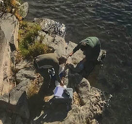 WATER QUALITY WORKING GROUP In November and December 2020, a multi-agency task force comprised of the State Water Resources Control Board and Central Valley Regional Water Quality Control Board; Butte County Department of Public Works; California Department of Water Resources; California Department of Fish and Wildlife; California Department of Parks and Recreation; and Governor’s Office of Emergency Services came together as the ‘Watershed Working Group’ to address water quality concerns in the North Complex Wildfire burn area and downstream. In 2021, the burn area of the Dixie Wildfire was added for monitoring, and additional partner agencies were added to the working group. Widespread testing of surface waters throughout these burn scars in Butte and Plumas counties has been completed. Sampling results over the winter of 2021-22 revealed that while contaminant levels were slightly elevated in some instances, they did not exceed primary drinking water contaminant thresholds, and did not adversely impact drinking water treatment facilities or the quality of drinking water they deliver to their communities. The working group’s agencies will now transition to routine water quality monitoring, which includes monitoring for issues such as Harmful Algal Blooms. Building on the success of the collaboration, this working group will continue to meet to discuss watershed health and be ready for the upcoming fire season. The public is reminded to always treat surface waters before drinking or cooking when recreating outdoors. Homeowners with wells in burn scar areas should review their well construction and consider contacting their county Environmental Health Division for information about testing well water.  BLUE GREEN ALGAE MONITORING The Department of Water Resources (DWR) environmental scientists regularly monitor for blue-green algae and their toxins during the summer months. There are currently no harmful algal bloom (HAB) advisories for Lake Oroville, Upper Feather River lakes, the Thermalito Forebay, or the Thermalito Afterbay. Water samples are taken at various locations regularly from Memorial Day through Labor Day and sent to a lab for toxin analysis. Blue-green algae (cyanobacteria) is a natural component of ecosystems. Under certain conditions, including warmer temperatures and increased nutrient loads, algae can grow rapidly causing “blooms.” Algal blooms sometimes produce toxins that can be harmful to people and animals. Algal blooms can make the water appear green, blue, or brown in color. Seeing colors, mats, foam, scum, or paint-like streaks in the water may indicate a bloom is present. Keep animals and children away from the water when a suspected HAB is present and report the possible HAB immediately. If elevated levels of cyanobacteria toxins are found while testing, DWR staff will work with California’s Regional Water Quality Control Board and recreation area managers to notify the public and post advisory signs at affected waterbodies. To learn more about HABs, or to report a HAB visit the Water Board’s website.  OROVILLE RECREATION The Lake Oroville State Recreation Area (LOSRA) is open for boating, camping, hiking, biking, horseback riding, and much more. The four main paved boat ramps at Lime Saddle, Bidwell Canyon, Spillway, and Loafer Point are open, along with the Lime Saddle and Bidwell Canyon marinas, and campground reservations can be made by visiting the CA Parks LOSRA website. Restrooms, potable water, and fish cleaning stations are not in service at the Spillway Boat Ramp area but portable toilets are provided – please plan visits accordingly. The Thermalito Forebays and Afterbay also provide a wide range of water recreation opportunities along with hiking trails, the Clay Pit State Vehicular Recreation area for Off-Highway Vehicles (OHVs) (south of Oroville Airport), and the 11,000 acres of prime wildlife viewing in the Oroville Wildlife Area. The OWA is administered for DWR by the CDFW and information about the 11,000-acre Oroville Wildlife Area is available on the CDFW webpage. The Forebay Aquatic Center in the North Forebay Recreation Area is open 10 a.m. to 8 p.m. Friday to Sunday with kayaks, paddle boards, and other watercraft available for rent. The Lake Oroville Visitor Center is open Tuesday through Thursday from 9 a.m. to 5 p.m. An interactive map of recreation facilities in DWR’s Oroville-Thermalito Complex is available on DWR’s Lake Oroville Recreation webpage. Visitors are encouraged to be fire smart, bring plenty of sunscreen, stay hydrated, avoid leaving valuables in visible areas, be prepared for cold water temperatures, and be mindful of personal safety and the safety of those around you. CURRENT LAKE OPERATIONS The elevation of Oroville’s reservoir is about 761 feet elevation and storage is about 1.78 million acre-feet (MAF), which is 50 percent of its total capacity and 66 percent of historical average. Extreme heat above 100 degrees is expected to continue through the weekend and temperatures are forecasted to drop to the upper 90s next week. The Feather River releases were increased last week and are currently at 3,500 cubic feet per second (cfs) to meet downstream Delta water quality and outflow needs. Currently, flows down the low flow channel will be ramping down beginning on Saturday and by Monday, flows through the City of Oroville are planned to be at 650 cfs with 2,850 cfs released from the Thermalito Afterbay Outlet (Outlet) for a total of 3,500 cfs downstream of the Outlet. The public can track precipitation, snow, reservoir levels, and more at the California Data Exchange Center at www.cdec.water.ca.gov. The Lake Oroville gage station is identified as “ORO”. All data as of midnight 6/23/2022  California is entering its third year of drought conditions. With water conservation now a way of life in California, everyone is encouraged to find ways to save water. See tips, tools, and ideas on the Save Our Water website. Information about real time local hydrological conditions, forecasts, and water conditions is available on DWR’s new website California Water Watch.
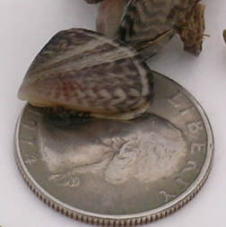 June 10, 2022 Protecting Against Quagga and Zebra Mussels As boating season kicks off, The Department of Water Resources (DWR), California State Parks’ Division of Boating and Waterways (DBW), and California Department of Fish and Wildlife (CDFW) urge boaters to always remember to clean, drain, and dry their boats before entering and leaving lakes, rivers, and other waterways to help prevent the spread of quagga or zebra mussels. These two non-native freshwater mollusks – quagga and zebra mussels – pose a serious threat to California’s aquatic ecosystems. Quagga and zebra mussels are small, invasive species that colonize on hard surfaces, such as boat hulls and pontoons, docks and pilings, rocks, concrete, plastics, and even discarded bottles and cans. DWR’s Oroville Field Division biologists regularly sample Lake Oroville -for indicators the mollusks are present and, to date, none have been found. Quagga and zebra mussels can be spread to new waterbodies when attached to boats as adults, or as microscopic juveniles in water in motors, bilges, and livewells. They are smaller than a dime, and juvenile mussels may even be difficult to detect with the naked eye. Despite their small size, they can cause major damage to water delivery systems, hydroelectric facilities, and watercraft engines. When boating, make it a habit to do the following:
SOUTH FOREBAY CLOSED The California Department of Parks and Recreation (CA Parks) announced today the South Forebay and the Nelson Bridge Day Use Area will be closed from 8 a.m. Saturday, June 11 to 8 a.m. Monday, June 13 for a private boat racing event. Entrances to the South Forebay at Grand Avenue, Nelson Avenue Bridge Day Use Area and behind Poplar Avenue Elementary School will be closed, including the levee system to the east and south of the forebay. CA Parks has closed these areas to public use, entry, or occupancy.  CAL FIRE CONTROL BURNS In cooperation with DWR and CA Parks, CAL FIRE conducted control burns around the North Forebay, the Nelson Sports Complex, and along Grand Avenue this past week. The vegetation management-control burns have multiple beneficial impacts for the natural environment and public safety. Around the Thermalito Forebay are many seasonal wetlands called vernal pools which support a high diversity of California native plants and animals, including rare and endangered species and species endemic to California (i.e., found nowhere else in the world). Fire from carefully controlled burns is the most powerful tool to combat invasive plants and dry invasive grass buildup called ‘thatch’ within these grasslands and vernal pools, as well as from grassland adjacent to private property and near high-use areas. Additional plots may be burned over the next two weeks at Loafer Creek Recreation Area as weather conditions allow. Smoke will be visible at times in the Kelly Ridge and Greater Oroville areas throughout the duration of the project. 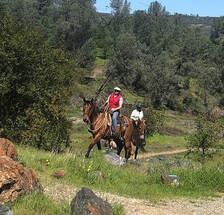 OROVILLE RECREATION The Lake Oroville State Recreation Area (LOSRA) is open for boating, camping, hiking, biking, horseback riding, and much more. The four main paved boat ramps at Lime Saddle, Bidwell Canyon, Spillway, and Loafer Point are open, along with the Lime Saddle and Bidwell Canyon marinas, and campground reservations can be made by visiting the CA Parks LOSRA website. Restrooms, potable water, and fish cleaning stations are not in service at the Spillway Boat Ramp area but portable toilets are provided – please plan visits accordingly. The Thermalito Forebays and Afterbay also provide a wide range of water recreation opportunities along with hiking trails, the Clay Pit State Vehicular Recreation area for Off-Highway Vehicles (OHVs) (south of Oroville Airport), and the 11,000 acres of prime wildlife viewing in the Oroville Wildlife Area. The OWA is administered for DWR by the CDFW and information about the 11,000-acre Oroville Wildlife Area is available on the CDFW webpage. The Forebay Aquatic Center in the North Forebay Recreation Area is open 10 a.m. to 8 p.m. Friday to Sunday with kayaks, paddle boards, and other watercraft available for rent. An interactive map of recreation facilities in DWR’s Oroville-Thermalito Complex is available on DWR’s Lake Oroville Recreation webpage. Visitors are encouraged to be fire smart, bring plenty of sunscreen, stay hydrated, avoid leaving valuables in visible areas, be prepared for cold water temperatures, and be mindful of personal safety and the safety of those around you. 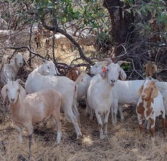 GRAZING EFFORTS REDUCE FIRE RISK More than 100 goats and sheep continue to provide vegetation management along Canyon Drive from Royal Oaks Drive to Oroville Dam’s Upper Overlook Parking Area as part of DWR’s Fuel Load Management Plan to reduce wildfire risk, increase public safety, and enhance forest health in areas around Lake Oroville. To increase the amount of vegetation removed, a mixture of goats and sheep are used by contractor Hanski Family Farms because the animals prefer different vegetation types. Goats prefer ladder fuels (shrubs, bushes, smaller trees, or tree branches near the ground) and sheep prefer grasses. When goats stand on their hind legs, they can reduce ladder fuels up to six feet high. DWR, in partnership with Butte County Fire Safe Council, continues to use grazing as a sustainable method of fuel reduction around DWR’s Oroville-Thermalito Complex, including Lake Oroville. CURRENT LAKE OPERATIONS The elevation of Oroville’s reservoir is about 770 feet elevation and storage is about 1.87 million acre-feet (MAF), which is 53 percent of its total capacity and 68 percent of historical average. The forecast calls for a chance of rain over the weekend with dry conditions next week. Temperatures are forecasted to be in the low-100s on Saturday and will be dropping beginning on Sunday into next week. Temperatures are expected to fluctuate from the low-80s-to-mid-90s through the week. The Feather River releases were increased last week and are currently at 3,500 cubic feet per second (cfs) to meet downstream Delta water quality and outflow needs. Currently, flows down the low flow channel through the City of Oroville have increased to 1,450 cfs and 2,050 cfs is being released from the Thermalito Afterbay Outlet (Outlet) for a total of 3,500 cfs downstream of the Outlet. Flows are assessed daily and may fluctuate through the low flow channel for fisheries purposes during the week. The public can track precipitation, snow, reservoir levels, and more at the California Data Exchange Center at www.cdec.water.ca.gov. The Lake Oroville gage station is identified as “ORO”. All data as of midnight 6/9/2022  California is entering its third year of drought conditions. With water conservation now a way of life in California, everyone is encouraged to find ways to save water. See tips, tools, and ideas on the Save Our Water website. Information about real time local hydrological conditions, forecasts, and water conditions is available on DWR’s new website California Water Watch.
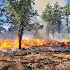 May 27, 2022 CAL FIRE Control Burns In cooperation with the Department of Water Resources (DWR) and California Department of Parks and Recreation (CA Parks), CAL FIRE conducted control burns of around 185 acres this past week at South Forebay near Grand Avenue (~65 acres), near Wilbur Road and Tres Vias Road (~120 acres), and at the Loafer Creek Recreation Area (~55 acres). The vegetation management-control burns have multiple beneficial impacts for the natural environment and public safety. Around the Thermalito Forebay are many seasonal wetlands called vernal pools which support a high diversity of California native plants and animals, including rare and endangered species and species endemic to California (i.e., found nowhere else in the world). Fire from carefully controlled burns is the most powerful tool to combat invasive plants and dry invasive grass buildup called ‘thatch’ within these grasslands and vernal pools, as well as from grassland adjacent to private property and near high-use areas. The control burn at Loafer Creek Recreation Area removed fuels such as brush and dry grasses from several plots totaling around 55 acres. Prescribed fires, when conducted on a regular basis, help to reduce the risk of catastrophic wildfires on area landscapes and surrounding communities by reducing the amount of fire hazardous vegetation. Previous CAL FIRE prescribed fires, and vegetation management reduction work in the Loafer Creek area done through DWR’s Fuel Load Management Program, as credited with slowing the North Complex Fire in 2020 enough for firefighters to gain the upper hand, establish a successful fire line, and prevent further forward progression of the fire. Additional plots may be burned over the next two weeks at Loafer Creek as weather conditions allow. Smoke will be visible at times in the Kelly Ridge and Greater Oroville areas throughout the duration of the project.  OROVILLE RECREATION With Memorial Day – the unofficial start of summer – just behind us, DWR invites the public to take advantage of the many recreation opportunities at the State Water Project’s Oroville Thermalito Complex. Lake Oroville: The Spillway, Loafer Point, Bidwell Canyon, and Lime Saddle boat ramps are open 24-hours, seven days a week and car-top boat ramps are open from 8 a.m. to sunset. Both the Lime Saddle and Bidwell Canyon Marinas are open and provide boat rentals. Restrooms, potable water, and fish cleaning stations are not in service at the Spillway Boat Ramp area but portable toilets are provided – please plan visits accordingly. Thermalito Forebays and Afterbay: Visitors to the Thermalito North Forebay will find a full California Department of Parks and Recreation (CA Parks) facility with restrooms, picnic areas, a swim beach, and the Forebay Aquatic Center with kayaks, paddle boards, and other watercraft available for rent. Power boating is not allowed on the North Forebay but is permitted on the Thermalito South Forebay where the boat ramp area has a sandy beach, picnic tables, shade trees and vault toilets (no drinking water is available). The Monument Hill and Wilbur Road boat ramp areas on the Thermalito Afterbay are open as well as the Larkin Road car-top boat ramp. The Monument Hill facility provides boat ramp access, restrooms, a picnic area, and a swim beach. The Wilbur Road boat ramp has boat launch lanes and a vault toilet. Boaters on the Afterbay are reminded of the 5-mph speed limit north of the Highway 162 bridge and that access to the Afterbay is from 1.5 hours before sunrise to one hour after sunset. Oroville Wildlife Area: Primarily a primitive wildlife area managed for fishing, wildlife viewing and hunting, the Oroville Wildlife Area (OWA) is accessed primarily by boat on the Feather River, by area trails, or from developed and primitive roads off Highway 162, Highway 70, and Larkin Road. The Clay Pit State Vehicular Recreation area for Off-Highway Vehicles (OHVs), a CA Parks facility, is located south of the Oroville Airport and the clay used to build the core of Oroville Dam was excavated from this area. The OWA is administered for DWR by the California Department of Fish and Wildlife (CDFW) and information about the 11,000-acre Oroville Wildlife Area is available on the CDFW webpage. Lake Oroville Visitor Center and Area Trails: The Visitor Center is open to the public on Tuesdays, Wednesdays, and Thursdays from 9 a.m. to 5 p.m. where visitors can view educational exhibits, walk area trails, and climb the 47-foot-tall viewing tower. The Lake Oroville Trails Map, which shows more than 91 miles of trails available to equestrians, bicyclists, and hikers all around the facilities mentioned above, is available at the Visitor Center, at Lake Oroville State Recreation Area (LOSRA) kiosks, the Oroville Area Chamber of Commerce, or at the Feather River Recreation and Parks office. An interactive map of recreation facilities in DWR’s Oroville-Thermalito Complex is available on DWR’s Lake Oroville Recreation webpage at https://water.ca.gov/What-We-Do/Recreation/Lake-Oroville-Recreation. Visitors are encouraged to be fire smart, bring plenty of sunscreen, stay hydrated, avoid leaving valuables in visible areas, and be mindful of personal safety and the safety of those around you. 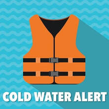 COLD WEATHER ALERT With the Memorial Day holiday and warm weather starting the summer months, DWR reminds those recreating in area lakes and rivers that waters are still very cold. The Feather River below Oroville Dam is around 55 to 60 degrees. While surface temperatures of Lake Oroville can be warmer, colder water is present only a few feet below the surface. Additionally, inflows from snowmelt are feeding the upper reaches of the Feather River’s forks where cold water shock can impair breathing and heart rate after a sudden immersion. Outdoor enthusiasts are encouraged to be mindful of water temperatures and wear a life jacket if near or on the water. For more information, visit the National Weather Service’s Safety webpage. PLUMAS NATIONAL FOREST Several recreation sites on the Plumas National Forest have opened, including on DWR’s Upper Feather Lakes of Lake Davis, Frenchman Lake, and Antelope Lake. Recreation facilities such as day use areas, beaches, and campgrounds, are managed by the U.S. Forest Service and their contractors. For information about recreation facility locations, amenities, and current conditions and restrictions, visit the Plumas National Forest webpage. 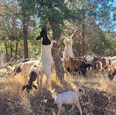 GRAZING EFFORTS REDUCE FIRE RISK Drivers along Canyon Drive from Royal Oaks Drive to Oroville Dam’s Upper Overlook Parking Area will see how grazing is used in DWR’s Fuel Load Management Plan to reduce wildfire risk, increase public safety, and enhance forest health in areas around Lake Oroville. For the next couple of weeks, goats and sheep will be visible along the hillside adjacent to the roadway. To increase the amount of vegetation removed, a mixture of goats and sheep are used by contractor Hanski Family Farms because the animals prefer different vegetation types. Goats prefer ladder fuels (shrubs, bushes, smaller trees, or tree branches near the ground) and sheep prefer grasses. When goats stand on their hind legs, they can reduce ladder fuels up to six feet high. DWR, in partnership with Butte County Fire Safe Council, continues to use grazing as a sustainable method of fuel reduction around DWR’s Oroville-Thermalito Complex, including Lake Oroville. To learn more, visit DWRs YouTube Channel for a video of the March 2021 Lakeland Boulevard goat grazing project. CURRENT LAKE OPERATIONS The elevation of Oroville’s reservoir is about 772 feet elevation and storage is about 1.9 million acre-feet (MAF), which is 54 percent of its total capacity and 68 percent of historical average. The forecast calls for a chance of rain over the weekend with dry conditions next week. Temperatures are expected to be in the mid-to-upper-70s over the weekend and increasing to the mid-90s by the middle of the week. The Feather River releases were increased last week and are currently at 3,000 cubic feet per second (cfs) to meet downstream Delta water quality and outflow needs. Flow in the low-flow channel through the City of Oroville is 650 cfs and flow through the Thermalito Afterbay Outlet is currently 2,350 cfs. Flows are assessed daily. The public can track precipitation, snow, reservoir levels, and more at the California Data Exchange Center at www.cdec.water.ca.gov. The Lake Oroville gage station is identified as “ORO”. All data as of midnight 6/2/2022  California is entering its third year of drought conditions. With water conservation now a way of life in California, everyone is encouraged to find ways to save water. See tips, tools, and ideas on the Save Our Water website. Information about real time local hydrological conditions, forecasts, and water conditions is available on DWR’s new website California Water Watch.
 May 27, 2022 Oroville Recreation With Memorial Day – the unofficial start of summer – upon us, the Department of Water Resources (DWR) invites the public to take advantage of the many recreation opportunities at the State Water Project’s Oroville Thermalito Complex. Lake Oroville: The Spillway, Loafer Point, Bidwell Canyon, and Lime Saddle boat ramps are open 24-hours, seven days a week and car-top boat ramps are open from 8 a.m. to sunset. Both the Lime Saddle and Bidwell Canyon Marinas are open and provide boat rentals. Restrooms, potable water, and fish cleaning stations are not in service at the Spillway Boat Ramp area but portable toilets are provided – please plan visits accordingly. Thermalito Forebays and Afterbay: Visitors to the Thermalito North Forebay will find a full California Department of Parks and Recreation (CA Parks) facility with restrooms, picnic areas, a swim beach, and the Forebay Aquatic Center with kayaks, paddle boards, and other watercraft available for rent. Power boating is not allowed on the North Forebay but is permitted on the Thermalito South Forebay where the boat ramp area has a sandy beach, picnic tables, shade trees and vault toilets (no drinking water is available). The Monument Hill and Wilbur Road boat ramp areas on the Thermalito Afterbay are open as well as the Larkin Road car-top boat ramp. The Monument Hill facility provides boat ramp access, restrooms, a picnic area, and a swim beach. The Wilbur Road boat ramp has boat launch lanes and a vault toilet. Boaters on the Afterbay are reminded of the 5-mph speed limit north of the Highway 162 bridge and that access to the Afterbay is from 1.5 hours before sunrise to one hour after sunset. Oroville Wildlife Area: Primarily a primitive wildlife area managed for fishing, wildlife viewing and hunting, the Oroville Wildlife Area (OWA) is accessed primarily by boat on the Feather River, by area trails, or from developed and primitive roads off Highway 162, Highway 70, and Larkin Road. The Clay Pit State Vehicular Recreation area for Off-Highway Vehicles (OHVs), a CA Parks facility, is located south of the Oroville Airport and the clay used to build the core of Oroville Dam was excavated from this area. The OWA is administered for DWR by the California Department of Fish and Wildlife (CDFW) and information about the 11,000-acre Oroville Wildlife Area is available on the CDFW webpage. Lake Oroville Visitor Center and Area Trails: The Visitor Center is open to the public on Tuesdays, Wednesdays, and Thursdays from 9 a.m. to 5 p.m. where visitors can view educational exhibits, walk area trails, and climb the 47-foot-tall viewing tower. The Lake Oroville Trails Map, which shows more than 91 miles of trails available to equestrians, bicyclists, and hikers all around the facilities mentioned above, is available at the Visitor Center, at Lake Oroville State Recreation Area (LOSRA) kiosks, the Oroville Area Chamber of Commerce, or at the Feather River Recreation and Parks office. An interactive map of recreation facilities in DWR’s Oroville-Thermalito Complex is available on DWR’s Lake Oroville Recreation webpage at https://water.ca.gov/What-We-Do/Recreation/Lake-Oroville-Recreation. Visitors are encouraged to be fire smart, bring plenty of sunscreen, stay hydrated, avoid leaving valuables in visible areas, and be mindful of personal safety and the safety of those around you. 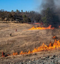 COLD WEATHER ALERT With the Memorial Day holiday and warm weather starting the summer months, DWR reminds those recreating in area lakes and rivers that waters are still very cold. The Feather River below Oroville Dam is around 55 to 60 degrees. While surface temperatures of Lake Oroville can be warmer, colder water is present only a few feet below the surface. Additionally, inflows from snowmelt are feeding the upper reaches of the Feather River’s forks where cold water shock can impair breathing and heart rate after a sudden immersion. Outdoor enthusiasts are encouraged to be mindful of water temperatures and wear a life jacket if near or on the water. For more information, visit the National Weather Service’s Safety webpage. PLUMAS NATIONAL FOREST Several recreation sites on the Plumas National Forest have opened, including on DWR’s Upper Feather Lakes of Lake Davis, Frenchman Lake, and Antelope Lake. Recreation facilities such as day use areas, beaches, and campgrounds, are managed by the U.S. Forest Service and their contractors. For information about recreation facility locations, amenities, and current conditions and restrictions, visit the Plumas National Forest webpage. 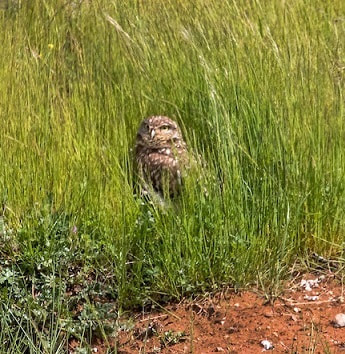 THERMALITO FOREBAY CONTROL BURNS A series of vegetation management burns around the Thermalito Forebay were conducted by CAL FIRE/Butte County Fire Department on May 27 in cooperation with the Department of Water Resources (DWR) and CA Parks. A total of about 60 acres near the Forebay Aquatic Center (~20 acres) and west of the Nelson Sports Complex (~40 acres) were successfully treated along with 30 acres of grassland at the Rabe Road Shooting Range south of Oroville Airport. An additional treatment of 185 acres is planned for the week of May 30 at South Forebay near Grand Avenue (~65 acres), and near Wilbur Road and Tres Vias Road (~120 acres). The vegetation management-controlled burns have multiple benefits for the natural environment and public safety. The grasslands around the Thermalito Forebay are home to many seasonal wetlands called vernal pools. Although vernal pools are only a small component of these grasslands, they support a high diversity of California native plants and animals, including rare and endangered species and species endemic to California (i.e., found nowhere else in the world). Fire from carefully controlled burns is the most powerful tool to combat invasive plants and dry invasive grass buildup called ‘thatch’ within these grasslands and vernal pools. Removal of invasive species allows native plants and animal species, such as fairy shrimp, to thrive. The burns will also remove dangerous fire fuels from grassland adjacent to private property and near high-use areas. CAL FIRE Battalion Chief Jason Dyer also noted that the projects allow firefighters to practice skills in a controlled environment.  GRAZING EFFORTS REDUCE FIRE RISK Drivers along Canyon Drive from Royal Oaks Drive to Oroville Dam’s Upper Overlook Parking Area will see how grazing is used in DWR’s Fuel Load Management Plan to reduce wildfire risk, increase public safety, and enhance forest health in areas around Lake Oroville. For the next couple of weeks, goats and sheep will be visible along the hillside adjacent to the roadway. To increase the amount of vegetation removed, a mixture of goats and sheep are used by contractor Hanski Family Farms because the animals prefer different vegetation types. Goats prefer ladder fuels (shrubs, bushes, smaller trees, or tree branches near the ground) and sheep prefer grasses. When goats stand on their hind legs, they can reduce ladder fuels up to six feet high. DWR, in partnership with Butte County Fire Safe Council, continues to use grazing as a sustainable method of fuel reduction around DWR’s Oroville-Thermalito Complex, including Lake Oroville. To learn more, visit DWRs YouTube Channel for a video of the March 2021 Lakeland Boulevard goat grazing project on DWR’s YouTube webpage. CURRENT LAKE OPERATIONS The elevation of Oroville’s reservoir is about 776 feet elevation and storage is about 1.9 million acre-feet (MAF), which is 54 percent of its total capacity and 69 percent of historical average. Expect dry and temperatures in the mid-70s to 80s this weekend, increasing to the low- to mid-90s next week. The Feather River releases were increased last week and are currently at 2,700 cubic feet per second (cfs) to meet downstream Delta water quality and outflow needs. Flow in the low-flow channel through the City of Oroville is 650 cfs and flow through the Thermalito Afterbay Outlet is currently 2,050 cfs. Flows are assessed daily. The public can track precipitation, snow, reservoir levels, and more at the California Data Exchange Center at www.cdec.water.ca.gov. The Lake Oroville gage station is identified as “ORO”. All data as of midnight 5/26/2022  California is entering its third year of drought conditions. With water conservation now a way of life in California, everyone is encouraged to find ways to save water. See tips, tools, and ideas on the Save Our Water website. Information about real time local hydrological conditions, forecasts, and water conditions is available on DWR’s new website California Water Watch.
 May 20, 2022 Inland Salmon Released into Lake Oroville California Department of Fish and Wildlife (CDFW) staff from the Feather River Fish Hatchery released 129,200 triploid fall-run “inland” Chinook fingerling salmon into Lake Oroville on May 12 at the Loafer Point Stage II Boat Ramp to support the recreational fishery. Of the 129,200 fish planted, 110,200 were direct release from the boat ramp and 19,000 fish were released into the main body of Lake Oroville from boats equipped with well holding tanks. This is the first year the fish were released into the main body of the lake to diversify and increase fishing opportunities. The inland Chinook measured about four to five inches in length and were raised at the Feather River Fish Hatchery. The fish are triploid, meaning unable to reproduce, which allows them to grow larger in size instead of putting energy into reproducing and it prevents any of these fish escaping Lake Oroville from hybridizing with sensitive downstream Chinook salmon populations. The Department of Water Resources (DWR) built, maintains, and funds the Feather River Fish Hatchery in partnership with CDFW staff who conduct fish spawning, rearing, and stocking activities at the hatchery. The Hatchery’s fish planting program has been in operation since 1968. A virtual tour of the Hatchery can be viewed on DWR’s YouTube channel and additional information can be found on the CDFW website. 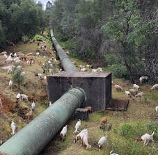 GRAZING EFFORTS REDUCE FIRE RISK Drivers traveling Oroville Dam Boulevard East below Oroville Dam have been treated to views of hundreds of goats and sheep grazing on nearly 35 acres along the Brad Freeman Trail, Hyatt Powerplant, and the Lower Overlook. Next week they will be moved to Canyon Drive where they will be grazing for the next couple of weeks along the hillside from Royal Oaks Drive to the Upper Overlook Parking Area. To increase the amount of vegetation removed, a mixture of goats and sheep are used by contractor Hanski Family Farms because the animals prefer different vegetation types. Goats prefer ladder fuels (shrubs, bushes, smaller trees, or tree branches near the ground) and sheep prefer grasses. When goats stand on their hind legs, they can reduce ladder fuels up to six feet high. The grazing project is part of DWR’s Fuel Load Management Plan, which helps reduce wildfire risk, increase public safety, and enhance forest health in areas around Lake Oroville. In partnership with Butte County Fire Safe Council, DWR continues to use grazing as a sustainable method of fuel reduction around DWR’s Oroville-Thermalito Complex, including Lake Oroville. To learn more and to see goat grazing in action, visit DWRs YouTube Channel for a video of the March 2021 Lakeland Boulevard goat grazing project on DWR’s YouTube webpage.  DROUGHT UPDATE Warming temperatures, along with the driest January through March on record, has left the statewide snowpack at 14 percent of average for this date despite the recent late season storms. The main benefit of late season storms will be to prevent soils from drying out early in the season, which can aid runoff efficiency of the remaining snowpack to the state’s reservoirs. Reservoir levels across California vary depending on their location and source of inflows but all are reflective of the state entering its third year of drought. Locally, record-setting precipitation from the late October 2021 atmospheric river (AR) storm fell mainly in the Feather River (Oroville Dam) and American River (Folsom Dam) watersheds, missing a large part of the Lake Shasta watershed. Lake Oroville currently has more storage than on this date last year and the Department of Water Resources (DWR) is working to preserve as much storage as possible for future needs to maintain Delta water quality, protect endangered species, and meet senior water right obligations. DWR is also administering a number of grant programs to help mitigate and address drought impacts. One program, the Small Community Drought Relief Program, has already awarded more than $33 million to local counties and cities around Oroville for projects such as water system improvements and connections in Orland, Berry Creek, and Williams and for water hauling in Butte, Glenn, and Colusa counties. The DWR hydrology team and a California Water Board data specialist held a media briefing with reporters and meteorologists May 10 to discuss the latest drought data points and where we stand in terms of current conditions. A recording of the briefing is available on the DWR YouTube webpage. As we enter the warmer months, everyone is encouraged to find ways to save water, because despite current reservoir levels, the state is going to have water challenges later this year. See tips, tools, and ideas on the Save Our Water website. Information about real time local hydrological conditions, forecasts, and water conditions is available on DWR’s new website California Water Watch. Visit DWR’s Drought webpage for the latest information.  OROVILLE RECREATION The Spillway Boat Ramp opened on April 29, joining the open Loafer Point, Bidwell Canyon, and Lime Saddle boat ramps. The Foreman Creek and Stringtown cartop boat ramps are also open. Restrooms, potable water, and fish cleaning stations are not in service at the Spillway Boat Ramp area but portable toilets are provided – please plan visits accordingly. Information on current boat ramp status can be found on the California State Parks’ Lake Oroville State Recreation Area webpage. Scroll down to the link for “Current Launch Ramp Status”. Visitors to Oroville Dam and the Spillway Boat Ramp area will be able to use the newly constructed Lakeside Access Road which descends into the lake inundation zone before travelling back up to the Spillway Boat Ramp parking lot where they can access boat launch lanes, a shaded day use area with picnic tables, and multi-use trails suitable for hikers, bikers, and equestrians. The previous access road through the CHP screening booths and below the Emergency Spillway will only need to be used when lake elevations rise high enough to flood the new Lakeside Access Road. The Lake Oroville Visitor Center is open to the public on Tuesdays, Wednesdays, and Thursdays from 9 a.m. to 5 p.m. Pick up the Lake Oroville Trails Map, which shows more than 91 miles of trails available to equestrians, bicyclists, and hikers, at Lake Oroville State Recreation Area (LOSRA) kiosks, the Oroville Area Chamber of Commerce, and Feather River Recreation and Parks District. Visit the California Parks LOSRA webpage for current information on facility status and campground reservations. An interactive map of recreation facilities in DWR’s Oroville-Thermalito Complex is available on DWR’s Lake Oroville Recreation webpage. Information about the 11,000-acre Oroville Wildlife Area is available on the California Department of Fish and Wildlife webpage. CURRENT LAKE OPERATIONS The elevation of Oroville’s reservoir is about 776 feet elevation and storage is about 1.93 million acre-feet (MAF), which is 55 percent of its total capacity and 69 percent of historical average. Lake Oroville likely hit its peak storage for this Water Year on May 8 at 1.94 MAF, about 400,000 acre-feet higher than the peak in 2021. Expect dry and very warm temperatures over the weekend with forecasted temperatures increasing to the mid- to upper 90s into next week. The Feather River releases are at 2,200 cfs to meet downstream Delta water quality and outflow needs. Flow in the low-flow channel through the City of Oroville is 650 cfs and flow through the Thermalito Afterbay Outlet is currently 1,550 cfs. Flows are assessed daily. The public can track precipitation, snow, reservoir levels, and more at the California Data Exchange Center at www.cdec.water.ca.gov. The Lake Oroville gage station is identified as “ORO”. All data as of midnight 5/19/2022  California is entering its third year of drought conditions. With water conservation now a way of life in California, everyone is encouraged to find ways to save water. See tips, tools, and ideas on the Save Our Water website. Information about real time local hydrological conditions, forecasts, and water conditions is available on DWR’s new website California Water Watch.
|
Archives
October 2023
Categories
All
|

 RSS Feed